
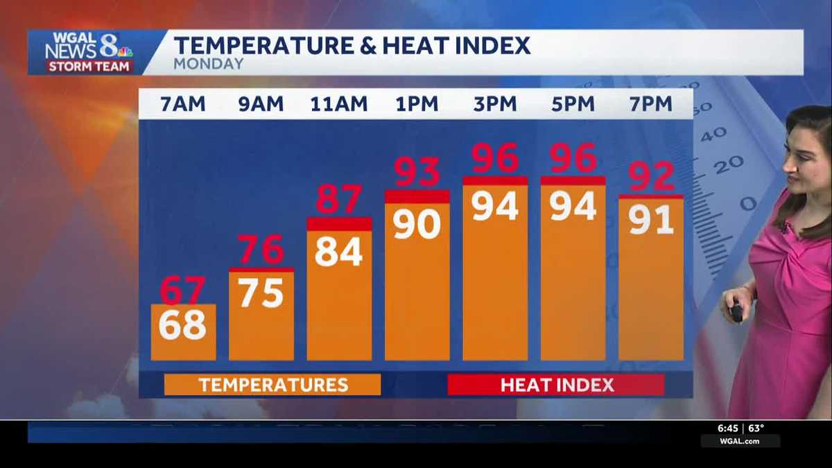
ALL DAY FORECAST WITH THE WGAL NEWS EIGHT STORM TEAM. GOOD MORNING. IT IS 645 IMPACTS FOR HEAT TODAY AND TOMORROW. WE ARE GOING TO SIZZLE HERE WITH HIGH TEMPERATURES WELL INTO THE 90S CHALLENGING RECORD HIGHS. SO HERE’S THE TEMPERATURE TODAY. IN THE ORANGE BOXES WE GET 94 WHICH IS THE RECORD. AND THEN THE HEAT INDEX ON TOP OF IT THERE IN THE RED IT’S GOING TO FEEL LIKE 96 DEGREES WHEN YOU FACTOR IN THAT HUMIDITY THIS AFTERNOON. IN ADDITION, WE HAVE A FEW THUNDERSTORMS POSSIBLE TOWARD EVENING, I’D SAY ISOLATED AT BEST. IF YOU DO SEE A THUNDERSTORM, THERE’S A CHANCE THAT IT COULD PRODUCE ISOLATED DAMAGING WIND GUSTS AND BRIEF HEAVY RAIN. THE HIGHEST CHANCE I’D FAVOR WEST OF THE RIVER AROUND DINNERTIME UNTIL ABOUT SUNSET. SO YOU CAN SEE THAT HERE ON THE PREDICTOR. NOT MUCH HAPPENING ALL DAY BESIDES THAT SWELTERING HEAT AND HIGH HUMIDITY. BUT HERE’S THOSE ISOLATED THUNDERSTORMS STARTING AT 5 P.M. BY 7:00, THEY ARE WEST OF THE RIVER, AND THEN THEY FIZZLE OUT AFTER THE SUN GOES DOWN EAST OF THE SUSQUEHANNA RIVER. NEWS EIGHT STORM TEAM FORECAST TODAY. THE BIG STORY. IT’S THE HEAT. SO WE’RE GOING WITH HOT AND HUMID CONDITIONS FOR THIS TIME OF THE YEAR. WITH THAT TEMPERATURE UP NEAR 94 DEGREES THIS EVENING. STRAY THUNDERSTORMS STILL WARM AND STICKY, ESPECIALLY AT 8:00, WILL BE WELL INTO THE UPPER 80S. TONIGHT WE DROP DOWN TO ABOUT 68 DEGREES, MOSTLY CLEAR, WARM AND HUMID. THERE COULD BE A TOUCH OF PATCHY FOG. AND TOMORROW WE DO IT AGAIN. SAME EXACT FORECAST. WE GET THE SIZZLING SUNSHINE NEAR RECORD HEAT. THE RECORD STANDS AT 95 AND A STRAY SHOWER OR THUNDERSTORM TOWARD EVENING. HERE’S YOUR CURRENTS AT 64 DEGREES IN HARRISBURG, 59. YORK 60 IN LANCASTER. AND BOY, THIS IS THE COOLEST TIME OF THE DAY. SO IF YOU WANT TO GET OUT FOR A WALK OR RUN WATER THE GARDEN, NOW IS THE TIME TO DO IT. IT’S GOING TO FEEL HUMID THIS AFTERNOON, ESPECIALLY FOR MAY. WE HAVE DEW POINTS IN THE LOW TO MID 60S. SAME DEAL FOR TOMORROW, BUT ON WEDNESDAY A COLD FRONT COMES THROUGH AND THAT REALLY CHANGES THE GAME. AT THE END OF THE WEEK IT WILL FEEL MUCH MORE COMFORTABLE BY THURSDAY FRIDAY INTO THE HOLIDAY WEEKEND. BUT IT’S ALSO GOING TO BE CONSIDERABLY COOLER. WEATHER HEALTH UPDATE TREE POLLEN LEVELS ARE HIGH TODAY. OUR AIR QUALITY IS MODERATE FOR OZONE AND PARTICULATES. LOOK AT THE UV INDEX. IT’S A HIGH ONE WITH A BURN TIME OF JUST 20 MINUTES. YOU CAN THANK HIGH PRESSURE FOR ALL THIS HEAT AND HUMIDITY. IT’S SITTING RIGHT OFFSHORE NOW, CRANKING UP THOSE STRONG SOUTHERLY WINDS. SO BOTH TODAY AND TOMORROW, THE PEAK OF THE HEAT THIS WEEK IN OUR TEN DAY FORECAST, THERE’S THE BIG BLUE H STAYING RIGHT TO OUR SOUTH, GIVING US THAT SOUTHERLY WIND AND THE ISOLATED CHANCE OF A SHOWER OR THUNDERSTORM TOWARD EVENING FOR TOMORROW. SAME FORECAST REPEATS. SUN IN THE MORNING. A FEW SHOWERS BUBBLE UP IN THE AFTERNOON AND THEN THINGS QUIET DOWN LATE IN THE EVENING. HERE WE GO INTO WEDNESDAY WITH A COLD FRONT COMING IN WEDNESDAY MORNING WE GET SUNSHINE WEDNESDAY AFTERNOON. CLOUDS INCREASE AND THEN WE GET SOME OF THOSE SCATTERED SHOWERS AND THUNDERSTORMS WEDNESDAY AFTERNOON. WEDNESDAY EVENING, ISOLATED STORMS MAY PRODUCE HEAVY RAIN AND DAMAGING WIND GUSTS ON WEDNESDAY. SO ALL OF THOSE DAYS ARE IMPACT DAYS FOR THE HEAT AND THE STORM CHANCE AFTER THAT. THURSDAY’S HIGH IS 68. FRIDAY WE’RE AT 64. SATURDAY HOLDS THE BEST CHANCE FOR RAIN OVER THE HOLIDAY WEEKEND. THEN WE’LL JUST SEE SOME INTERMITTENT SHOWERS ON SUNDAY, MEMORIAL DAY AND TUESDAY. SO IT CERTAINLY WON’T BE RAINING ALL THE TIME. TEMPERATURES EVENTUALLY GET BACK UP TO 72 ON MEMORIAL DAY, AND TH
Sizzling hot highs will challenge records today and tomorrow in south-central Pennsylvania
Highs will reach the mid-90s, and humidity will be higher than average over the next 2 days

Updated: 9:27 AM EDT May 18, 2026
IMPACT FOR HEAT:Mostly sunny skies are in store this afternoon, and it will warm quickly! Expect temperatures in the 90s by 1 p.m., and highs will reach 94 degrees, which is the record, set in 1962. Winds will be light, and dew points will hover in the low-to-mid 60s, making it feel humid for this time of the year. An isolated evening thunderstorm is possible, mainly west of the Susquehanna River. Isolated damaging wind gusts are the main threat, along with brief, heavy rain. Storms will fizzle after dark.Tonight, lows will fall to the upper 60s under mostly clear skies. Patchy fog is possible and it will feel muggy. Tonight’s record warm low is 67, and we’re forecasting 68 degrees. Get ready to sizzle again Tuesday! Highs will reach 95 degrees, which is the record, set in 1962. It will feel humid, and isolated thunderstorms are possible by evening. HIGHEST CHANCE OF STORMS WEDNESDAY:Ahead of a cold front, highs will reach the upper 80s Wednesday. Look for morning sun, then increasing clouds and scattered thunderstorms in the afternoon and evening. Isolated storms could produce damaging wind gusts.TEMPERATURE RELIEF:By Thursday, highs will fall to the upper 60s. Isolated showers may linger along the PA/MD state line. A few showers are possible Friday, with highs in the low 60s, then Saturday holds the best chance of rain over the holiday weekend. Saturday’s highs will reach 62 degrees.UNSETTLED PATTERN:Scattered showers are in store Sunday, Memorial Day and Tuesday, but I don’t see any washouts. Highs will climb from the mid-60s Sunday to the low 70s Monday, then mid-70s Tuesday. By Wednesday, highs will rebound to 80 degrees.
IMPACT FOR HEAT:
Mostly sunny skies are in store this afternoon, and it will warm quickly! Expect temperatures in the 90s by 1 p.m., and highs will reach 94 degrees, which is the record, set in 1962. Winds will be light, and dew points will hover in the low-to-mid 60s, making it feel humid for this time of the year.
An isolated evening thunderstorm is possible, mainly west of the Susquehanna River. Isolated damaging wind gusts are the main threat, along with brief, heavy rain. Storms will fizzle after dark.
Tonight, lows will fall to the upper 60s under mostly clear skies. Patchy fog is possible and it will feel muggy. Tonight’s record warm low is 67, and we’re forecasting 68 degrees.
Get ready to sizzle again Tuesday! Highs will reach 95 degrees, which is the record, set in 1962. It will feel humid, and isolated thunderstorms are possible by evening.
HIGHEST CHANCE OF STORMS WEDNESDAY:
Ahead of a cold front, highs will reach the upper 80s Wednesday. Look for morning sun, then increasing clouds and scattered thunderstorms in the afternoon and evening. Isolated storms could produce damaging wind gusts.
TEMPERATURE RELIEF:
By Thursday, highs will fall to the upper 60s. Isolated showers may linger along the PA/MD state line.
A few showers are possible Friday, with highs in the low 60s, then Saturday holds the best chance of rain over the holiday weekend. Saturday’s highs will reach 62 degrees.
UNSETTLED PATTERN:
Scattered showers are in store Sunday, Memorial Day and Tuesday, but I don’t see any washouts. Highs will climb from the mid-60s Sunday to the low 70s Monday, then mid-70s Tuesday. By Wednesday, highs will rebound to 80 degrees.