
ALERT – Severe Thunderstorm Watch Issued Across South Central Pennsylvania
Strong & severe thunderstorms are expected across the Susquehanna Valley on Wednesday afternoon. Damaging wind gusts, small hail, and locally heavy rain are the main concerns.
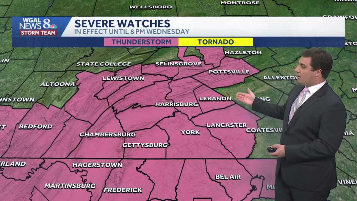
THE FUTURE. NOW, THE WGAL NEWS EIGHT STORM TEAM FORECAST WITH METEOROLOGIST MIKE SUSKO. GOOD AFTERNOON EVERYONE. HERE’S A LOOK AT THE SEVERE THUNDERSTORM WATCH NOW IN EFFECT FOR EVERYONE IN THE SUSQUEHANNA VALLEY UNTIL 8:00 THIS EVENING. SO ALL THE HIGHLIGHTED COUNTIES THERE ARE NOW UNDER THAT SEVERE THUNDERSTORM WATCH. AND WHEN WE’RE LOOKING AT STORM TEAM LIVE RADAR NETWORK, WE DO HAVE SOME THUNDERSTORMS THERE JUST SOUTH OF BEDFORD, BEDFORD, HEADING TOWARDS FRANKLIN COUNTY. SO FRANKLIN COUNTY, PROBABLY WITHIN THE NEXT HOUR, HOUR AND A HALF, YOU’RE GOING TO START SEEING THOSE THUNDERSTORMS ACROSS THE AREA. THE GOOD NEWS IS NONE OF THEM ARE SEVERE AT THE MOMENT, BUT THEY ARE LOOKING LIKE THEY’RE INTENSIFYING AS WE ARE LOOPING THE RADAR HERE. SO THEY ARE STARTING TO TAP INTO MORE ENERGY, MORE AVAILABLE INGREDIENTS. AND THAT’S GOING TO INTENSIFY THEM AS WE GO THROUGHOUT THE AFTERNOON AND EVENING, JUST AS THEY MOVE INTO THE SUSQUEHANNA VALLEY, WHICH IS WHY WE HAVE THAT WATCH. SO HERE’S A LOOK AT THE FORECAST GOING FOR AN ALERT DAY NOW THROUGH ABOUT 8:00 THE MATCH, THE SEVERE THUNDERSTORM WATCH THERE. SO THAT WILL BE THE TIME WHEN WE START TO SEE THINGS WIND DOWN IS AFTER 8 P.M. AND WE WILL KEEP AGAIN, KEEP AN EYE OUT FOR THE DAMAGING WIND THREAT, ESPECIALLY ACROSS OUR AREA. THAT’S THE HIGHEST CONCERN AS WE GO INTO THE AFTERNOON. SMALL HAIL IS ALSO POSSIBLE AS WELL. FLASH FLOODING IS NOT COMPLETELY ZERO, BUT IT IS A VERY LOW THREAT AND THERE IS NO TORNADO THREAT WITH THIS SYSTEM AS IT MOVES ON IN. TONIGHT, CLOUDY SKIES. ONCE THE STORMS COME TO AN END. LIGHT RAIN, THOUGH, DEVELOPS AS WE HEAD INTO TOMORROW. IT WON’T BE AS MUGGY TONIGHT AS TEMPERATURES DROP BACK TO THE MID TO UPPER 50S, SO WE’LL ACTUALLY BE A LITTLE BIT BETTER OVERNIGHT CONDITION WISE. AND WHEN YOU FACTOR THE TEMPERATURES FOR TOMORROW. NOW TOMORROW ONLY GETTING UP TO AROUND 62 DEGREES. SO WE GO FROM THE 80S AND UPPER 80S TODAY TO THE LOW 60S TOMORROW. IT WILL BE A RAINY DAY TOMORROW AS WELL WITH ALSO THOSE SHOWERS TAPERING IN THE AFTERNOON. SO LET’S TIME THIS OUT FOR YOU THE NEXT FEW HOURS. WE’LL START TO SEE THOSE SHOWERS AND THUNDERSTORMS DEVELOP. NOTICE THE REDS AND EVEN THE REDS THERE INDICATING DOWNPOURS. MAYBE THE RADAR MODEL TRYING TO INDICATE SOME LITTLE BIT OF SMALL HAIL POPS, POSSIBLY AS THESE STORMS MOVE ON THROUGH. BUT AGAIN, 4 OR 5, 6:00 THIS EVENING, THAT’S WHEN WE’RE GOING TO SEE THOSE SHOWERS AND THUNDERSTORMS REALLY MOVE THROUGH OUR AREA. ONCE THE SUN GOES DOWN, WE START TO LOSE THE INGREDIENTS AND WE LOSE THE SEVERE WEATHER PIECE OF THIS. BUT WE DO NOT LOSE THE RAIN ENTIRELY BECAUSE ONCE WE GO INTO TOMORROW, IT’S NOT SEVERE WEATHER, BUT WE DO HAVE RAIN PRETTY MUCH MOST OF THE DAY. THERE WILL BE SOME BREAKS HERE AND THERE. I THINK YOUR BEST SHOT EARLY MORNING IS TO GET OUT, AVOID THE RAIN, BUT ESPECIALLY SOUTH OF THE TURNPIKE. BUT YOU CAN SEE WE DO HAVE THAT RAIN TOMORROW AFTERNOON AS WELL. AND THEN FROM NORTHWEST TO SOUTHEAST, THAT RAIN WILL COME TO AN END BY SUNSET TOMORROW FOR MOST, IF NOT EVERYBODY, AS WE HEAD INTO FRIDAY FRIDAY, HIGH PRESSURE IS GOING TO TRY TO REGAIN CONTROL OVER THE GREAT LAKES, AND THAT WILL SHOVE THE RAIN TO THE SOUTH. SO WE STAY DRY FOR MOST OF THE DAY. ON FRIDAY. STILL CLOUDY, STILL COOL, BUT IT WILL KEEP THAT RAIN MAINLY TO THE SOUTH HERE UNTIL WE GET INTO FRIDAY NIGHT AND SATURDAY. THAT WILL BE THE NEXT CHANCE FOR RAIN, BUT BETWEEN NOW AND FRIDAY EVENING YOU CAN EXPECT IN SOME CASES PICKING UP OVER AN INCH OF RAIN. IT WILL BE VERY LOCATION DEPENDENT. YOU CAN SEE A WIDE SPREAD HERE ACROSS THE AREA THAT’S EXPECTED WITH SCATTERED THUNDERSTORMS. SOME OF THEM PRODUCE HEAVY RAIN, OTHERS REALLY DON’T. SO IT REALLY JUST DEPENDS ON YOUR LOCATION. AND THEN ONCE WE GET INTO THE WEEKEND, I KNOW A LOT OF YOU HAVE BEEN WONDERING ABOUT MEMORIAL DAY WEEKEND. UNFORTUNATELY, NOT GOING TO BE THE BEST, ESPECIALLY SATURDAY. IT’S RAINY AND COOL FOR MOST OF THE DAY. HIGH OF ONLY 56. THE RECORD COLD HIGH IS 54, JUST TO PUT IT IN PERSPECTIVE. SO IT’S GOING TO BE A COLD START TO THE WEEKEND FOR THIS TIME OF YEAR. WE DO MODERATE THOUGH, BACK TO 70 DEGREES BY MEMORIAL DAY ITSELF. BUT IF YOU’RE WONDERING WHEN WOULD I BE ABLE TO GET OUT AND AVOID THE RAIN AND MAYBE EVEN HAVE SOME SUNSHINE OVER THE WEEK, THE LONG WEEKEND LOOKS LIKE MONDAY IS GOING TO BE YOUR BEST BET HERE, BRIAN. AS WE HEA
ALERT – Severe Thunderstorm Watch Issued Across South Central Pennsylvania
Strong & severe thunderstorms are expected across the Susquehanna Valley on Wednesday afternoon. Damaging wind gusts, small hail, and locally heavy rain are the main concerns.

Updated: 1:04 PM EDT May 20, 2026
Good afternoon,SUN, THEN STORMS TODAY:This afternoon, increasing clouds and highs in the mid-80s precede scattered showers and thunder, which may develop into this evening. A severe thunderstorm watch has been issued for much of south-central Pennsylvania, with conditions expected to last until 8 PM. Affected areas could expect damaging wind gusts and small hail. Heavy rain is also possible, along with frequent lightning. Tonight, the cold front will linger across Delmarva, and low pressure will develop along the front, leading to a period of light rain. It won’t be as muggy, and temperatures will be cooler, in the mid-50s.RAINY & COOLER THURSDAY:Light to moderate rain will continue Thursday morning through early afternoon. Rain will taper from northwest to southeast by late afternoon. Highs will be much cooler, near 62 degrees.DRIER FRIDAY:High pressure will move over the Northeast on Friday, keeping most of the day dry. We may see partial clearing and highs in the 60s. However, low pressure approaching from the southwest will allow rain to return late Friday night into Saturday morning.WET START TO THE HOLIDAY WEEKEND:Saturday holds the best chance of rain over the holiday weekend, and the coolest temperatures, thanks to easterly flow. Saturday’s highs will reach 56 degrees, just shy of the record coolest high for the day. (Record: 54 in 1982.)Scattered showers continue Sunday, but it looks drier by Memorial Day. Highs will hit the low 60s Sunday, then rise to 70 degrees Monday.WARMER NEXT WEEK:A few showers may be around Tuesday and Wednesday, but the trend is toward drier and warmer weather mid-to-late week. Expect highs in the low-to-mid 80s Wednesday through Friday.
Good afternoon,
SUN, THEN STORMS TODAY:
This afternoon, increasing clouds and highs in the mid-80s precede scattered showers and thunder, which may develop into this evening. A severe thunderstorm watch has been issued for much of south-central Pennsylvania, with conditions expected to last until 8 PM. Affected areas could expect damaging wind gusts and small hail. Heavy rain is also possible, along with frequent lightning.
Tonight, the cold front will linger across Delmarva, and low pressure will develop along the front, leading to a period of light rain. It won’t be as muggy, and temperatures will be cooler, in the mid-50s.
RAINY & COOLER THURSDAY:
Light to moderate rain will continue Thursday morning through early afternoon. Rain will taper from northwest to southeast by late afternoon. Highs will be much cooler, near 62 degrees.
DRIER FRIDAY:
High pressure will move over the Northeast on Friday, keeping most of the day dry. We may see partial clearing and highs in the 60s. However, low pressure approaching from the southwest will allow rain to return late Friday night into Saturday morning.
WET START TO THE HOLIDAY WEEKEND:
Saturday holds the best chance of rain over the holiday weekend, and the coolest temperatures, thanks to easterly flow. Saturday’s highs will reach 56 degrees, just shy of the record coolest high for the day. (Record: 54 in 1982.)
Scattered showers continue Sunday, but it looks drier by Memorial Day. Highs will hit the low 60s Sunday, then rise to 70 degrees Monday.
WARMER NEXT WEEK:
A few showers may be around Tuesday and Wednesday, but the trend is toward drier and warmer weather mid-to-late week. Expect highs in the low-to-mid 80s Wednesday through Friday.