
IMPACT – Steady Rain Tonight; Washout & Cool Saturday In South Central Pennsylvania
Saturday will be the coolest and wettest day of the holiday weekend. Sunday features some dry hours for the second half of the day.
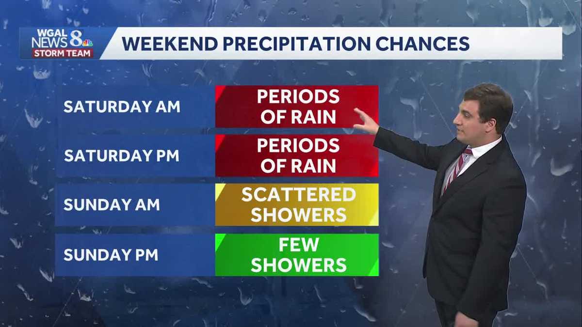
NEXT STEPS FOR THE MONUMENTS WHEN THEY DO ARRIVE IN BALTIMORE. NOW, THE WGAL NEWS EIGHT STORM TEAM FORECAST WITH METEOROLOGIST MIKE SUSKO. AND GOOD EVENING, EVERYONE. UNFORTUNATELY, IT’S GOING TO BE A DISGUSTING NEXT 24 HOURS OR SO, WITH RAIN CONTINUING ACROSS THE AREA, RAIN CHANCES REMAINING HIGH THROUGH THIS EVENING, OVERNIGHT TONIGHT, AND EVEN THROUGHOUT YOUR ENTIRE SATURDAY. SATURDAY IS LOOKING LIKE A WASHOUT HERE. UNFORTUNATELY FOR THE WEEKEND. SO HERE’S A LOOK AT LIVE RADAR NETWORK. WE HAVE THAT RAIN ACROSS THE AREA AT THE MOMENT. SOME LIGHT TO MODERATE RAIN AT TIMES A LITTLE BIT MORE MODERATE RAIN THERE JUST BETWEEN HARRISBURG AND YORK THERE. AND ALSO JUST OUTSIDE OF LANCASTER AND WESTERN PARTS OF LANCASTER COUNTY. BUT THIS IS GOING TO CONTINUE AS WE GO THROUGH THE REST OF THE NIGHT AND INTO TOMORROW, AS ALL THAT MOISTURE MAKES ITS WAY TOWARDS THE SUSQUEHANNA VALLEY FROM THE SOUTH AND WEST. NOW, THE GOOD NEWS IS WE DON’T GET THE SEVERE WEATHER PART OF IT, BUT WE JUST GET THE RAIN HERE. UNFORTUNATELY FOR THE HOLIDAY WEEKEND. SO FOR THE REST OF THE EVENING, EXPECT THE RAIN TO CONTINUE. YOU’LL NEED THAT UMBRELLA. YOU’LL NEED THE PONCHO WILL BE SEEING THOSE TEMPERATURES IN THE UPPER 50S AND LOW 60S, DROPPING DOWN TO 50 DEGREES OVERNIGHT TONIGHT FOR THE LOW. WITH THAT WIDESPREAD RAIN CONTINUING, IT’S JUST GOING TO BE A DAMP AND COOL NIGHT TONIGHT WITH THOSE WINDS INCREASING OUT OF THE EAST. AND THEN TOMORROW COULD BE CHALLENGING. A RECORD COLD HIGH. RIGHT NOW IT’S AT 54 DEGREES. SO IF WE STAY AT OR BELOW 54 FROM MIDNIGHT TO MIDNIGHT ON SATURDAY, THEN WE WOULD TIE OR BREAK THAT RECORD FROM 1982. NOT SOMETHING WE DEFINITELY WANT TO BE DOING ON MEMORIAL DAY WEEKEND, BUT NONETHELESS, UNFORTUNATELY, SOMETHING THAT WILL BE AROUND TOMORROW. SO WE HAVE ALL DAY RAIN THAT’S GOING TO LEAD TO A WASHOUT AND LIKELY AFFECT MANY THINGS GOING ACROSS THE SUSQUEHANNA VALLEY TOMORROW. WITH TEMPERATURES REMAINING IN THE LOW 50S ALL DAY. AS WE GO INTO TOMORROW AFTERNOON HERE, TEMPERATURES IN SOME CASES WON’T GET OUT OF THE 40S, AND HIGHER ELEVATIONS. SO IT’S JUST GOING TO BE A PRETTY MISERABLE DAY. UNFORTUNATELY, RAIN TOTALS WILL BE AROUND AN INCH AND A HALF TO 2.5IN. WE WILL HAVE FLOODING. THAT’S THE GOOD NEWS. THE RAIN IS GOING TO COME DOWN SLOW ENOUGH, WHERE THE GROUND WILL BE ABLE TO SOAK IT UP AND WILL NOT LEAD TO ANY FLOODING ISSUES ACROSS OUR AREA, AND IT WILL BE A GOOD HELPING OF RAIN. WE ARE IN A DROUGHT AND THAT SHOULD HELP PUT A NICE DENT IN IT ACROSS PARTS OF THE AREA. YOUR WEEKEND RAIN CHANCES THOUGH SATURDAY. LIKE I SAID, IT’S JUST RAINING MOST OF THE DAY HERE. IF NOT THE ENTIRE DAY. THEN SUNDAY MORNING, SOME SCATTERED SHOWERS THERE IN THE MORNING HOURS, BUT THEN DWINDLING AS WE GO INTO SUNDAY AFTERNOON. SO YOUR SUNDAY AFTERNOON PLANS, DEPENDING ON YOUR LOCATION, MAYBE A. OKAY. WE MAY JUST HAVE A COUPLE SHOWERS AROUND, BUT DEFINITELY A BETTER DAY SUNDAY COMPARED TO SATURDAY HERE. AND THEN WHEN WE GO INTO MONDAY FOR THE FORECAST, A FEW SHOWERS LINGER ON MONDAY AS WELL. TEMPERATURES ON SUNDAY AND MONDAY ARE GOING TO BE WARMING UP TO GO FROM 54 TOMORROW. THE 64 ON SUNDAY. AND THEN WE GET BACK TO THE LOW 70S. BY THE TIME WE GET TO MONDAY ITSELF. SO OUR CONDITIONS KIND OF GRADUALLY IMPROVE AS WE GO THROUGH MEMORIAL DAY WEEKEND HERE. THE REASON FOR THIS IS THE HIGH PRESSURE SYSTEM THAT’S TO OUR NORTH IS EVENTUALLY GOING TO MOVE OFF OUT TO SEA. AND THAT EASTERLY FLOW IS JUST KIND OF LOCKS US IN WITH THE COOL AIR OFF THE ATLANTIC, KEEPS EVERYTHING ON THE COOLER SIDE, KEEPS US WITH THE RAIN AROUND, AND IT’S JUST GOING TO LEAD TO THE RAINY CONDITIONS THAT WE SEE FOR THE NEXT 24 TO 36 HOURS. SO AS WE LOOK AT PREDICTOR, JUST RAIN, RAIN AND MORE RAIN ACROSS THE AREA. BUT THE GOOD NEWS AGAIN, IT’S LIGHT TO MODERATE. SO WE’RE NOT GOING TO BE SEEING THAT ANY FLOODING CONCERNS OR ANYTHING. IT’S JUST UNFORTUNATE TIMING THERE WITH THE WEEKEND AS THIS ROLLS ON THROUGH. WE GOT THAT RAIN THROUGHOUT TOMORROW AFTERNOON TOMORROW EVENING. AND THEN ONCE WE HEAD INTO SUNDAY, ESPECIALLY LATE MORNING OR AFTERNOON, THAT’S WHEN THINGS BEGIN TO WIND DOWN WITH THE RAIN. BUT LIKE I SAID, COULD PICK UP AN INCH AND A HALF TO 2.5IN ACROSS THE SUSQUEHANNA VALLEY. SO WE’LL PUT A NICE DENT IN THOSE DROUGHT CONDITIONS THAT WE’VE BEEN SEEING, ESPECIALLY SOUTH OF THE TURNPIKE. YOUR TEN DAY FORECAST ALSO SHOWING IMPROVEMENT BEYOND THIS MEMORIAL DAY WEEKEND. WE’LL GET BACK TO 78 BY TUESDAY, AND RAIN CHANCES WILL DWINDLE AS WE HEAD INTO NEXT WEEK. WITH DRY WEATHER FROM THURSDAY
IMPACT – Steady Rain Tonight; Washout & Cool Saturday In South Central Pennsylvania
Saturday will be the coolest and wettest day of the holiday weekend. Sunday features some dry hours for the second half of the day.

Updated: 7:39 PM EDT May 22, 2026
Good evening,Steady rain has developed over the Valley this evening. Expect a light northeasterly breeze and cool highs around 62. Today’s average high is 75.Tonight, rain will become widespread and could be moderate to briefly heavy at times. Lows will fall to 50 degrees.Saturday holds the best chance of steady, light to moderate rain over the holiday weekend. It will also feature the coolest temperatures, thanks to the easterly flow. Look for highs near 54 degrees, which is the coldest high for the day, set in 1982. You’ll also notice a 10-15 mph breeze. There will be breaks in the rain by evening, but we’re not done with the rain just yet. Rain totals from today through Saturday will range between 1.50″ to 2.50″.Sunday will feature early morning rain tapering to showers, then drier weather is expected by afternoon. Mainly cloudy skies will lead to cool highs in the low 60s.Memorial Day will be the warmest and driest day of the holiday weekend, with highs near 70 and a few showers possible.Isolated showers may be around Tuesday and Wednesday, but the trend is toward drier and warmer weather mid-week. Expect highs in the low 80s Wednesday and Thursday, then mild and comfortable highs in the mid-70s Friday through Sunday.Have a great night!
Good evening,
Steady rain has developed over the Valley this evening. Expect a light northeasterly breeze and cool highs around 62. Today’s average high is 75.
Tonight, rain will become widespread and could be moderate to briefly heavy at times. Lows will fall to 50 degrees.
Saturday holds the best chance of steady, light to moderate rain over the holiday weekend. It will also feature the coolest temperatures, thanks to the easterly flow. Look for highs near 54 degrees, which is the coldest high for the day, set in 1982. You’ll also notice a 10-15 mph breeze. There will be breaks in the rain by evening, but we’re not done with the rain just yet. Rain totals from today through Saturday will range between 1.50″ to 2.50″.
Sunday will feature early morning rain tapering to showers, then drier weather is expected by afternoon. Mainly cloudy skies will lead to cool highs in the low 60s.
Memorial Day will be the warmest and driest day of the holiday weekend, with highs near 70 and a few showers possible.
Isolated showers may be around Tuesday and Wednesday, but the trend is toward drier and warmer weather mid-week. Expect highs in the low 80s Wednesday and Thursday, then mild and comfortable highs in the mid-70s Friday through Sunday.
Have a great night!