
Comfortable Tuesday; Warming Temperatures Late Week In South Central Pennsylvania
Highs on Tuesday reach the mid & upper 70s, with 80s returning Wednesday.
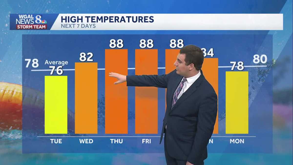
YOU’LL BE MEETING A LOT OF PEOPLE AND SEE WHERE YOUR DONATIONS GO. WEATHER LOOKING GREAT TOO FOR THIS. LOVE THIS WEATHER. THIS IS BEAUTIFUL, MIKE. YES, IT’S GOING TO BE BEAUTIFUL FOR THE ENTIRE WEEK HERE. AND TEMPERATURES WILL START TO WARM UP AS WE HEAD TOWARDS THURSDAY. THAT’S WHEN WE GET BACK INTO THE UPPER 80S, AND WE COULD EVEN TOUCH 90 DEGREES IN SOME CASES HERE. AS WE HEAD TOWARDS THE LATER PART OF THE WEEK. AND IF YOU’RE WONDERING ABOUT RAIN CHANCES, IT’S NOT UNTIL THE END OF THE WEEKEND. SUNDAY AND MONDAY WILL BE OUR NEXT CHANCE FOR ANY RAIN HERE IN THE SUSQUEHANNA VALLEY. SO IF YOU HAVE PLANS THIS WEEK, THE REST OF THIS WEEK AND THEY’RE OUTSIDE, YOU DON’T HAVE TO WORRY ABOUT THE RAIN AT ALL, INCLUDING HERE IN HARRISBURG. WE GOT A MIX OF SUN AND CLOUDS OUT THERE AND JUST A GORGEOUS EVENING HERE ACROSS THE SUSQUEHANNA VALLEY, 76 DEGREES. THE CURRENT TEMPERATURE IN HARRISBURG. AND WHEN YOU LOOK AT THE HUMIDITY FORECAST, WE STAY IN THE COMFORTABLE ZONE TOMORROW, WEDNESDAY AND THURSDAY. SO FOR THE NEXT COUPLE OF DAYS, IT’S GOING TO BE LIKE THIS. IT STARTS TO GET A LITTLE MORE HUMID AS WE HEAD INTO FRIDAY, BUT IT’S NOT TOO BAD. STORM TEAM LIVE RADAR NETWORK. IT IS QUIET ACROSS THE SUSQUEHANNA VALLEY. THERE’S A FEW SHOWERS THERE DOWN NEAR WEST VIRGINIA AND VIRGINIA, BUT THEY’RE GOING TO STAY TO THE SOUTH AND WEST FOR YOUR EVENING. 70 DEGREES THIS EVENING, BECOMING 52 OVERNIGHT TONIGHT WITH A PARTLY CLOUDY SKY. A STRAY SHOWER IS POSSIBLE AS SOME UPPER LEVEL ENERGY MOVES OVERHEAD. THAT WILL ALSO BE THE CASE TOMORROW AFTERNOON, BUT IT’S GOING TO BE MORE THE EXCEPTION THAN THE RULE, WITH A HIGH AROUND 76 DEGREES. ALSO, IN A COUPLE HOURS, RIGHT AFTER SUNSET, GO OUTSIDE, LOOK TO NORTHWEST. YOU MAY SEE MERCURY, VENUS AND JUPITER HERE ON THE HORIZON OR JUST ABOVE THE HORIZON LATER ON TONIGHT. AND WHEN WE LOOK AT VIEWING CONDITIONS SHOULD BE PRETTY GOOD. WE’LL HAVE A COUPLE CLOUDS OFF TO THE WEST HERE, BUT SHOULD BE THIN ENOUGH WHERE YOU CAN SEE SOME OF THE PLANETS THERE. HIGH PRESSURE IS BACK IN CONTROL FOR YOUR TUESDAY AGAIN. SPOTTY SHOWER IN THE AFTERNOON. NOT OUT OF THE QUESTION, BUT IT’S VERY HIT OR MISS AS WE GO INTO WEDNESDAY. HIGH PRESSURE IS STILL IN CONTROL FOR THE SUSQUEHANNA VALLEY. THAT BRINGS IN EVEN NICER CONDITIONS. WINDS ARE A LITTLE BIT OUT OF THE SOUTH. THAT’S WHY YOU START TO SEE THOSE TEMPERATURES GO UP AS WE HEAD INTO YOUR WEDNESDAY, 82 DEGREES ON WEDNESDAY, THEN HITTING THE UPPER 80S BY THE TIME WE GET TO THURSDAY, FRIDAY AND SATURDAY, ABOUT TEN DEGREES ABOVE AVERAGE FOR THIS TIME OF YEAR. YOUR TEN DAY FORECAST SHOWING ONCE AGAIN THE REST OF THIS WEEK IS WARM, IT’S GOING TO BE A PLEASANT WEEKEND OR WEEK AHEAD BEFORE IT STARTS TO FEEL MORE HUMID BY SATURDAY A
Comfortable Tuesday; Warming Temperatures Late Week In South Central Pennsylvania
Highs on Tuesday reach the mid & upper 70s, with 80s returning Wednesday.

Updated: 11:30 PM EDT Jun 1, 2026
Good evening, Tonight, lows will fall to near 52° under partly cloudy skies. A spotty shower may drift through the area, but most of the region remains dry.It’s a similar day tomorrow with sun to start, more clouds in the afternoon, and a stray shower. Highs will be comfortable, in the mid-70s, and low humidity.As high pressure sits just to our west, temperatures will climb to the low 80s Wednesday, but humidity will stay at comfortable levels.By Thursday and Friday, highs will warm up and reach the upper 80s, and some spots could touch 90°, especially in our typical warm spots! While it is still rather comfortable Thursday, you’ll notice the stickiness on Friday as the humidity starts to increase.You’ll notice higher humidity on Saturday. Highs will stay in the upper 80s, then fall to the mid-80s Sunday, as a chance of thunderstorms returns in the forecast.As a cold front passes on Monday, expect a chance of thunderstorms and cooler highs in the upper 70s. Unsettled weather continues Tuesday and Wednesday, with isolated chances for rain. Highs will rebound to the low 80s.Have a great night!
Good evening,
Tonight, lows will fall to near 52° under partly cloudy skies. A spotty shower may drift through the area, but most of the region remains dry.
It’s a similar day tomorrow with sun to start, more clouds in the afternoon, and a stray shower. Highs will be comfortable, in the mid-70s, and low humidity.
As high pressure sits just to our west, temperatures will climb to the low 80s Wednesday, but humidity will stay at comfortable levels.
By Thursday and Friday, highs will warm up and reach the upper 80s, and some spots could touch 90°, especially in our typical warm spots! While it is still rather comfortable Thursday, you’ll notice the stickiness on Friday as the humidity starts to increase.
You’ll notice higher humidity on Saturday. Highs will stay in the upper 80s, then fall to the mid-80s Sunday, as a chance of thunderstorms returns in the forecast.
As a cold front passes on Monday, expect a chance of thunderstorms and cooler highs in the upper 70s. Unsettled weather continues Tuesday and Wednesday, with isolated chances for rain. Highs will rebound to the low 80s.
Have a great night!