
Scattered rain, thunderstorms return to Western Pennsylvania for a busy Saturday weekend
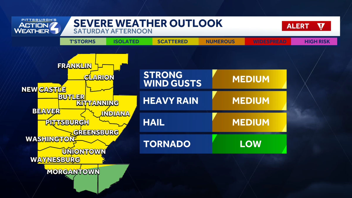
THAT’S A TEN MINUTE RIDE AT TURNPIKE TO VETERANS BRIDGE THIS MORNING, ASHLEY AND ALL IS CALM AND QUIET AS YOU HEAD OUT THE DOOR THIS MORNING AND THROUGH THE DAY CHANGES, THOUGH FOR A SEVERE WEATHER ALERT DAY ON SATURDAY. HERE’S THE TIMING OF IT. SATURDAY MORNING WE’LL HAVE SOME PASSING SHOWERS, POTENTIALLY NON-SEVERE STORM POPPING. IT’S ALL EYES ON THE AFTERNOON AND EVENING AS THAT FRONT MOVES THROUGH. WE COULD HAVE SOME STRONG TO SEVERE THUNDERSTORMS. A STRAY SHOWER EARLY SUNDAY BEFORE YOU WAKE UP. REALLY THE WORST OF IT WILL BE ON SATURDAY. DAMAGING WIND GUSTS, HEAVY RAIN AND HAIL WILL BE OUR BIGGEST THREAT WITH THESE STORMS. TORNADO THREAT IS LOW BUT CAN’T BE RULED OUT. AND PRETTY MUCH THE STORM PREDICTION CENTER HAS PUT OUR ENTIRE VIEWING AREA UNDER A LEVEL TWO OUT OF FIVE. WITH THE SEVERITY OF SOME OF THOSE STORMS DEVELOPING. LET’S TIME IT OUT HERE ON OUR FUTURE CAST AS WE PROGRESS INTO SATURDAY MORNING AS EARLY AS 5:06 A.M., START TO SEE SOME OF THOSE POP UP SHOWERS. THAT’S GOING TO LINGER UNTIL ABOUT 11:00 NOW, AROUND LUNCHTIME, EARLY AFTERNOON, BEFORE THAT FRONT GETS INTO OUR AREA, WE’RE GOING TO SEE THESE CLOUDS BREAK UP A LITTLE BIT. THAT’S NOT A GOOD THING. WE’LL HAVE SUNSHINE, IT WILL FEEL NICE. BUT THE THING IS THAT ADDS TO THE INSTABILITY. JUST ADDING FUEL TO THE FIRE, BASICALLY. SO AS THAT FRONT APPROACHES, WE HAVE THE HIGHER HEAT IN THE MID 80S, THE HUMIDITY WILL BE UP. AND THAT SUNSHINE IS JUST GOING TO ADD TO IT. THAT’S WHEN SOME OF THOSE STORMS COULD TURN SEVERE. I DO THINK THE RANGE WILL BE ABOUT BETWEEN 3 AND 5:00 WITH THE ONSET OF IT. AND THAT’S GOING TO START JUST NORTH OF THE CITY AS IT PUSHES THROUGH, THESE STORMS COULD START TO GO ROGUE AND BREAK UP AND KIND OF SEPARATE HERE. AND THAT’S WHAT IT LOOKS LIKE COULD HAPPEN AS WE GET AROUND 7:00 8:00. CLARION ARMSTRONG EVEN INDIANA COULD SEE SOME OF THOSE STRONGER STORMS ALSO INTO WASHINGTON AND GREENE. THIS DOESN’T MEAN THIS IS GOING TO HOLD, BUT THIS IS KIND OF WHAT IT’S LOOKING LIKE FOR US NOW. ALLEGHENY COUNTY, EVEN PORTIONS OF BEAVER AND BUTLER LAWRENCE LOOK TO BE RELATIVELY QUIET. AND THEN THAT WILL CONTINUE TO PUSH SOUTHWARD BY 9:00. STILL, SOME POCKETS OF HEAVY RAIN INTO FAYETTE AND GREENE THAT EXITS THINGS QUIET DOWN. EARLY MORNING SHOWER AROUND MIDNIGHT. OTHERWISE SOME AREAS OF PATCHY FOG TO KICK OFF YOUR SUNDAY. THERE IS A MARGINAL RISK TOMORROW FOR EXCESSIVE RAINFALL, SO THE POTENTIAL FOR SOME MINOR FLOODING. KEEP IN MIND THE GROUND IS REALLY HARD AND IT COULD JUST KIND OF ROLL OFF AND CAUSE SOME MINOR FLOODING IS REALLY HAVEN’T HAD ANY RAIN THE PAST WEEK AS THIS STORM MOVES THROUGH. HERE’S SOME PROJECTED NUMBERS. COULD SEE ABOUT A HALF AN INCH TO THREE QUARTERS OF AN INCH, ESPECIALLY SOME OF THOSE HARD HIT AREAS, POTENTIALLY ARMSTRONG, INDIANA, EVEN INTO FAYETTE, WASHINGTON AND GREENE COUNTY. AS WE HEAD INTO OUR SATURDAY. SO SOMETHING WE’LL BE WATCHING VERY CLOSELY AS WE HAVE UPGRADED IT TO A SEVERE WEATHER ALERT DAY WITH THOSE STRONG TO SEVERE THUNDERSTORMS COMING IN FOR THE AFTERNOON. EVENING CALMS DOWN ON SUNDAY, AND THAT ISOLATED SHOWER EARLY. LOOK AT THOSE TEMPERATURES STAYING SUMMER-LIKE EVEN THROUGH THE WEEKEND AND INTO NEXT WEEK. IT’S BEAUTIFUL OUT AS YOU GET READY TO STEP OUT THE DOOR. IF YOU HAVE SOME GRADUATION PARTIES GOING ON LATER TODAY, OUR KIDS ARE GRADUATING. CONGRATULATIONS. IT’S GOING TO BE VERY NICE TO CELEBRATE 59 DEGREES RIGHT NOW IN PITTSBURGH, 54 AS YOU WAKE UP IN GREENSBURG, WASHINGTON, AT 5353 IN NEW CASTLE, CLARION 55 WILL JUMP IN THE MID TO UPPER 80S TODAY, YOU NOTICE A BIT MORE CLOUD COVER MIXING IN, ESPECIALLY THROUGH THE AFTERNOON, AND THAT HUMIDITY STARTING TO TICK UP JUST A LITTLE BIT. IT WILL BE VERY MUGGY AGAIN AS WE HEAD INTO THE WEEKEND. HUMIDITY SHOULD STICK AROUND A LITTLE BIT FOR NEXT WEEK. SO WILL THAT WARM AIR. WE’RE TALKING ALMOST NEAR 90 ON
Scattered rain, thunderstorms return to Western Pennsylvania for a busy Saturday weekend

Updated: 7:18 AM EDT Jun 5, 2026
A sunny stretch ends Saturday, when storms are expected to move through the Pittsburgh area during a busy weekend of festivals, concerts and graduations.Expect scattered showers and thunderstorms for the second half of Saturday.Alert Day SaturdayIt is likely to be a busy weekend around western Pennsylvania with the Three Rivers Arts Festival, the Morgan Wallen concerts, Pittsburgh Pride events, along with graduations and parties.Saturday will feature the chance for some scattered showers in the morning before the main action arrives after 2 p.m. Scattered storms to a line of storms are expected to develop along the I-80 corridor, moving south through the day. This line of storms should be in Pittsburgh between 5 p.m. and 8 p.m. Strong winds, large hail, lightning and heavy rain are all possible. A tornado cannot be ruled out. For the threat of stronger storms in the afternoon and evening, Saturday is an Alert Day.Rain showers look to now taper off very early Sunday morning. Outside of an isolated shower, Sunday will be dry and humid.Warm all weekHigh pressure starts to nose back into the area on Monday. Temperatures will remain in the mid to upper 80s throughout much of next week. There will be a chance for rain showers on Wednesday and Thursday.FRIDAY: Partly cloudy and feeling like summer. High: 88°, low: 68°.SATURDAY: Alert Day: Rain showers and thunderstorms, primarily during the afternoon and evening. High: 86°, low: 66°.SUNDAY: Partly cloudy with an isolated shower possible. High: 84°, low: 62°.
A sunny stretch ends Saturday, when storms are expected to move through the Pittsburgh area during a busy weekend of festivals, concerts and graduations.
Expect scattered showers and thunderstorms for the second half of Saturday.
Alert Day Saturday
It is likely to be a busy weekend around western Pennsylvania with the Three Rivers Arts Festival, the Morgan Wallen concerts, Pittsburgh Pride events, along with graduations and parties.
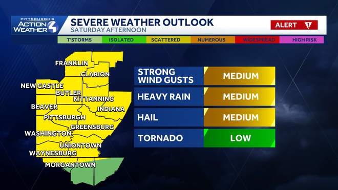
Saturday will feature the chance for some scattered showers in the morning before the main action arrives after 2 p.m.
Scattered storms to a line of storms are expected to develop along the I-80 corridor, moving south through the day.
This line of storms should be in Pittsburgh between 5 p.m. and 8 p.m. Strong winds, large hail, lightning and heavy rain are all possible. A tornado cannot be ruled out. For the threat of stronger storms in the afternoon and evening, Saturday is an Alert Day.
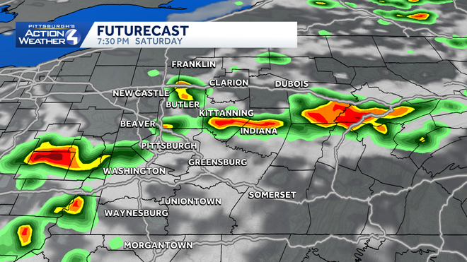
Rain showers look to now taper off very early Sunday morning. Outside of an isolated shower, Sunday will be dry and humid.
Warm all week
High pressure starts to nose back into the area on Monday. Temperatures will remain in the mid to upper 80s throughout much of next week.
There will be a chance for rain showers on Wednesday and Thursday.
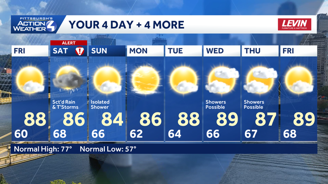
FRIDAY: Partly cloudy and feeling like summer. High: 88°, low: 68°.
SATURDAY: Alert Day: Rain showers and thunderstorms, primarily during the afternoon and evening. High: 86°, low: 66°.
SUNDAY: Partly cloudy with an isolated shower possible. High: 84°, low: 62°.