
IMPACT: Saturday storms could bring damaging winds, hail, lightning to south-central Pennsylvania
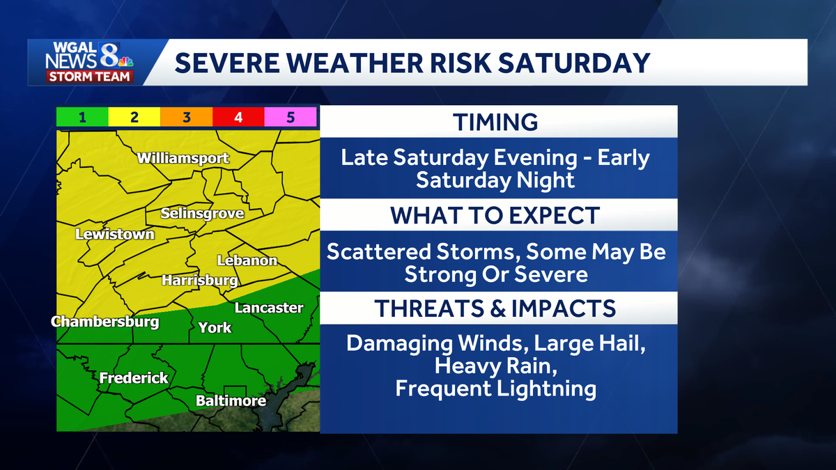
NOW, THE WGAL NEWS EIGHT STORM TEAM FORECAST WITH CHIEF METEOROLOGIST CHRISTINE FERREIRA. GOOD MORNING. IT IS 647. WE HAVE AN UPGRADED CONVECTIVE OUTLOOK FROM THE STORM PREDICTION CENTER THIS MORNING. NOTICE THE YELLOW. THAT IS A SLIGHT RISK NOW FOR AREAS GENERALLY ALONG AND NORTH OF ROUTE 30. SO A LEVEL TWO OUT OF FIVE. FARTHER SOUTH, THE THREAT FOR SEVERE WEATHER DIMINISHES A BIT BECAUSE THE STORMS WILL BE COMING IN AFTER DARK THERE ON SATURDAY SOUTH OF ROUTE 30. SO WHAT ARE THE THREATS WE’RE TALKING ABOUT? I’D SAY DAMAGING WIND GUSTS IS OUR PRIMARY CONCERN, ALONG WITH A CHANCE FOR HAIL THE SIZE OF QUARTERS. SO WE WILL BE WATCHING OUT FOR THOSE TWO THINGS, ALONG WITH FREQUENT LIGHTNING AND SOME BRIEF HEAVY RAIN. LET ME TIME OUT THE STORMS FOR YOU ON SATURDAY. SATURDAY MORNING LOOKING MAINLY DRY. THERE MAY BE A SPOTTY SHOWER AROUND HERE OR THERE IN THE MORNING OR IN THE AFTERNOON, BUT THE CHANCE IS PRETTY SLIM. WE EVEN CLEAR OUT A BIT BY SATURDAY EVENING. AND IF YOU DO HAVE EARLY EVENING PLANS, THEY SHOULD BE A OKAY. IT’S NOT UNTIL LATE EVENING TOWARDS SUNSET WHERE A COLD FRONT STARTS TO APPROACH. LOOK AT THIS. THIS IS 7 P.M. THE STORMS ARE GENERALLY NORTH OF OUR AREA BY ABOUT EIGHT. THEY MOVE INTO THE SUSQUEHANNA VALLEY, AFFECTING HARRISBURG, LEBANON, BACK TOWARD CHAMBERSBURG AND GETTYSBURG. AND THEN BY NINE 10:00, THEY’RE MOVING INTO OUR SOUTHEASTERN COUNTIES. SO NOT A GUARANTEE THAT YOU GET RAIN OUT OF THIS STORM. BUT IF YOU DO, YOU COULD SEE THESE STORMS PACKING QUITE A PUNCH LATE ON SATURDAY. SO OUR NEWS EIGHT STORM TEAM FORECAST TODAY CALLS FOR A MIX OF SUN AND HIGH CLOUDS THIS MORNING. IT’S GOING TO WARM UP FAST. WE’RE TALKING ABOUT 72 AT NINE. 92 FOR THE HIGH. OUR HOTTEST DAY OF THE WEEK. AND IT DOES COME WITH SLIGHTLY HIGHER HUMIDITY. SO IT MIGHT FEEL A BIT STICKY FOR YOU THIS AFTERNOON. THIS EVENING, SUNNY AND WARM. PLEASANT FOR ANY OUTDOOR ACTIVITIES TONIGHT. MILD AND MUGGY. WE CONTINUE TO WARM OVERNIGHT AS WELL WITH LOWS IN THE UPPER 60S TONIGHT. THE IMPACTS ARE LATE IN THE DAY SO THE MORNING. THE AFTERNOON SHOULD BE MAINLY DRY. IT’S NOT UNTIL LATE WHERE WE GET THOSE STRONGER STORMS WITH POTENTIALLY DANGEROUS STORMS IN THE EVENING AND AFTER SUNSET. TEMPERATURES TOMORROW SHOULD GET UP TO 90 AGAIN. RIGHT NOW WE’RE AT 60 IN LEBANON. GOOD MORNING YORK. YOU HAVE 53. 58 LANCASTER, 60 DEGREES IN CHAMBERSBURG. AND OUR DEW POINTS HAVE BEEN SNEAKING UP. IF YOU’VE NOTICED, IF YOU’RE SENSITIVE TO THE HUMIDITY, IT’S STILL NICE AND COMFORTABLE WITH DEW POINTS IN THE 50S OUT THERE, BUT THEY’LL BE BORDERLINE STICKY THIS AFTERNOON. WEATHER AND HEALTH UPDATE. I WANTED TO BRING YOUR ATTENTION TO THE UV INDEX IS HIGH TODAY WITH A BURN TIME OF JUST 20 MINUTES. OUR AIR QUALITY CONTINUES TO BE MODERATE. HIGH PRESSURE HAS BEEN IN THE NAME OF THE GAME THIS WEEK. IT IS CONTINUING TO DOMINATE THE EAST COAST. LOOK AT THAT. HARDLY A CLOUD IN THE SKY. NO STORMS UP AND DOWN THE EAST COAST. CLOSEST STORMS ARE BACK IN THE MIDWEST AND THAT’S WHERE WE GET OUR COLD FRONT FOR LATE SATURDAY. SO HERE’S THE PREDICTOR. YOU KNOW THE BIG BLUE H. IT’S BEEN AROUND ALL WEEK. STILL HERE WITH THE SUNGLASSES ON. LOOKING GOOD TODAY WITH MOSTLY SUNNY SKIES FOR TONIGHT. WE SEE CLEAR CONDITIONS BECOMING PARTLY SUNNY EARLY TOMORROW. AND AGAIN, ASIDE FROM JUST A STRAY SPOTTY SHOWER TOMORROW AFTERNOON, THE THREAT FOR STORMS IS GOING TO BE LATE IN THE DAY, MOST LIKELY AROUND SUNSET OR SHORTLY THEREAFTER. AHEAD OF THAT COLD FRONT COMING IN FRONT PASSES SUNDAY LOOKING GOOD. IT WILL RULE OUT A STRAY SHOWER, BUT SUNDAY IS GOING TO END UP QUITE NICE WITH LOWERING HUMIDITY THROUGHOUT THE DAY. STILL GOING TO BE TOASTY. ON SUNDAY WE GET TO THE UPPER 80S, BUT THEN ONLY 80 ON MONDAY. A LITTLE BIT OF A COOL DOWN, 82 ON TUESDAY. HEAT AND HUMIDITY START TO BUILD WEDNESDAY, WARM AND STICKY IS THE CALL 88. AND THEN TOWARD THE END OF THE WEEK, WE COULD BE FLIRTING WIT
IMPACT: Saturday storms could bring damaging winds, hail, lightning to south-central Pennsylvania

Updated: 7:33 AM EDT Jun 5, 2026
Scattered thunderstorms could bring damaging winds, hail, frequent lightning and brief heavy rain to south-central Pennsylvania late Saturday, making it an Impact Evening. Saturday will be partly sunny, warm and muggy, with highs near 90 before a cold front approaches the region. Storm timingWhile a few showers may develop during the afternoon, the better chance for scattered thunderstorms will come around or after sunset. Forecast models show storms developing during the evening and moving through the Susquehanna Valley into Saturday night. Below: See the forecast predictor for Saturday’s storms. Slight, marginal riskThe Storm Prediction Center has placed areas generally north of Route 30 in a Slight Risk for severe weather, a Level 2 out of 5.Areas south of Route 30 remain in a Marginal Risk, a Level 1 out of 5.Main threatsSome storms could become strong and produce: Damaging wind gustsLarge hailFrequent lightningBrief heavy rainThere is currently no threat of flash flooding or tornadoes. The WGAL News 8 Storm Team will continue to monitor conditions and provide updates as they become available. Did you capture a moment that you would like to share with News 8? Send us your photos or videos at https://www.wgal.com/upload.
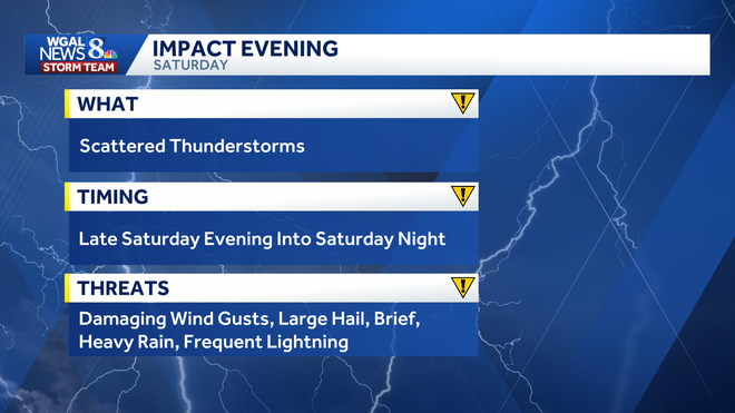
Scattered thunderstorms could bring damaging winds, hail, frequent lightning and brief heavy rain to south-central Pennsylvania late Saturday, making it an Impact Evening.
Saturday will be partly sunny, warm and muggy, with highs near 90 before a cold front approaches the region.
Storm timing
While a few showers may develop during the afternoon, the better chance for scattered thunderstorms will come around or after sunset.
Forecast models show storms developing during the evening and moving through the Susquehanna Valley into Saturday night.
Below: See the forecast predictor for Saturday’s storms.
Slight, marginal risk
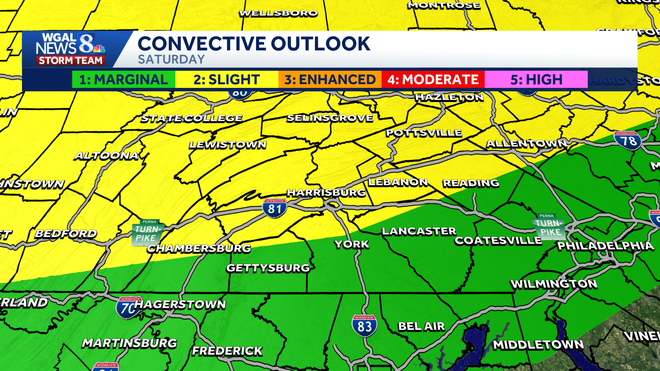
The Storm Prediction Center has placed areas generally north of Route 30 in a Slight Risk for severe weather, a Level 2 out of 5.
Areas south of Route 30 remain in a Marginal Risk, a Level 1 out of 5.
Main threats
Some storms could become strong and produce:
Damaging wind gustsLarge hailFrequent lightningBrief heavy rain
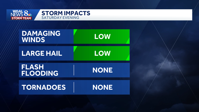
There is currently no threat of flash flooding or tornadoes.
The WGAL News 8 Storm Team will continue to monitor conditions and provide updates as they become available.
Did you capture a moment that you would like to share with News 8? Send us your photos or videos at https://www.wgal.com/upload.