
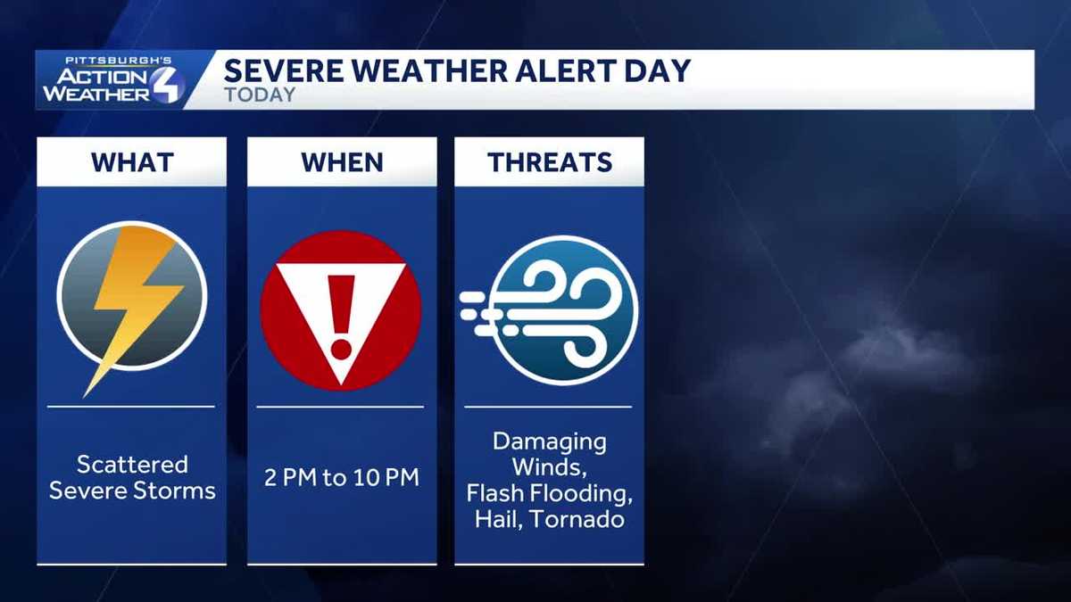
Severe Weather Alert Day: Scattered strong storms for western PA
Storms start firing after 2 p.m. with the threat lingering through 9 p.m.
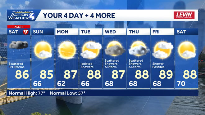
250. SUSAN SHAPIRO IN PHILADELPHIA, PENNSYLVANIA. PITTSBURGH’S ACTION WEATHER NOW A SEVERE WEATHER ALERT DAY. SO THAT MEANS WE REALLY NEED TO BRING IN JILL SZWED WITH OUR CERTIFIED MOST ACCURATE FORECAST. I KNOW IT’S KIND OF IT’S GOING TO BE KIND OF SWITCHING GEARS TOWARDS THE BACK OF THE DAY, IT’S A VERY BUSY WEEKEND. THERE ARE A LOT OF BIG EVENTS GOING ON, NOT JUST IN PITTSBURGH, BUT ALL ACROSS WESTERN PENNSYLVANIA, A LOT OF GRADUATIONS YESTERDAY. SO HERE’S WHAT YOU NEED TO KNOW AS YOU’RE GETTING OUT AND ABOUT SO YOU CAN STAY WEATHER AWARE AND SAFE AS WE GO THROUGH THE SEVERE WEATHER ALERT DAY. SCATTERED SEVERE RISK AREA WIDE ACROSS WESTERN PENNSYLVANIA. DAMAGING WINDS ARE LEADING THREAT BUT ALSO SOME FLASH FLOODING THAT IS GOING TO BE LOCALIZED. SO NOT EVERYBODY DEALING WITH THAT HEAVY RAIN, BUT WHERE IT RAINS, IT MAY POUR. AS WE GO THROUGH THE AFTERNOON. WE ALSO CAN’T OVERLOOK THE LARGE HAIL AND TORNADO RISK, ALTHOUGH THOSE ARE A LESSER THREAT ON THE SEVERE WEATHER ALERT DAY. GETTING SOME UPDATES IN ON FUTURECAST HAVE ALREADY TRACKED A FEW SPRINKLES, EVEN SOME BRIEF SHOWERS SO FAR THIS MORNING WE COULD SEE A LITTLE BIT MORE OF THAT ACTION AS WE GO INTO THE AFTERNOON, BUT THOSE OF YOU THAT STAY RELATIVELY QUIET AND EVEN POP OUT TO A LITTLE BIT OF SUNSHINE, THAT’S WHERE THE ATMOSPHERE COULD GET SUPER CHARGED. AS WE GET SET FOR THE SEVERE WEATHER ALERT DAY. SO SOME SCATTERED STORMS FILING IN AS EARLY AS ABOUT TWO, 3:00 THIS AFTERNOON. WE’LL MONITOR THIS LINE THAT IS FORMING NOW A LITTLE BIT DELAYED ITS ONSET, GIVING THE ATMOSPHERE SOME TIME TO AGAIN CHARGE UP SOME OF THOSE STORMS. HERE’S BETWEEN ABOUT FIVE AND 6:00. THAT ACTIVITY TRACKING THROUGH BEAVER, SOUTHERN PARTS OF BUTLER, ALSO ALONG INDIANA, INTO PARTS OF ARMSTRONG AND INDIANA COUNTIES THAT SHOULD BE DROPPING INTO THE CITY OF PITTSBURGH CLOSER TO DINNERTIME. SO A HEADS UP FOR THOSE OF YOU HEADING TO NIGHT TWO OF MORGAN WALLEN. IF YOU’RE GOING TO BE DOWNTOWN FOR PITTSBURGH PRIDE OR THE THREE RIVERS ARTS FESTIVAL, IT’S GOING TO START TO GET A LITTLE BIT HAIRY BETWEEN ABOUT FIVE AND 7 P.M. NOW, WE COULD SEE THIS LINE ACTUALLY BREAK APART, AND WITH THAT, WE WOULD SEE TWO CLUSTERS OF THUNDERSTORMS THAT COULD REALLY PACK A PUNCH. AS ACTIVITY CONTINUES TO TRACK TOWARDS I-70. AS THE SUN SETS. OF COURSE, LOSING THAT INSTABILITY, THAT STORM ENERGY. SO WITH THAT, WE’LL SEE THE STORMS BREAKING DOWN. BUT IT WON’T BE ALL QUIET THROUGH THE OVERNIGHT. SOME AREAS OF FOG WILL FORM, SO COULD BE A LITTLE BIT TRICKY. IF YOU’RE OUT TO CHURCH TOMORROW MORNING OR YOU HAVE EARLY BREAKFAST PLANS TODAY, SEVERE WEATHER ALERT DAY PASSING SHOWER THIS MORNING. THE ALERT DAY IS PRIMARILY FOR THOSE STRONGER STORMS INTO THE AFTERNOON. EARLY PARTS OF THE EVENING STILL VERY WARM OR HUMID. 86 AFTER THE FOG AND CLOUDS IN THE MORNING WILL BRING BACK SUNSHINE FOR YOUR SUNDAY. YOU’LL NOTICE IN YOUR 4-DAY PLUS 4 MORE FORECAST SAYS A WHOLE LOT OF SUMMER WITH TEMPERATURES WILL BE IN THE MID TO EVEN UPPER 80S, GETTING CLOSE TO 90 TOWARDS THE MIDDLE PART OF THE WEEK. IT’S STARTING TUESDAY THAT OUR AFTERNOONS COULD GET A LITTLE BIT UNSETTLED AS WE’LL DODGE A FEW SHOWERS AND EVEN AN ISOLATED THUNDERSTORM OVER THE PAST HOUR. AND EVEN REALLY SINCE WE CAME ON THE AIR 5 A.M. THIS MORNING, WE’RE TRACKING A FEW OF THOSE SHOWERS. THINGS SEEM TO BE CALMING DOWN, AT LEAST RIGHT NOW, BUT SO WE COULD POP A SHOWER OR TWO. TEMPERATURES AROUND 70 IN MOST NEIGHBORHOODS. IN FACT, 71 RIGHT NOW IN PITTSBURGH. AS YOU GO OVER THE NEXT 12 HOURS, AGAIN, WE GO TO THAT SEVERE WEATHER ALERT DAY, ESPECIALLY AFTER 3:00, 4:00, PRIMARILY NORTH OF THE CITY BETWEEN NOW AND THEN. PLENTY OF TIME TO WARM. GETS BREEZY TO WITH THOSE WINDS COMING IN OUT OF THE WEST SOUTHWEST. AND WE’LL KEEP THAT ALERT DAY GOING THROUGH ABOUT 9:00, 10:00 THIS EVENING. SO AGAIN, NOT ONLY SEVERE WEATHER BUT ALSO FLASH FLOODING WILL BE A CONCERN ON THE SEVERE WEATHER ALERT DAY. THEN TOMORROW WE START OFF WITH FOG AND WITH SUNSHINE. SHOULD BE A NICE DAY AS WE WRAP UP THE FIRST WEEKEND OF THE THREE RIVERS ARTS FESTIVAL, 85 DEGREES POOL DAY ON MONDAY, 87 TONS OF SUNSHINE. THEN WE GET INTO THOSE SHOWER AND STORM CHANCES THAT WILL BE ON THE REGULAR, PRIMARILY INTO THE AFTERNOON STARTING ON TUESDAY. THAT COULD EXPAND INTO FLOODING AT THIS POINT. HARD TO SAY WHICH DAY WOULD BE A LITTLE BIT MORE UNSETTLED THROUGH THE AFTERNOON, SO WE’LL BE MONITORING THAT FINE TUNING IT AS WE GO THROUGH NEXT WEEK. BUT WELCOME TO SUMMERTIME HERE IN WESTERN PENNSYLVANIA. YOU SEE, IN THE 80S IS NOT BAD. IT’S BEEN A LONG TIME COMING FOR US. I KNOW, RIGHT, IT’S HEATING UP FAST. SO YOU GOT TO FIND A WAY TO STAY COOL, WHETHER IT’S BY T
Severe Weather Alert Day: Scattered strong storms for western PA
Storms start firing after 2 p.m. with the threat lingering through 9 p.m.

Updated: 9:28 AM EDT Jun 6, 2026
This is a busy weekend around western Pennsylvania with the Three Rivers Arts Festival, the night two of Morgan Wallen, Pittsburgh Pride events, along with graduations and parties. Here is a breakdown of what you can expect and when on this Severe Weather Alert Day.Severe Weather Alert Day timing and threatsToday begins with a passing showers before noon. Any clearing – no matter how brief – will help to charge the atmosphere for severe weather. Scattered strong and severe thunderstorms will develop as early as 2 p.m. between I-80 and US-422. The line or cluster of storms will march southward; likely impacting the immediate Pittsburgh area between 4 p.m. and 6 p.m. Activity will die down after 9 p.m. Damaging winds are the primary storm threat. Localized flash flooding will also be a concern. The tornado risk is low, but will still need to be monitored. If a storm were to spin out a tornado, it would be likely before 5 p.m. before individual storms become more linear.Drier end the weekendRain showers look to taper off overnight with patchy dense fog forming. Outside of an isolated shower, Sunday will be humid with the return of more sunshine.More summer heat next weekHigh pressure starts to nose back into the area on Monday. Temperatures will remain in the mid to upper 80s throughout much of next week. There will be a chance for rain showers from Tuesday through Thursday. Those showers are likely pop up in the afternoon each day.TODAY – Severe Weather Alert Day: Scattered severe thunderstorms after 2 p.m. More humid and very warm. High: 86°.TONIGHT: Storms fizzle after 10 p.m. Isolated late night shower then areas of dense fog. Low: 66°.SUNDAY: Morning fog and clouds, afternoon sunshine. High: 85°, low: 62°.MONDAY: Sunny and warmer. High: 87°, low: 66°.TUESDAY: Muggy with isolated showers. High: 88°, low: 68°.
PITTSBURGH —
This is a busy weekend around western Pennsylvania with the Three Rivers Arts Festival, the night two of Morgan Wallen, Pittsburgh Pride events, along with graduations and parties. Here is a breakdown of what you can expect and when on this Severe Weather Alert Day.
Severe Weather Alert Day timing and threats
Today begins with a passing showers before noon. Any clearing – no matter how brief – will help to charge the atmosphere for severe weather.
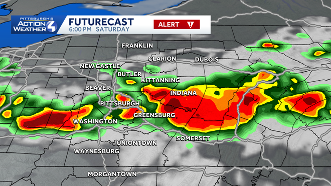
Scattered strong and severe thunderstorms will develop as early as 2 p.m. between I-80 and US-422. The line or cluster of storms will march southward; likely impacting the immediate Pittsburgh area between 4 p.m. and 6 p.m. Activity will die down after 9 p.m.
Hearst OwnedHearst
A line of thunderstorms will pack a punch with damaging winds and flash flooding concerns through sundown.
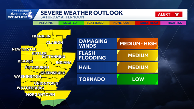
Damaging winds are the primary storm threat. Localized flash flooding will also be a concern. The tornado risk is low, but will still need to be monitored. If a storm were to spin out a tornado, it would be likely before 5 p.m. before individual storms become more linear.
Hearst OwnedHearst
Damaging winds and flash flooding are today’s top storm threats.
Drier end the weekend
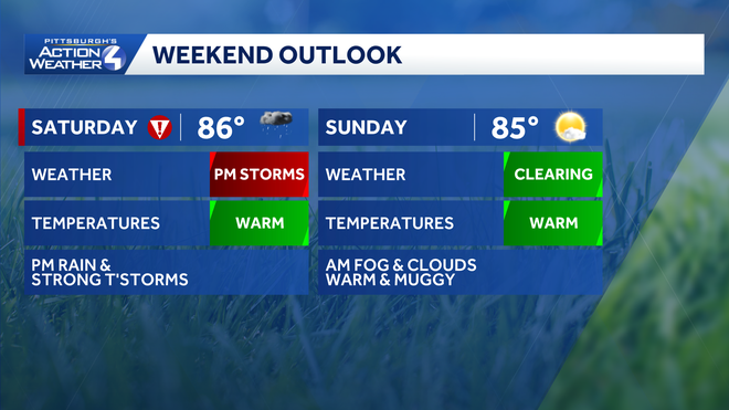
Rain showers look to taper off overnight with patchy dense fog forming. Outside of an isolated shower, Sunday will be humid with the return of more sunshine.
Hearst OwnedHearst
Stormy today; sunshine tomorrow for western PA.
More summer heat next week
High pressure starts to nose back into the area on Monday. Temperatures will remain in the mid to upper 80s throughout much of next week. There will be a chance for rain showers from Tuesday through Thursday. Those showers are likely pop up in the afternoon each day.
Hearst OwnedHearst
The summer heat continues next week. The pattern will turn more unsettled starting on Tuesday.
TODAY – Severe Weather Alert Day: Scattered severe thunderstorms after 2 p.m. More humid and very warm. High: 86°.
TONIGHT: Storms fizzle after 10 p.m. Isolated late night shower then areas of dense fog. Low: 66°.
SUNDAY: Morning fog and clouds, afternoon sunshine. High: 85°, low: 62°.
MONDAY: Sunny and warmer. High: 87°, low: 66°.
TUESDAY: Muggy with isolated showers. High: 88°, low: 68°.