
Heat, humidity, and storm chances for South-Central Pennsylvania
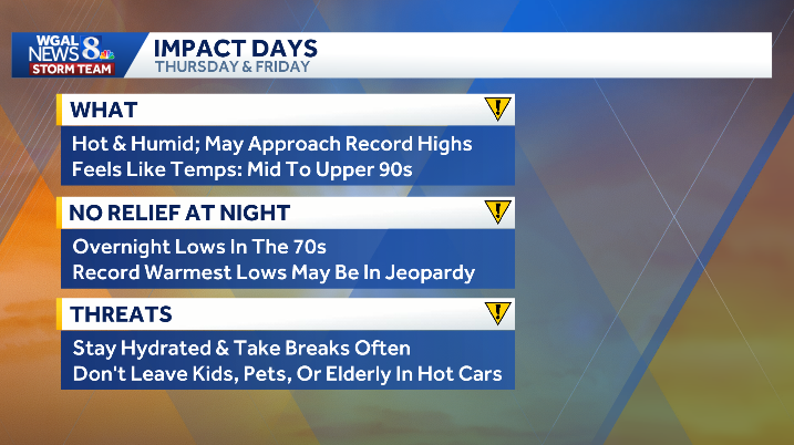
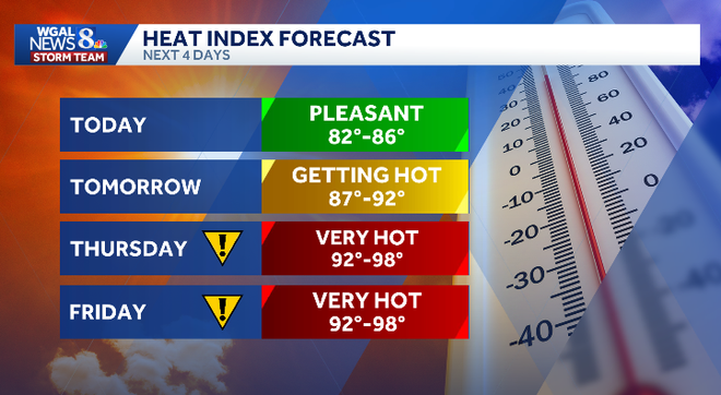
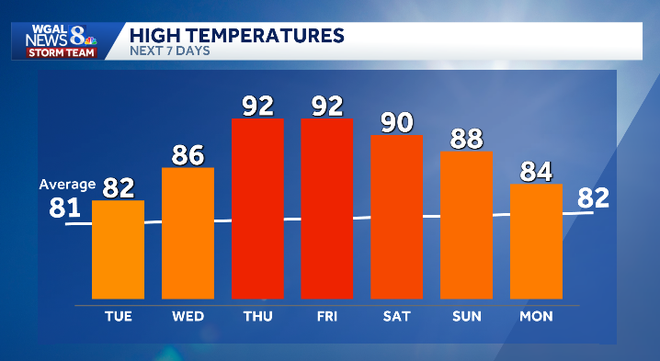
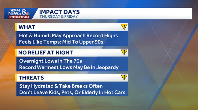
TEAM FORECAST WITH METEOROLOGIST MARYELLEN PANN. AS WE CHECK OUT YOUR WEATHER HEADLINES, IT IS GOING TO BE A PLEASANT, COMFORTABLE DAY TODAY, DESPITE A LOT OF CLOUD COVER. WE’LL SEE SOME PEEKS OF SUNSHINE AS WE HEAD THROUGH THE DAY, AND THEN THE CLOUDS WILL THICKEN BACK UP. SHOWER AND STORM CHANCES RETURN TOMORROW AND THE HEAT AND HUMIDITY IS REALLY GOING TO SOAR. WE’RE TALKING 90S FOR HIGHS AND DEW POINT READINGS, CLIMBING INTO THE 70S. SO COMBINED THAT’S GOING TO LEAD TO SOME HEAT INDEX VALUES IN THE MID TO UPPER 90S. SO WE’VE MADE IT AN IMPACT DAY BOTH THURSDAY AND FRIDAY BECAUSE OF THOSE HEAT INDEX NUMBERS IN THE MID TO UPPER 90S. I MENTIONED WE COULD ALSO EVEN CHALLENGE SOME RECORD HIGHS AND OVERNIGHT LOWS. AND WE DON’T GET MUCH RELIEF AT ALL FROM THE HEAT EVEN IN THE OVERNIGHT PERIOD, BECAUSE TEMPERATURES WILL ONLY DROP TO THE LOW 70S. SO WE WANT TO MAKE SURE IF YOU’RE SENSITIVE TO HEAT AND HUMIDITY, YOU STAY HYDRATED, TAKE BREAKS OFTEN IF YOU HAVE TO WORK OUTSIDE AND THEN KEEP AN EYE ON THE KIDS PETS, DON’T LEAVE THEM IN THE CAR. EVEN WITH THE CRACKED WINDOWS AND ALSO THE ELDERLY. AND LOOKING OUTSIDE. RIGHT NOW, WE DO HAVE THIS BLANKET OF CLOUDS IN YORK AND YOU CAN SEE TEMPERATURES SITTING AT 63. THE DEW POINT, THOUGH, MORE IMPORTANTLY, IS AT 49. SO IT IS VERY COMFORTABLE OUTSIDE. WE HAVE DEW POINTS IN THE 40S IN CARLISLE, GETTYSBURG, ALSO IN HARRISBURG, ELSEWHERE IN THE 50S. SO TAKE ADVANTAGE OF THIS PLEASANT WEATHER WHILE YOU CAN. WE ARE SITTING IN THE LOW 60S, OUR COOLER SPOTS OFF TO THE EAST, WHERE WE HAD SOME CLEARING IN THE 50S THERE IN LANCASTER AND READING AND YOUR NEWS EIGHT STORM TEAM FORECAST TODAY CALLS FOR THOSE TEMPERATURES TO CLIMB INTO THE LOW 80S. WE WILL SEE SOME BREAKS IN THE CLOUD COVER MID DAY BEFORE THE CLOUDS THICKEN BACK UP OVERNIGHT. TONIGHT OVERCAST SKIES AND WE’LL SEE SHOWERS MOVING IN LATER TONIGHT TOWARDS THE MORNING HOURS. LOWS IN THE UPPER 60S. TOMORROW MOSTLY CLOUDY SHOWERS IN THE MORNING AND THEN WE’LL WATCH FOR SOME SHOWERS AND A FEW RUMBLES OF THUNDER IN THE AFTERNOON TO DEVELOP TEMPERATURES IN THE MID 80S, BUT WITH THE HUMIDITY IT WILL FEEL CLOSER TO 90 DEGREES IN YOUR WEATHER AND HEALTH CHECK. TREE AND GRASS POLLEN IS STILL RUNNING MODERATELY. AIR QUALITY IS MODERATE FOR OZONE, AND THE UV INDEX IS MODERATE WITH THE BURN TIME OF 30 MINUTES. SO HIGH PRESSURE SITTING JUST OFF THE DELMARVA COAST IS BRINGING WINDS IN FROM THE SOUTH. AND THE CLOUDS THAT YOU SEE THERE. WE’LL GET SOME BREAKS JUST OFF TO THE WEST THERE, AND THEN THE CLOUDS WILL THICKEN UP AS WE HEAD TOWARDS THE LATE AFTERNOON INTO THE EARLY EVENING, WARM FRONT WILL COME THROUGH OVERNIGHT TONIGHT, BRINGING SOME SHOWERS IN THE MORNING, AND THEN WE’LL WATCH FOR A RUMBLE OR TWO IN THE AFTERNOON. A COUPLE MORE SHOWERS LATER IN THE DAY, BUT THERE WILL BE SOME DRY HOURS TO GET OUTSIDE. IT’S JUST GOING TO BE WARM AND HUMID ON THURSDAY WITH THE HEAT AND HUMIDITY COMBINED AND A LITTLE DISTURBANCE COMING THROUGH, THAT’S GOING TO LEAD TO SOME SHOWERS AND STORMS IN THE AFTERNOON AND THE EVENING HOURS, SO CERTAINLY WANT TO KEEP AN EYE TO THE SKY IF YOU’RE GOING TO BE OUT ON THURSDAY. AND TAKE IT EASY TOO. AS I MENTIONED, WITH THE HEAT AND HUMIDITY BUILDING, IT’S GOING TO BE HOT THURSDAY AND FRIDAY, MAKING BOTH DAYS IMPACT DAYS BECAUSE WHEN YOU FACTOR IN THE HUMIDITY, IT’S GOING TO FEEL EVEN HOTTER THAN THE ACTUAL AIR TEMPERATURE. BETTER CHANCE FOR STORMS ON FRIDAY BECAUSE THE HEAT AND HUMIDITY AND A COLD FRONT COMING IN THAT WILL TRIGGER THE POSSIBILITY OF SOME STORMS. WE’RE GOING TO WATCH FOR THE THREAT FOR SEVERE STORMS. WE’RE NOT OUT JUST YET, BUT WE COULD BE. THE WEEKEND IS DRIER NOW AND TEMPERATURES STILL WARM NEAR 90 DEGREES. BUT WE DO TREND INTO THE L
Heat, humidity, and storm chances for South-Central Pennsylvania

Updated: 9:03 AM EDT Jun 9, 2026
Hot, increasingly humid weather returns to South-Central Pennsylvania on Thursday and Friday, with highs in the low 90s and feels-like temperatures in the mid to upper 90s. The WGAL News 8 Storm Team is also monitoring the potential for severe weather on both days.Thursday and Friday are Impact Days, meaning the weather could disrupt your normal daily schedule or routine.Heat peaks Thursday and FridayThursday is expected to be the hottest day of the week.Highs: low 90sFeels-like temperatures: mid to upper 90sOvernight lows: staying above 70 degreesRecord heat may be challengedThursday’s record high: 96 set in 1911Friday’s record high: 92 set in 2017Morning low records could also be challengedThunderstorm chances increaseAfternoon and evening thunderstorms become more likely both daysFriday has the greater storm threat as a cold front approachesThe Storm Prediction Center has placed the Susquehanna Valley in a Marginal RiskSevere weather threatRisk level: 1 out of 5Main threats: isolated damaging wind gusts and large hailGreater severe weather risk is expected Friday afternoon and eveningSOUTH-CENTRAL PA WEATHER RESOURCES: INTERACTIVE RADAR | ACTIVE WEATHER ALERTS | CURRENT CONDITIONS | HOURLY FORECAST | 10-DAY FORECAST | WEEKEND FORECAST | MAP ROOM | DOWNLOAD THE APP | WEATHER EMAILS
Hot, increasingly humid weather returns to South-Central Pennsylvania on Thursday and Friday, with highs in the low 90s and feels-like temperatures in the mid to upper 90s.
The WGAL News 8 Storm Team is also monitoring the potential for severe weather on both days.
Thursday and Friday are Impact Days, meaning the weather could disrupt your normal daily schedule or routine.
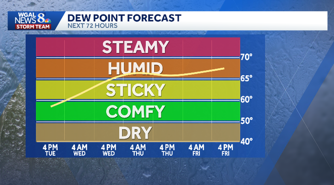
Heat peaks Thursday and FridayThursday is expected to be the hottest day of the week.Highs: low 90sFeels-like temperatures: mid to upper 90sOvernight lows: staying above 70 degrees
Record heat may be challengedThursday’s record high: 96 set in 1911Friday’s record high: 92 set in 2017Morning low records could also be challengedThunderstorm chances increaseAfternoon and evening thunderstorms become more likely both daysFriday has the greater storm threat as a cold front approachesThe Storm Prediction Center has placed the Susquehanna Valley in a Marginal Risk
Severe weather threat
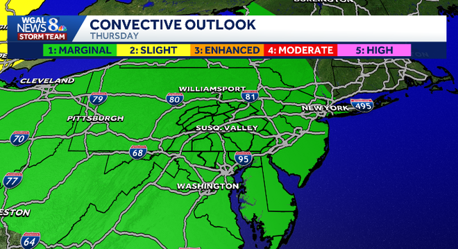
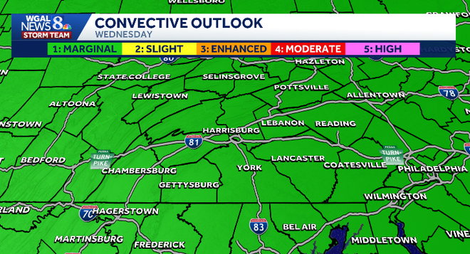
Risk level: 1 out of 5Main threats: isolated damaging wind gusts and large hailGreater severe weather risk is expected Friday afternoon and evening
SOUTH-CENTRAL PA WEATHER RESOURCES: INTERACTIVE RADAR | ACTIVE WEATHER ALERTS | CURRENT CONDITIONS | HOURLY FORECAST | 10-DAY FORECAST | WEEKEND FORECAST | MAP ROOM | DOWNLOAD THE APP | WEATHER EMAILS