
SHORT TERM FORECAST
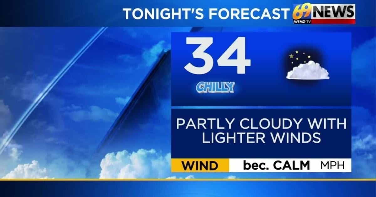
TONIGHT: Partly cloudy and chilly as winds diminish. Low: 34
SUNDAY: Mostly sunny and seasonable. High: 60
SUNDAY NIGHT: Partly cloudy and cool. Low: 37
THE BIG PICTURE
Saturday was a pretty seasonable day with a mix of sun and clouds and afternoon high temperatures in the upper 50s to around 60 degrees. Winds out of the northwest were still a bit gusty at times up to near 30mph, but it certainly wasn’t as windy as Friday was. The weekend will finish off sunny and dry with a seasonable day expected Sunday as high temperatures climb to around 60 degrees. Winds will be lighter Sunday as well. Some clouds will increase at the start of next week as a couple waves of energy, one to our north and one to our south, track through. The two features try to phase but it never truly happens meaning the large majority of the area remains dry. We’ll see more seasonable high temperatures around 60 degrees for the first half of the week as the breeze becomes a bit noticeable again. Another weak disturbance will track through Wednesday night possibly sparking a few showers. In the wake of that system, high temperatures turn a little cooler for the latter part of next week with some gusty winds on occasion but otherwise partly sunny skies.
FORECAST DETAILS
TONIGHT
As high pressure builds closer to the region from our west tonight, look for breezes to gradually diminish and eventually become calm. Skies will be partly cloudy and overnight low temperatures will drop to some rather chilly levels in the low and mid 30s. Areas of frost will be possible and the growing season is technically still going for southern New Jersey so the National Weather Service has placed Burlington, Camden, and Gloucester Counties under a Frost Advisory for the overnight. Also, before going to bed tonight, don’t forget to set those clocks back one hour as Daylight Saving Time officially ends at 2am Sunday. You’ll get an extra hour of sleep tonight, but, moving forward we’re also going to be seeing the sun setting prior to 5pm for a while. One final reminder…be sure to check the batteries in your smoke detectors and carbon monoxide detectors as well.
SUNDAY AND MONDAY
High pressure moves atop the region for Sunday leading to lighter winds and mostly sunny skies. Afternoon high temperatures should be fairly seasonable and pleasant for this time of the year topping out around 60 degrees. On Monday, we’ll see a little more cloud cover as a frontal boundary tracks by to our north and a wave of low pressure slides off the North Carolina and Virginia coastline. The two features try to merge a little, but it never truly comes to fruition, meaning most of any showers with the northern system stay away north while showers with the southern low stay away south. It’s possible a few showers are at least able to work across southern New Jersey and Delaware Monday, but most should stay dry. The further north and west one travels from the Lehigh Valley the more sun you’ll see while the further south and east you go, the more cloud cover. High temperatures Monday will remain seasonable around 60 degrees.
ELECTION DAY TUESDAY
We’re “electing” for some nice weather for in-person voting on Tuesday, although those brisk northwest breezes will return. High temperatures remain the same, mostly around 60 degrees, as high pressure noses in from our west leading to mostly sunny skies. Look for winds to be a little gusty at times sustained around 10-20mph.
WEDNESDAY THROUGH FRIDAY
The quiet start to November likely lasts through all of next week, with just a couple weak disturbances tracking through occasionally. Look for more partly sunny skies Wednesday and yet again seasonable high temperatures around 60 degrees with more brisk winds. Besides a spotty shower Wednesday night thanks to a weak cold front moving in from our north and west, expect partly sunny skies, brisk winds, and dry conditions to take us through Thursday and Friday. High temperatures will turn a little cooler for the latter part of the week dropping back into the mid and upper 50s. Another front is expected to approach the region Friday night bringing another chance for some showers.
TRACK THE WEATHER:
LINKS: HOUR BY HOUR | RADAR | TRAFFIC