
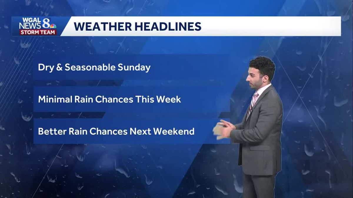
Seasonable and dry Sunday, mainly dry through the work week across south-central Pennsylvania
Partly cloudy and chillier heading through the overnight period. Cool, calm, and crisp conditions for Sunday afternoon with highs in the low 60s. We stay dry through the majority of the work week, but better rain chances arrive later next weekend.
SEASONABLE SUNDAY AS WE GET INTO TOMORROW AFTERNOON. I THINK THE THREE C’S HERE WOULD BE COOL, CALM AND COMFY AS WE GET INTO THE AFTERNOON. CERTAINLY NOT GOING TO BE AS WINDY AS HIGH PRESSURE BUILDS IN OVERHEAD. THAT’S GOING TO HELP RELAX WINDS AS WE GET INTO THE DAY TOMORROW. MINIMAL RAIN CHANCES THOUGH AS WE GET INTO THIS WEEK. BUT THEN AS WE GET INTO NEXT WEEKEND, THE BETTER OF THOSE RAIN CHANCES START TO COME INTO THE PICTURE, ESPECIALLY AS WE GET INTO FRIDAY, SATURDAY, SUNDAY RANGE. WE’RE STILL TRACKING THAT AS WE GET INTO NEXT WEEK. FORECAST FOR THE REST OF THE NIGHT. TONIGHT PARTLY CLOUDY CONDITIONS. CERTAINLY FEELING CHILLIER OUT THERE INTO THE MID TO UPPER 30S WITH THOSE LIGHTER WINDS OUT OF THE WEST. THEY’RE VERY LIGHT AND VARIABLE IN NATURE. THEN FOR TOMORROW MORNING, MOSTLY SUNNY START. IT’S A LITTLE BIT CHILLY AS WELL AND SOME CALM WINDS OUT OF THE NORTHWEST AT ABOUT FIVE MILES PER HOUR, 44 TO 48 DEGREES. AND THEN AS WE GET INTO THE AFTERNOON, PARTLY SUNNY, CALMER AND MORE COMFY. IT WILL BE A PLEASANT DAY WITH LIGHT WINDS OUT OF THE SOUTHEAST, 58 TO 62 DEGREES FOR YOUR TEMPERATURE RANGE. SO IF YOU’RE HEADED TO THE GREEK FOOD BAZAAR, IT’S GOING TO BE A LOVE. HEY, IF YOU EVER HAD SOME OF THE GREEK FOOD, IT’S INCREDIBLE. WHEN I WENT TO THE THE GREEK FEST. OH, AMAZING FOOD. YOU DEFINITELY GOT TO GO AND TRY OUT SOME OF THE GREEK FOOD FROM 11 A.M. UNTIL 5 P.M. YOU CAN SEE MOSTLY SUNNY, COOL, CALM AND CRISP THROUGHOUT THE DAY AND MOSTLY CLEAR AS WE AS WE END OUT THE DAY FOR TOMORROW. NOW, IF YOU STILL HAVE TO GET THE LEAF CLEAN OR THE LEAVES DONE, IF YOU WANT TO TAKE SOME TIME TO CLEAN UP SOME OF THOSE LEAVES YET SUNDAY AND MONDAY ARE GOING TO BE YOUR BETTER OF THE TWO DAYS OR THE THREE DAYS. I SHOULD SAY I RATED TUESDAY AS FAIR BECAUSE IT DOES BECOME A LITTLE BIT MORE BREEZY OR INCREASINGLY BREEZY, SO IT MIGHT BE A LITTLE BIT OF A NUISANCE OUT THERE AS WE GET INTO TUESDAY. NOW IT IS DRY, I WILL SAY MOSTLY SUNNY, BUT IT’S JUST THAT BREEZE, YOU KNOW, YOU’RE GOING TO RAKE YOUR LEAVES UP INTO A PILE AND THEN WHAT’S GOING TO HAPPEN? IT’S GOING TO BLOW AWAY. AND THERE GOES ALL YOUR WORK, RIGHT? BECAUSE THAT’S AT LEAST THAT’S HOW IT WORKS FOR ME ANYWAY. BUT ANYWAY, SO THAT’S YOUR LEAF CLEANUP FORECAST. BUT NOVEMBER PREVIEW. WE’RE INTO THE NOVEMBER 1ST ALREADY. CAN YOU, CAN YOU ALREADY BELIEVE IT’S ALREADY NOVEMBER? 60 DEGREES IS THE AVERAGE HIGH FOR THIS TIME OF YEAR. AVERAGE LOW IS RIGHT AROUND 40 DEGREES. BUT LOOK, ONCE WE END OUT THE MONTH HIGH TEMPERATURES OR IN TERMS OF THE AVERAGE HIGH TEMPERATURES RIGHT AROUND TO THE UPPER 40S AND RIGHT DOWN TO THAT FREEZING POINT, AS WE GET INTO AVERAGE LOWS FOR THE END OF NOVEMBER, MADE IT TO 61 TODAY AT THE AIRPORT, 60 DEGREES. THAT’S THE USUAL HIGH FOR THIS TIME OF THE YEAR. SO WE’RE RIGHT AROUND PAR IN TERMS OF BOTH HIGHS AND LOWS. JUST A SIX DEGREE ABOVE AVERAGE DIFFERENCE FOR LAST NIGHT’S LOW TEMPERATURES INTO THE 40S RIGHT NOW. GOT 38 DEGREES IN SELINSGROVE. STORM TEAM LIVE RADAR NETWORK. ALL IS QUIET RIGHT NOW. AND THAT’S ALL THANKS TO HIGH PRESSURE THAT’S BUILDING IN OVERHEAD. THE SUSQUEHANNA VALLEY. AND THAT’S GOING TO PERSIST AS WE GET INTO REALLY NOT NOT ONLY THE SECOND HALF OF THE WEEKEND, BUT ALSO INTO OUR MONDAY A LITTLE BIT, BUT I WILL SAY SOME SOME NEW DATA IS STARTING TO COME IN AS WE GET INTO OUR MONDAY. I AM SEEING A VERY LIGHT SHOWER CHANCE AS WE GET INTO OUR MONDAY, BUT VERY VERY VERY SLIM AS WE GET INTO THE AFTERNOON AND THE EVENING. SO FOR YOUR MONDAY, INCREASING CLOUD COVER, THEN BREEZY AND SEASONABLE FOR TUESDAY AND WEDN
Seasonable and dry Sunday, mainly dry through the work week across south-central Pennsylvania
Partly cloudy and chillier heading through the overnight period. Cool, calm, and crisp conditions for Sunday afternoon with highs in the low 60s. We stay dry through the majority of the work week, but better rain chances arrive later next weekend.

Updated: 11:34 PM EDT Nov 1, 2025
Skies will partially clear from clouds late thanks to building high pressure, leaving us with partly cloudy skies tonight with light & variable winds. It will be chillier with lows in the upper 30s.As high pressure builds east Sunday, conditions will be cool, calm, & comfy. Look for partly to mostly sunny skies, with highs near 60.As low pressure lifts northeast just off the coast, we will see an uptick in cloud cover for Monday. There may be an isolated shower in far southeastern areas Monday night, otherwise most of the area is dry. Winds will pick up again with gusts 20 to 30 mph. Temperatures stay steady around 60 degrees.The rest of the week is mainly dry, except for a few shower chances on Thursday.Better rain chances arrive late Friday into Saturday next weekend.Have a great rest of your night!~ Ryan
Skies will partially clear from clouds late thanks to building high pressure, leaving us with partly cloudy skies tonight with light & variable winds. It will be chillier with lows in the upper 30s.
As high pressure builds east Sunday, conditions will be cool, calm, & comfy. Look for partly to mostly sunny skies, with highs near 60.
As low pressure lifts northeast just off the coast, we will see an uptick in cloud cover for Monday. There may be an isolated shower in far southeastern areas Monday night, otherwise most of the area is dry. Winds will pick up again with gusts 20 to 30 mph. Temperatures stay steady around 60 degrees.
The rest of the week is mainly dry, except for a few shower chances on Thursday.
Better rain chances arrive late Friday into Saturday next weekend.
Have a great rest of your night!
~ Ryan