
Severe Thunderstorm Warning expires for parts of Western Pa.
A soaking rain through Monday prompts an Impact Day.
250 I’M SCOTT MCDONNELL AT ACADIA NATIONAL PARK IN MAINE. TURNING NOW TO PITTSBURGH’S ACTION WEATHER METEOROLOGIST JILL SZWED YOUR CERTIFIED MOST ACCURATE FORECAST. GOOD NEWS, GOOD WEEKEND. BAD NEWS MONDAY. I KNOW RIGHT, BUT WE’RE NOT GOING TO WORRY ABOUT MONDAY. IT’S A GORGEOUS WEEKEND HERE ACROSS WESTERN PENNSYLVANIA. GREAT TO DO A LITTLE EXPLORING OR TAKING A LOT OF BIG EVENTS GOING ON THIS WEEKEND AS WE CONTINUE WITH THIS JUNETEENTH HOLIDAY WEEKEND, AN OUTSIDE CHANCE OF A PASSING SHOWER THIS AFTERNOON, MAYBE A RUMBLE OF THUNDER. BUT FOR THE MOST PART, THE MAJORITY OF WESTERN PA WE’RE KEEPING IT DRY, KEEPING IT GOOD ALL WEEKEND LONG WITH TEMPERATURES CLOSING IN ON 80 FOR FATHER’S DAY TOMORROW. LOVE TO SEE IT. TONS OF BLUE SKY OVER OUR CITY HERE THIS MORNING AS WE GO THROUGH THE AFTERNOON, A FEW CLOUDS WILL POP UP, PROVIDING A LITTLE BIT OF DECORATION, BUT CERTAINLY A NICE START TO THE DAY HERE AS WE GEAR UP FOR THE WEEKEND. TEMPERATURES EQUALLY AS NICE. JUST ABOUT EVERYBODY IN THE 70S THIS AFTERNOON A LITTLE CLOSER TO 80 FOR SPOTS LIKE BEAVER, EVEN HERE IN PITTSBURGH, MONROEVILLE TO 78 FOR UNIONTOWN, MID 70S. WASHINGTON, INDIANA. ALSO BUTLER UP ALONG I-80. YOUR TEMPERATURES WILL BE CLOSING IN ON 70 THIS AFTERNOON. AS I MENTIONED, THERE’S A SMALL CHANCE I HATE TO EVEN MENTION IT, BUT WE DON’T WANT YOU TO GET CAUGHT BY A SHOWER OR RUMBLE OF THUNDER A LITTLE LATER ON. TODAY. COULD SEE SOME ACTION AS EARLY AS ABOUT 11:00 NOON. THAT’LL BE CLOSER TO 422, AND I-80 MAY SEE SOME ACTIVITY DROPPING CLOSER TO BEAVER. EVEN HERE IN ALLEGHENY COUNTY AROUND GREENSBURG. AS WE DRAW CLOSER TO DINNER TIME. SO JUST SOMETHING TO BE MINDFUL OF. YOU’LL BE FIRING UP THE GRILL FOR DINNER A LITTLE LATER ON THIS EVENING. OTHERWISE, ACTIVITY WILL FIZZLE AS THE SUN GOES DOWN AND WE’LL KEEP IT DRY TONIGHT AND THROUGHOUT THE DAY. ON FATHER’S DAY TOMORROW. VERY COMFORTABLE. IF YOU HAVE BRUNCH PLANS WITH DAD IN THE MORNING, MAYBE A MORNING TEE TIME. WE START OFF AROUND 6073 BY NOON, 80 WITH INCREASING CLOUDS AS WE GEAR UP FOR THAT DREADED DAY ON MONDAY. BACK TO WORK AFTER A LONG WEEKEND. ALSO BACK TO RAIN CHANCES AND AN IMPACT DAY. LET ME CHECK IT ALL OUT FOR YOU. SO AS WE GO THROUGH THE EVENING HOURS TOMORROW, GET INCREASING CLOUDS FOR YOUR SUNDAY. THIS LATEST ROUND OF FUTURECAST DELAYS THE RAIN JUST A LITTLE BIT. BUT WHAT WE CAN SAY IS IT’S GOING TO BE AFTER DARK AFTER MIDNIGHT THAT WE SEE THAT INITIAL ONSET HERE, 7:00 IN THE MORNING. EVEN SOME LIGHT RAIN COULD CAUSE SOME PROBLEMS ON THE ROADS. IT GETS STEADIER AND HEAVIER AS THE MORNING EVOLVES. THE EXACT TIMING OF THAT WINDOW, THE HEAVIEST RAIN. WE’RE GOING TO CONTINUE TO NAIL THAT DOWN HERE THIS WEEKEND SO YOU CAN PLAN AHEAD. BUT A DECENT SOAKING TO START OFF YOUR MONDAY INTO THE AFTERNOON. THIS SYSTEM IS GOING TO HANG OUT JUST TO OUR SOUTH, AND THAT WILL LEAD TO ONGOING RAIN CONCERNS, POSSIBLY EVEN A FEW THUNDERSTORMS THAT COULD LEAD TO SOME FLOODING ISSUES, A SOAKING INCH OR MORE OF RAIN IS GOING TO FALL ON MONDAY ALONE, SO WE WILL BE MONITORING SOME ISSUES FOR FLOODING, ESPECIALLY IN URBAN AREAS. POOR DRAINAGE, FLOOD PRONE SPOTS AS WE GO THROUGH MONDAY. ONCE WE KNOCK THAT SYSTEM OUT, WE’RE GOLDEN NEXT WEEK TALKING ABOUT A GOOD AMOUNT OF SUNSHINE. TEMPERATURES ARE GOING TO BE GREAT TOO. FOR THE FIRST WEEK OF SUMMER, LOWS IN THE 50S. HIGHS EDGING CLOSER TO 80 DEGREES FOR THE MIDDLE OF NEXT WEEK. WITH THOSE COMFORTABLE MORNINGS. THAT ALSO MEANS HUMIDITY LEVELS WON’T BE TOO BAD. LOOKS TO BE PRETTY DRY TOO. SO A LOT OF SUMMER CAMPS, THE POOLS AS WELL. VERY BUSY NEXT WEEK
Severe Thunderstorm Warning expires for parts of Western Pa.
A soaking rain through Monday prompts an Impact Day.

Updated: 3:56 PM EDT Jun 20, 2026
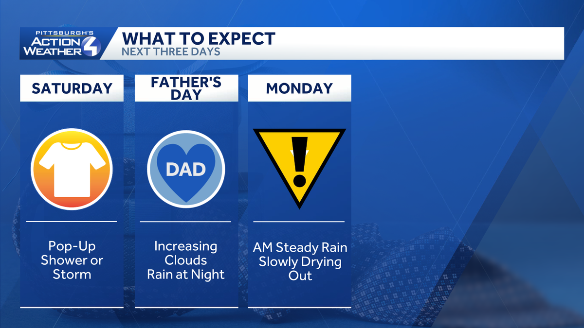
This weekend will be mainly dry and quiet. Rain chances pick up late Sunday night, leading to an Impact Day for Monday with soaking rain and storm chances.Severe Thunderstorm Warning Expires A Severe Thunderstorm Warning previously issued for parts of Western Pennsylvania on Saturday has expired. More: Read the weather alert for your countyInteractive radar: Track snow in your areaLearn how to enable automatic weather alerts on the WTAE mobile app Quiet and mostly dry weekendShowers will be the exception, not the rule this weekend. A weak disturbance could spark a pop-up shower or storm this afternoon, especially near US-422. Any activity that pops up will be brief and very isolated in nature. Cells will fizzle after 8 p.m.Father’s Day will be dry too despite increasing clouds. Temperatures will run a little closer to 80 degrees.Impact Day Monday: Soaking rain, storms possibleThe area-wide rain threat holds off until late Sunday night. Monday is an Impact Day for periods of steady rain and possible storms. The heaviest rain will be falling during the morning commute with showers gradually decreasing once we get past lunch. A few thunderstorms may also be possible as the rain moves through the area.We are expecting about an inch of rain across western PA. Locally higher amounts from pockets of heavy rain and any embedded thunderstorms could show up south of Pittsburgh. Localized flooding may be an issue by late Monday.Seasonal start to summerTomorrow is also the Summer Solstice. Summer officially begins at 4:24 a.m. After Monday’s rain, we remain seasonal through next week with highs in the upper 70s to 80 degrees.TODAY: Partly cloudy, a tad breezy and seasonal. Pop-up shower or storm. High: 78°.TONIGHT: Drying out, mainly clear and pleasant. Low: 59°.SUNDAY: A bit warmer with increasing clouds. Rain arrives overnight. High: 80°, low: 63°.MONDAY – Impact Day: Steady morning rain, lingering afternoon showers with embedded storms. High: 74°, low: 57°.TUESDAY: Partly cloudy and pleasant. High: 77°, low: 56°.
This weekend will be mainly dry and quiet. Rain chances pick up late Sunday night, leading to an Impact Day for Monday with soaking rain and storm chances.
Severe Thunderstorm Warning Expires
A Severe Thunderstorm Warning previously issued for parts of Western Pennsylvania on Saturday has expired.
Quiet and mostly dry weekend
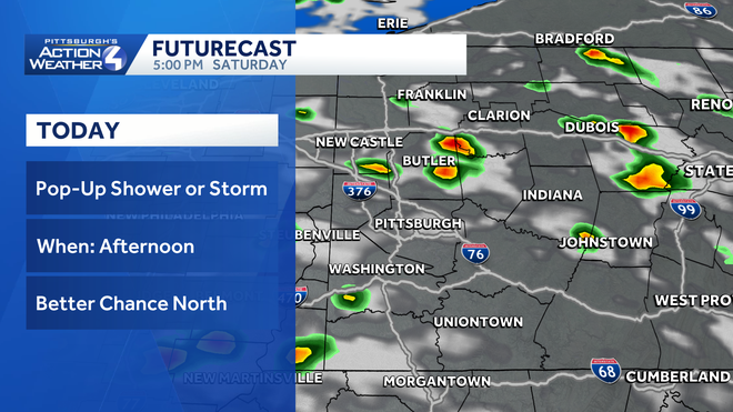
Showers will be the exception, not the rule this weekend. A weak disturbance could spark a pop-up shower or storm this afternoon, especially near US-422. Any activity that pops up will be brief and very isolated in nature. Cells will fizzle after 8 p.m.
Hearst OwnedHearst
Quick passing showers will pop up this afternoon around western PA.
Father’s Day will be dry too despite increasing clouds. Temperatures will run a little closer to 80 degrees.
Impact Day Monday: Soaking rain, storms possible
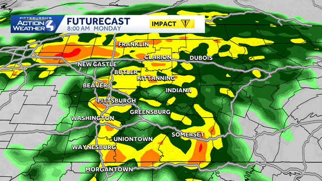
The area-wide rain threat holds off until late Sunday night. Monday is an Impact Day for periods of steady rain and possible storms. The heaviest rain will be falling during the morning commute with showers gradually decreasing once we get past lunch. A few thunderstorms may also be possible as the rain moves through the area.
Hearst OwnedHearst
Impact Day: Steady rain could be heavy at times for the Monday morning commute.
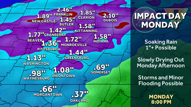
We are expecting about an inch of rain across western PA. Locally higher amounts from pockets of heavy rain and any embedded thunderstorms could show up south of Pittsburgh. Localized flooding may be an issue by late Monday.
Hearst OwnedHearst
Over an inch of rain could fall in 24 hours around western PA.
Seasonal start to summer
Tomorrow is also the Summer Solstice. Summer officially begins at 4:24 a.m. After Monday’s rain, we remain seasonal through next week with highs in the upper 70s to 80 degrees.
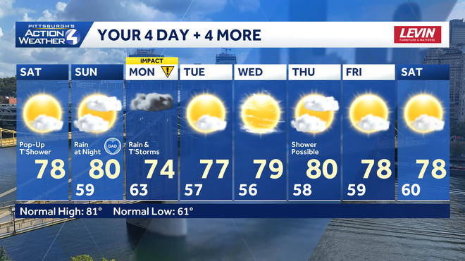
Hearst OwnedHearst
Monday is our best chance for rain over the next week.
TODAY: Partly cloudy, a tad breezy and seasonal. Pop-up shower or storm. High: 78°.
TONIGHT: Drying out, mainly clear and pleasant. Low: 59°.
SUNDAY: A bit warmer with increasing clouds. Rain arrives overnight. High: 80°, low: 63°.
MONDAY – Impact Day: Steady morning rain, lingering afternoon showers with embedded storms. High: 74°, low: 57°.
TUESDAY: Partly cloudy and pleasant. High: 77°, low: 56°.