
SHORT TERM FORECAST
TONIGHT: Becoming mainly clear. Low: 58
WEDNESDAY: Mostly sunny and pleasant. High: 82
WEDNESDAY NIGHT: Mostly clear and comfortable. Low: 59
FORECAST SUMMARY
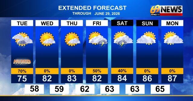
Monday’s rainy conditions lingered into our Tuesday afternoon, providing us with some much-needed rainfall. While we’ll have to wait to learn how much rain we received on Tuesday, Monday’s final total was 0.79″ — beneficial, but likely not enough to pull us out from the drought conditions the Lehigh Valley is under. With the passing of a cold front late this afternoon we should see the rain end, giving us a few hours of dry weather to close out our Tuesday. These dry conditions look to persist into Wednesday, our nicest day of the week, where we’ll see clearer skies with the return of the sun, and temperatures rise back to the near-mid 80s. Sadly, these conditions will not last long, as shower and thunderstorm activity looks to come back late Thursday evening. The beginning of the weekend looks to be wet, though we do get some clearing for Sunday which sets us up for some warmer and drier weather for the beginning of the work week.
DETAILED FORECAST
TUESDAY NIGHT AND WEDNESDAY
Skies will remain mostly cloudy Tuesday with showers lingering into the late afternoon hours. It will be a breezier day with some gusts around 25 mph. Skies become mainly clear later this evening and remain that way through the night. Temperatures will be in the upper 50s overnight, rising to the low 80s for Wednesday. Wednesday looks to be a mostly sunny day from start to finish. Wednesday night will see the last day of sub-60-degree overnight low for the rest of upcoming week as the fairly comfortable start to summer continues through the middle of the week.
THURSDAY AND FRIDAY
Later in the week, we’ll watch a cold front bring some scattered showers and thunderstorm chances Thursday night, with those chances lingering through the day on Friday as the front slowly makes its way through the area. Most of Thursday ends up dry with any storms not until late in the day, and Friday won’t be a washout either, although scattered shower and storm chances are possible anytime with probably more in the way of clouds as well. Highs both days remain seasonable in the mid-80s.
THIS WEEKEND
The first full weekend of summer, and last weekend of June, look to give us split conditions weather-wise. Both days look to be partly sunny, with more clouds around on Saturday with the chance for showers and thunderstorms lingering, and Sunday looking dry. Temperatures both days will be seasonably warm highs in the mid 80s each afternoon, and still comfy lows in the low 60s. There are some signs that some heat and humidity may try to build into the area to start July the following week.
TRACK THE WEATHER:
LINKS: HOUR BY HOUR | RADAR | TRAFFIC