
ALERT: Extreme heat warning issued ahead of dangerous stretch of triple-digit feels in south-central Pennsylvania
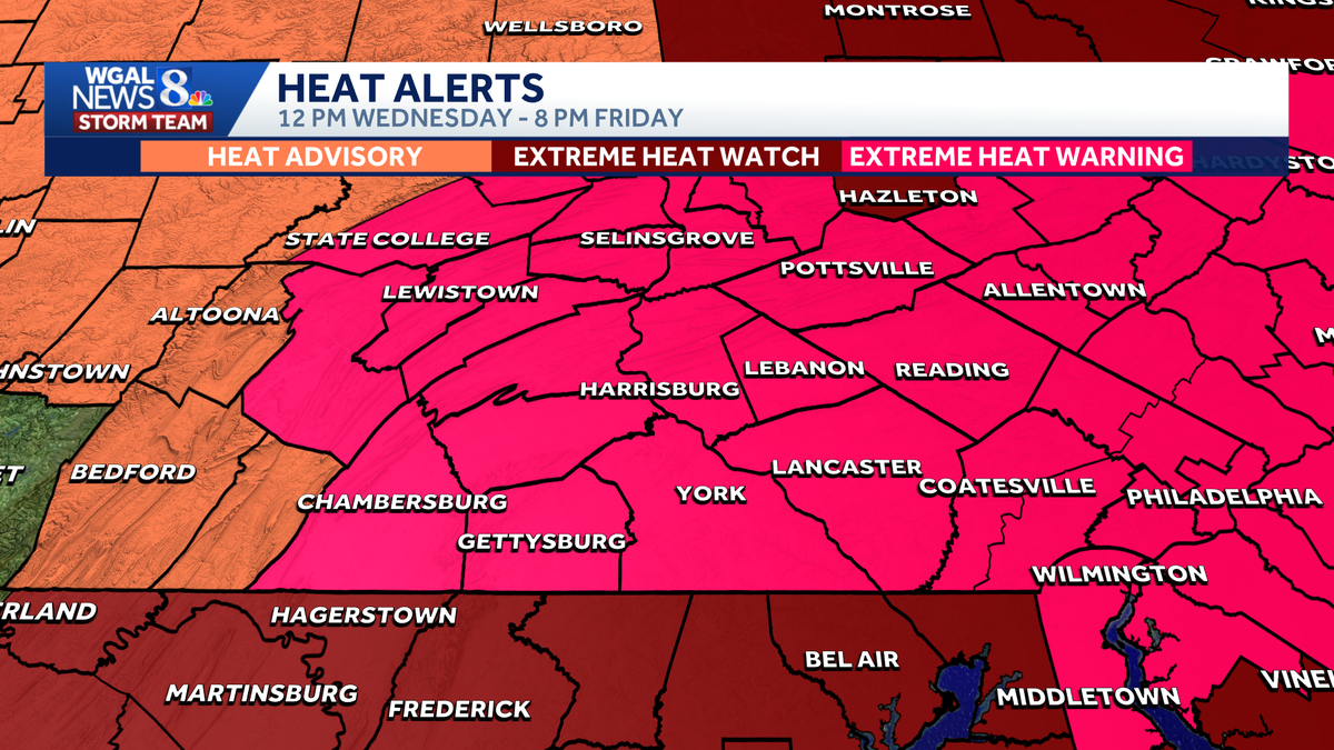
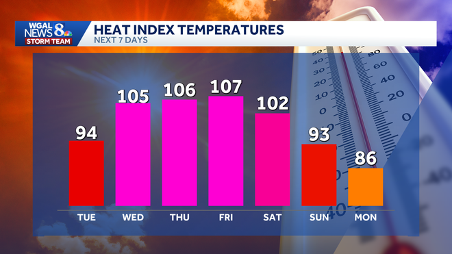
NOW THE WGAL NEWS EIGHT STORM TEAM FORECAST WITH CHIEF METEOROLOGIST CHRISTINE FERREIRA. GOOD MORNING. IT IS 523. OUR EXTREME HEAT WATCH HAS BEEN UPGRADED TO A WARNING. NOW YOU CAN SEE THAT MAGENTA COLOR ACROSS THE SUSQUEHANNA VALLEY FROM NOON TOMORROW UNTIL 8 P.M. FRIDAY. WE ARE UNDER THAT EXTREME HEAT WARNING. THEN A HEAT ADVISORY GOES INTO EFFECT ON SATURDAY. A LITTLE BIT OF A STEP DOWN, BUT FOR THE FOURTH, IT’S STILL GOING TO BE TOASTY WITH FEELS LIKE TEMPERATURES NEAR 100. SO HERE’S A LOOK AT OUR HEAT INDEX FORECAST OVER THE NEXT COUPLE OF DAYS. TODAY GETTING HOTTER. FEELING LIKE THE MID 90S OUT THERE. TOMORROW WE HAVE THE STEAMY HEAT, SULTRY HEAT ON THURSDAY AND SCORCHING HEAT ON FRIDAY. THOSE DAYS, DEW POINTS GO INTO THE 70S, SO THAT REALLY DOES AFFECT HOW IT FEELS, ESPECIALLY WHEN TEMPERATURES ARE CLOSE TO 100. NOW, A LOT OF FOLKS HAVE BEEN ASKING ABOUT THE 4TH OF JULY. I SEE HIGHS IN THE MID 90S. THEN WITH A HEAT INDEX 100 TO 104. SO STILL A OPPRESSIVE HEAT, BUT JUST NOT AS INTENSE AS THE NEXT FEW DAYS. HEAT ADVISORY IN EFFECT ON THE FOURTH. AND WE WILL ALSO HAVE SOME SCATTERED SHOWERS AND THUNDERSTORMS. SECOND HALF OF THE DAY WILL BE HIT OR MISS. VARIETY, BUT ISOLATED STORMS MAY PRODUCE SOME BRIEF HEAVY RAIN, AS WELL AS DAMAGING WIND GUSTS. WE WILL KEEP YOU POSTED AS DETAILS EVOLVE AND WE GET CLOSER TO SATURDAY, GETTING YOU THAT HOUR BY HOUR FORECAST. HERE’S OUR NEWS EIGHT STORM TEAM FORECAST. TODAY THOUGH WE HAVE SUNSHINE THIS MORNING. IT’S MUGGY OUT THERE. HOT AND HUMID THIS AFTERNOON WE GO FOR 92. AND THEN THIS EVENING A FEW CLOUDS, LIGHT WINDS, TEMPERATURES DROP TO THE 80S. TONIGHT. PARTLY CLOUDY, MUGGY. A LITTLE PATCHY FOG HERE AND THERE. 72 TO 76. NOT COOLING OFF VERY MUCH AT NIGHT. AND TOMORROW WE GO FOR THE SWELTERING HEAT. THE STEAMY SUNSHINE 96 TO 100 DEGREES. KEEPING IN MIND THE RECORD IS 100 FOR TOMORROW. RIGHT NOW IT’S 68 IN CARLISLE. SOUNDS A LOT COOLER, RIGHT? 66 IN LEBANON, 65 IN YORK. WE HAVE 64 IN SELINSGROVE IN LEWISTOWN, DEW POINTS JUST ABOUT MATCHED, SO THERE COULD BE A LITTLE PATCHY FOG HERE AND THERE, BUT I’M NOT SEEING IT AS WIDESPREAD AS WHAT WE SAW YESTERDAY. TODAY WE’RE IN THE HUMID ZONE, BUT WE REALLY CRANK THE HUMIDITY TOMORROW, THURSDAY AND FRIDAY. AND THAT’S WHAT LEADS TO OUR ALERT DAYS BECAUSE THE COMBO OF HIGH HEAT, HIGH HUMIDITY MAKES IT QUITE DANGEROUS. POLLEN LEVELS FOR GRASS, MODERATE AIR QUALITY IS MODERATE. TODAY. TIME OF JUST 15 TO 20 MINUTES. HERE’S THE STORM TEAM LIVE RADAR NETWORK. NOT MUCH TO POINT OUT BESIDES THIS BIG DOME OF HEAT, WHICH IS RIGHT OVER OHIO. NOTICE HOW THE CLOUDS, THE RAIN GO UP AND AROUND THAT DOME OF HEAT AND INTO THE SUSQUEHANNA VALLEY THIS MORNING. WE JUST HAVE A COUPLE OF CLOUDS OUT THERE, AND WE ALSO WILL SEE THE FOCUS OF THE RAIN STAYING JUST OFF TO OUR NORTHEAST OVER THE NEXT FEW DAYS. SO HERE’S THE PREDICTOR BARELY SHOWING A SPRINKLE THIS AFTERNOON ACROSS THE COMMONWEALTH. TOMORROW WE START THE DAY WITH SUNSHINE AND WE WILL SEE MAINLY SUNNY SKIES, HAZY SUNSHINE THROUGHOUT THE DAY. PREDICTOR ONCE THE POP A STRAY SHOWER, BUT I THINK THE CHANCE IS VERY SLIM. AS WE GET INTO THURSDAY, WE HAVE THAT DOME OF HEAT RIGHT ON TOP OF PENNSYLVANIA, SO THAT MEANS NO CHANCES FOR RAIN. IT LOOKS LIKE IT’S A DRY ONE FOR US. REALLY STEAMY HOT WEATHER RIGHT ON TOP OF US. AND THAT’S THE DAY WE COULD ACTUALLY HIT 100 FOR OUR AIR TEMPERATURE, HEAT INDEX TEMPERATURES NEXT FEW DAYS TODAY MID 90S. THEN WE SEE THAT REALLY INTENSE HEAT WITH THE HEAT AND HUMIDITY MAKING IT FEEL LIKE TRIPLE DIGIT HEAT. AT THE END OF THE WEEK, THE HEAT DOES BREAK. IT TAKES A WHILE, BUT IT’S GOING TO BE QUITE A HEAT WAVE FOR US HERE. AFTER WE HIT 91 YESTERDAY. SO 92 IS THE FORECAST TODAY, 98 WEDNESDAY TRIPLE DIGITS FOR THURSDAY, POSSIBLY FRIDAY AND THEN INTO NEXT WEEK. IT’S JUST LOOKING LIKE A SIZZLING HOT STR
ALERT: Extreme heat warning issued ahead of dangerous stretch of triple-digit feels in south-central Pennsylvania

Updated: 6:06 AM EDT Jun 30, 2026
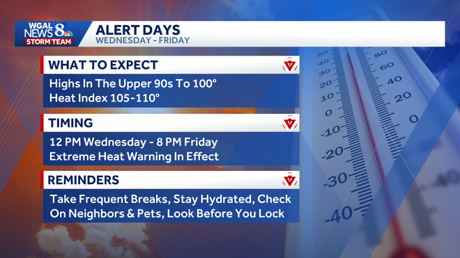
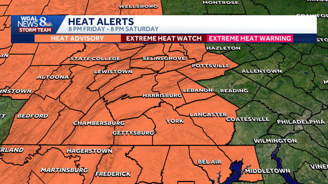
A prolonged stretch of dangerous heat is headed for south-central Pennsylvania, with near-record temperatures and triple-digit feels. What to knowAn extreme heat warning was issued from noon on Wednesday to 8 p.m. on Friday for the entire Susquehanna Valley. The WGAL News 8 Storm Team also declared Wednesday through Friday as Alert Days, meaning the forecast features the threat of extreme, severe, and possibly life-threatening weather. A heat advisory was also issued from 8 p.m. on Friday to 8 p.m. on Saturday, making it an Impact Day, meaning the weather will likely disrupt your normal daily schedule or routine. Near-record heatThe hottest stretch of the year is expected to arrive Wednesday and continue through Friday, making it feel like 105 to 110 degrees. Wednesday: Afternoon highs climb into the upper 90s, possibly nearing 100 degrees. The record is 100 degrees, set in 1931. Humidity will make conditions even more dangerous. Thursday: Temperatures will approach 100 degrees under mostly sunny skies. The record is 104 degrees, set in 1966. Overnight lows will only fall into the upper 70s. Friday: It remains dangerously hot, with highs near 100 degrees. The record is 107 degrees, set in 1966. While a few thunderstorms may develop, widespread rainfall is not expected. The last time Harrisburg hit 100 degrees was July 16, 2024. Fourth of July heat continues, slight relief SundaySaturday: Heat will persist into Independence Day, though conditions may ease slightly. Heat Advisory remains in effect until 8 p.m. Highs will reach the mid-to-upper 90s, with heat index values ranging from 100 to 104 degrees. Scattered afternoon and evening thunderstorms are possible, potentially bringing brief heavy rain and isolated damaging wind gusts. Sunday: The region may begin to see some improvement as the heat dome starts to retreat. Highs will be near 90 degrees, and humidity will linger. Scattered storms remain possible. Safety remindersStay hydrated and drink plenty of water. Limit outdoor activity during peak heat. Check on elderly neighbors, children and other vulnerable residents. Never leave children or pets in vehicles, even for short periods of time. Find a cooling station near you. Below: Hot weather tips to beat the heat. Did you capture a moment that you would like to share with News 8? Send us your photos or videos at https://www.wgal.com/upload.
A prolonged stretch of dangerous heat is headed for south-central Pennsylvania, with near-record temperatures and triple-digit feels.
What to know
An extreme heat warning was issued from noon on Wednesday to 8 p.m. on Friday for the entire Susquehanna Valley.
The WGAL News 8 Storm Team also declared Wednesday through Friday as Alert Days, meaning the forecast features the threat of extreme, severe, and possibly life-threatening weather.
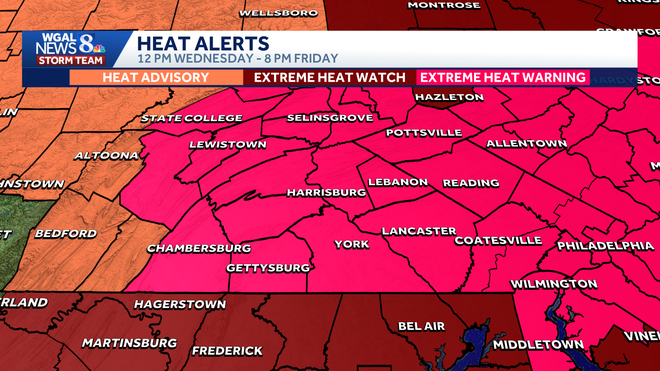
A heat advisory was also issued from 8 p.m. on Friday to 8 p.m. on Saturday, making it an Impact Day, meaning the weather will likely disrupt your normal daily schedule or routine.
Near-record heat
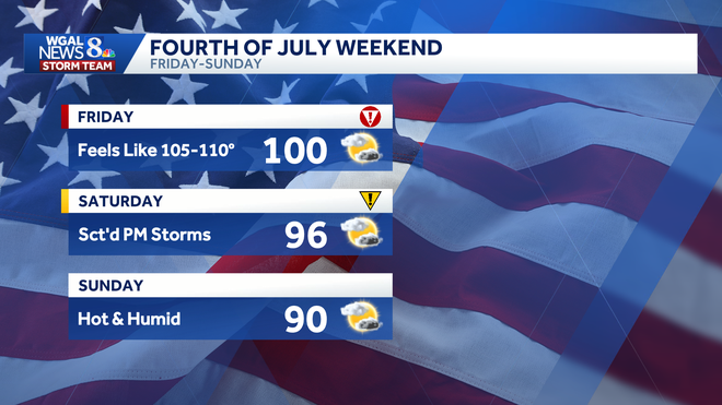
The hottest stretch of the year is expected to arrive Wednesday and continue through Friday, making it feel like 105 to 110 degrees.
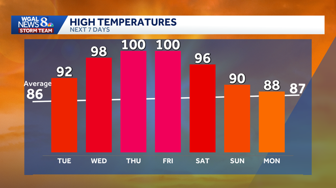
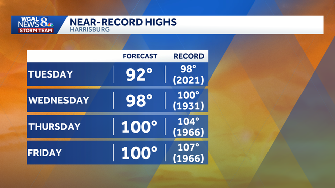
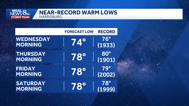
Wednesday: Afternoon highs climb into the upper 90s, possibly nearing 100 degrees. The record is 100 degrees, set in 1931. Humidity will make conditions even more dangerous. Thursday: Temperatures will approach 100 degrees under mostly sunny skies. The record is 104 degrees, set in 1966. Overnight lows will only fall into the upper 70s. Friday: It remains dangerously hot, with highs near 100 degrees. The record is 107 degrees, set in 1966. While a few thunderstorms may develop, widespread rainfall is not expected.
The last time Harrisburg hit 100 degrees was July 16, 2024.
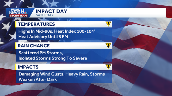
Fourth of July heat continues, slight relief SundaySaturday: Heat will persist into Independence Day, though conditions may ease slightly. Heat Advisory remains in effect until 8 p.m. Highs will reach the mid-to-upper 90s, with heat index values ranging from 100 to 104 degrees. Scattered afternoon and evening thunderstorms are possible, potentially bringing brief heavy rain and isolated damaging wind gusts.
Sunday: The region may begin to see some improvement as the heat dome starts to retreat. Highs will be near 90 degrees, and humidity will linger. Scattered storms remain possible.
Safety remindersStay hydrated and drink plenty of water. Limit outdoor activity during peak heat. Check on elderly neighbors, children and other vulnerable residents. Never leave children or pets in vehicles, even for short periods of time. Find a cooling station near you.
Below: Hot weather tips to beat the heat.
Did you capture a moment that you would like to share with News 8? Send us your photos or videos at https://www.wgal.com/upload.