Extreme heat continues across South-Central Pennsylvania
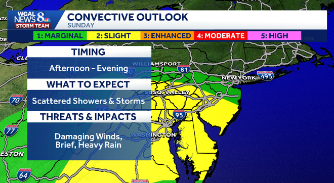
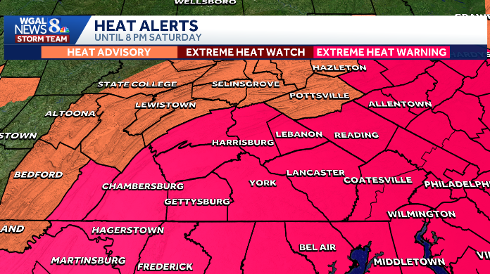
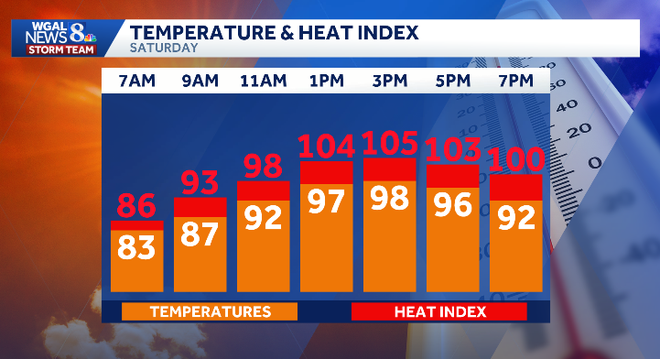
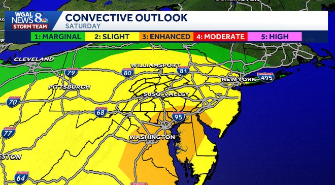
WGAL NEWS EIGHT STORM TEAM FORECAST WITH METEOROLOGIST MARYELLEN PANN. GOOD MORNING EVERYONE. DANGEROUS HEAT CONTINUES FOR ONE MORE DAY TODAY WITH THOSE TRIPLE HEAT INDICES EXPECTED BETWEEN 100 AND 110. THAT’S HOW HOT IT IS GOING TO FEEL OUTSIDE. AND THAT’S WHY WE HAVE IT AS AN ALERT DAY. NOW WE COULD SEE A FEW STORMS LATE AFTERNOON INTO THE EVENING WITH BECOMING MORE SCATTERED TOWARDS THE EVENING HOURS. AND THEN TOMORROW WE HAVE A BETTER CHANCE FOR STORMS. SO WE’VE MADE SUNDAY AN IMPACT DAY BOTH TODAY AND TOMORROW. ISOLATED STORMS TO SCATTERED STORMS MAY BE ON THE STRONG TO SEVERE SIDE WITH DAMAGING WINDS, THE MAIN THREAT. AND THEN FINALLY WE HEAD BACK TO SEASONAL AVERAGES AS WE GET BACK INTO THE WORKWEEK. NOW, THE NATIONAL WEATHER SERVICE DID EXPAND THE EXTREME HEAT WARNING TO INCLUDE FRANKLIN COUNTY, CUMBERLAND COUNTY AND PERRY COUNTY UNTIL 8:00 ALONG WITH THE REST OF THE AREA, AND THEN MIFFLIN AND JUNIATA COUNTY. YOU’RE UNDER A HEAT ADVISORY UNTIL 8 P.M. THIS EVENING. SO AS WE TAKE A LOOK AT THE TEMPERATURE IN THE HEAT, HEAT INDEX TEMPERATURES ARE ONCE AGAIN GOING TO CLIMB INTO THE UPPER 90S, BUT IT’S GOING TO FEEL MUCH HOTTER WITH THOSE WITH THE HUMIDITY FACTORED IN. SO THE TEMPERATURE AND THE HUMIDITY WILL RESULT IN TRIPLE DIGIT HEAT INDICES VALUES. IT’S STILL GOING TO BE QUITE HOT AROUND 7:00 8:00. NOW HERE IS THE CONVECTIVE OUTLOOK FROM THE STORM PREDICTION CENTER. AND YOU CAN SEE MOST OF THE AREA IN THE TWO, WHICH IS A SLIGHT RISK, A TWO ON A SCALE OF 1 TO 5, THERE IS AN AREA DOWN ACROSS I-95 INTO BALTIMORE, OVER TOWARDS DELAWARE, AND DOWN INTO THE SOUTHERN PORTION OF MARYLAND AND D.C. THAT’S IN AN ENHANCED RISK, WHICH IS A THREE ON A SCALE OF 1 TO 5, IT DOES CLIP SOUTHERN LANCASTER. AND THAT JUST MEANS THAT DAMAGING WIND GUSTS, THERE’S JUST A LITTLE BIT HIGHER THREAT FOR THOSE DAMAGING WINDS TO THE SOUTH AND SOUTHEAST. SO THE TIMING WOULD BE LATE AFTERNOON INTO THE EVENING. THEY SHOULD BE OUT OF HERE BY MIDNIGHT. UNFORTUNATELY, THERE COULD STILL BE A FEW STORMS AROUND AS FIREWORKS ARE GOING OFF ACROSS PARTS OF THE AREA. NOT EVERYBODY WILL SEE THEM, BUT THEY WILL BE THERE AGAIN WITH DAMAGING WIND GUSTS, BRIEF HEAVY RAIN OR HEAVY RAIN AS A POSSIBILITY. SO THE 4TH OF JULY PLANNER LOOKS LIKE THIS SULTRY SUNSHINE THIS MORNING. TEMPERATURES AT 88 DEGREES BY 9:00 98 IS WHERE WE’RE HEADED THIS AFTERNOON WITH THOSE ISOLATED STORMS IN THE AFTERNOON BECOMING MORE SCATTERED TOWARDS THE EVENING HOURS. AND THEN A FEW STORMS MAY STILL BE AROUND AS FIREWORKS ARE TAKING PLACE. TONIGHT, STORMS AND PARTLY CLOUDY. TEMPERATURES DROP INTO THE LOW TO MID 70S, LOW 70S. AND THEN TOMORROW, PARTLY SUNNY. A BETTER CHANCE FOR SCATTERED SHOWERS AND THUNDERSTORMS IN THE AFTERNOON AND EVENING. TEMPERATURES RIGHT AROUND 90 DEGREES. YOUR FEELS LIKE TEMPERATURES IN THE LOW TO MID 90S IN YOUR WEATHER AND HEALTH CHECK. GRASS POLLEN IS MODERATE. AIR QUALITY IS POOR, AND THE UV INDEX IS VERY HIGH TODAY WITH THE BURN TIME OF 15 MINUTES. AND IT’S GOING TO BE STARTING. WE’LL START TO SEE THAT UV INDEX DROPPING THE NEXT COUPLE OF DAYS WITH MORE CLOUD COVER. TEMPERATURES RIGHT NOW 80 DEGREES IN HARRISBURG. YESTERDAY WE HAD A LOW OF 81. THAT WAS A RECORD. TWO DAYS IN A ROW WOULD BE ANOTHER RECORD. WE’VE NEVER HAD TWO DAYS OF MORNING LOWS, AROUND 80 DEGREES. THOSE WOULD BE THE WARMEST. LOWS ON RECORD 76 IN CARLISLE AND IN LANCASTER. YOUR DEW POINTS ARE IN THE LOW 60S. I DO EXPECT THOSE NUMBERS TO CLIMB. IT’S QUIET RIGHT NOW, BUT I’M WATCHING THESE STORMS RIGHT HERE ACROSS NORTHEAST OHIO AND INTO THE GREAT LAKES. THAT CLUSTER OF STORMS MAY BE COMING IN OUR DIRECTION AS WE HEAD FURTHER INTO THE AFTERNOON AND THE EVENING HOURS. SO HERE’S A LOOK AT PREDICTOR. WE’RE DRY MOST OF THE DAY. AND THEN AS WE GET PAST 4:00, 5:00, WE SEE SOME OF THOSE STORMS DEVELOPING. THE BEST CHANCES TOWARDS THE EVENING HOURS. AND THEN ONCE WE GET TOWARDS 10:00 TO MIDNIGHT, WE SEE THOSE STORMS MOVING OUT OF HERE TOMORROW. THIS FRONTAL BOUNDARY IS STILL GOING TO BE NEARBY, ACTING AS A TRIGGER FOR SCATTERED SHOWERS AND STORMS IN THE AFTERNOON AND EVENING. AND AGAIN, SOME OF THEM COULD BE ON THE STRONG TO SEVERE SIDE. THIS FRONT’S NOT GOING ANYWHERE, SO WE’RE STILL GOING TO SEE THE CHANCE FOR SCATTERED SHOWERS AND STORMS ON MONDAY. AND AGAIN, WE’RE HIGHLIGHTED IN A SLIGHT RISK FOR TOMORROW WITH DAMAGING WINDS. THE POSSIBILITY AND SOME HEAVY RAIN BETWEEN THE AFTERNOON AND THE EVENING. QUICK LOOK AT YOUR TEN DAY FORECAST SHOWS WE ARE ONLY AT 80 DEGREES ON MONDAY, SO FINALLY SOME COOLER TEMPERATURES. LOW 80S ON TUESDAY. STILL STORMS AROUND POSSIBLY. AND THEN WE START TO SEE THAT STOR
The dangerous heat will linger through Saturday evening in South-Central Pennsylvania, with a few rounds of storms possible today and Sunday before the worst of the heat eases.The WGAL News 8 Storm Team has designated Saturday as an Alert Day and Sunday as an Impact Day. Heat alerts in effectExtreme Heat Warning extended until 8 p.m. Saturday for:LancasterYorkAdamsDauphinFranklinCumberlandPerryLebanon countiesHeat Advisory begins 8 p.m. Saturday for:MifflinJuniata countiesToday’s forecastHighs will reach the upper 90sIt will feel like 100 to 110 degreesA few afternoon storms are possible, with more storms this eveningSome storms could bring:Brief heavy rainDamaging wind gustsStorms may still be around for fireworks at 10 p.m.Temperatures then should be around 86 degreesSunday outlookImpact Day SundayScattered storms are possible as the heat dome moves outSome storms could still produce:Damaging wind gustsHeavy rainHighs will reach about 90 degreesIt will remain humid, but the most intense heat will easeFeels-like temperatures should be 92 to 96 degrees
The dangerous heat will linger through Saturday evening in South-Central Pennsylvania, with a few rounds of storms possible today and Sunday before the worst of the heat eases.
The WGAL News 8 Storm Team has designated Saturday as an Alert Day and Sunday as an Impact Day.
Heat alerts in effectExtreme Heat Warning extended until 8 p.m. Saturday for:LancasterYorkAdamsDauphinFranklinCumberlandPerryLebanon countiesHeat Advisory begins 8 p.m. Saturday for:
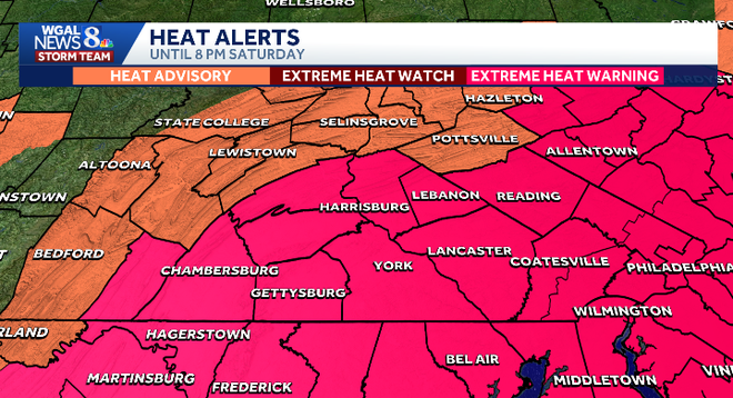
Today’s forecastHighs will reach the upper 90sIt will feel like 100 to 110 degreesA few afternoon storms are possible, with more storms this eveningSome storms could bring:Brief heavy rainDamaging wind gustsStorms may still be around for fireworks at 10 p.m.Temperatures then should be around 86 degrees
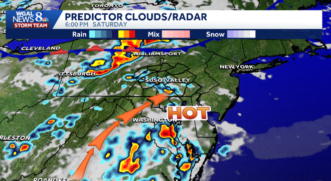
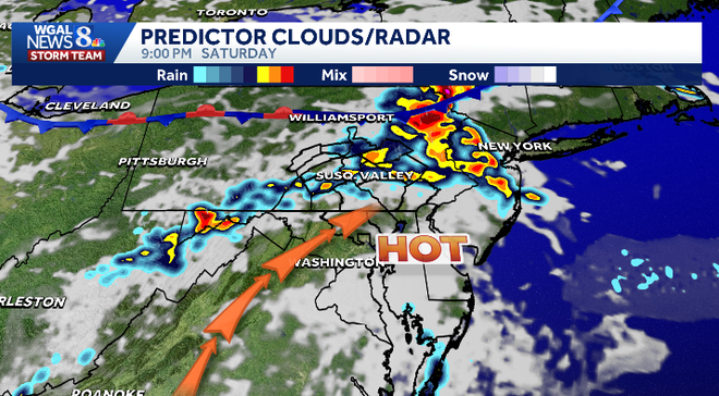
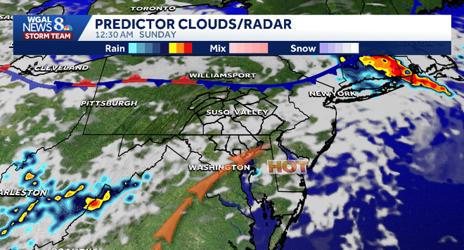
Sunday outlookImpact Day SundayScattered storms are possible as the heat dome moves outSome storms could still produce:Damaging wind gustsHeavy rainHighs will reach about 90 degreesIt will remain humid, but the most intense heat will easeFeels-like temperatures should be 92 to 96 degrees