
Our attention turns away from the sweltering heat and humidity, and toward better rain and storm chances. Today’s Impact Day is for more heavy rain and gusty winds this afternoon and evening. WATCH THE LATEST WEATHERCAST IN THE PLAYFINDER ABOVE Flash Flood Warning Multiple counties are under a Flash Flood Warning until 7:15 p.m. Counties under the warning include Allegheny, Washington, Westmoreland, Butler, and Beaver. Some locations that will experience flash flooding include… Pittsburgh, Penn Hills, Ross Township, McCandless Township, Monroeville, Moon Township, Franklin Park, Aliquippa, Shaler Township, Plum, North Side Pittsburgh, Baldwin, Murrysville and Hampton Township.Armstrong and Clairon counties are also a warning until 7:45 p.m. Turn around, don’t drown when encountering flooded roads, the National Weather Service says. Most flood deaths occur in vehicles. Be aware of your surroundings and do not drive on flooded roads. More: Read the weather alert for your countyInteractive radar: Track storms in your areaLearn how to enable automatic weather alerts on the WTAE app Flood Watch in effect A Flood Watch has been issued for parts of Western Pennsylvania on Sunday. The National Weather Service said the watch will go into effect at 3 p.m. and will last until 10 p.m. The following counties are under the watch: Mercer, Lawrence, Butler, Beaver, Allegheny, Armstrong, Washington, Westmoreland, Fayette, and Indiana Cities include: Lower Burrell, Greensburg, Murrysville, Weirton, Indiana, Canonsburg, Ellwood City, Hermitage, Ohiopyle, Monaca, New Kensington, Sharon, Salem, Donegal, Ford City, Ligonier, Uniontown, Wellsburg, Monessen, Ambridge, Champion, East Liverpool, Wheeling, Kittanning, Columbiana, Beaver Falls, New Castle, Aliquippa, Follansbee, Butler, Armagh, Grove City, Pittsburgh Metro Area, Washington, and LatrobeThe National Weather Service said excessive runoff may result in the flooding of creeks, streams, and other low-lying and flood-prone locations. Not every location in the flash flood watch will see rain; however, downpours are likely with any shower or storm. Impact Day: Scattered heavy rain, a stormToday’s Impact Day is for scattered heavy rain and storm chances for anytime after noon.Rain is possible area-wide but any storms won’t be as intense as the previous two days. The rushes of heavy rain could also bring gusty winds. The main concern is for localized flash flooding, especially in already saturated spots.Showers linger through Tuesday morning This slow-moving system will keep off and on showers around to start the new week. Most of Monday’s activity will be during the afternoon and spotty in coverage. Tuesday morning will be feature a few more showers before we dry out.Your rain gear will only have a brief rest. More summer showers and storms are possible by late week.TODAY – Impact Day. Scattered afternoon downpours and isolated storms. Not as hot, still muggy. High: 84°, TONIGHT: Drying out with areas of fog, low: 70°.MONDAY: Mostly cloudy with scattered afternoon rain. High: 81°, low: 68°.TUESDAY: Morning showers then mostly cloudy. High: 80°, low: 66°.
Our attention turns away from the sweltering heat and humidity, and toward better rain and storm chances. Today’s Impact Day is for more heavy rain and gusty winds this afternoon and evening.
WATCH THE LATEST WEATHERCAST IN THE PLAYFINDER ABOVE
Severe Thunderstorm Warning
A Severe Thunderstorm Warning has been issued for parts of Western Pennsylvania on Sunday.
The alert is in place for the following counties until 5 p.m.: Allegheny, Westmoreland, Armstrong, Butler, and Clairon.
The following areas are impacted: Vandergrift, Kittanning, Apollo, Rimersburg, Harrison Township, Natrona Heights, Ford City, Leechburg, Sarver, Freeport, New Bethlehem, West Kittanning, North Apollo, West Leechburg, Orchard Hills, East Brady, Rural Valley and Parker.
Officials with the National Weather Service said wind gusts could go up to 60 miles per hour, with heavy rainfall likely.
Flash Flood Warning
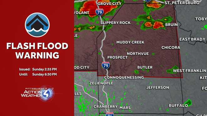
Multiple counties are under a Flash Flood Warning until 7:15 p.m.
Counties under the warning include Allegheny, Washington, Westmoreland, Butler, and Beaver.
Some locations that will experience flash flooding include… Pittsburgh, Penn Hills, Ross Township, McCandless Township, Monroeville, Moon Township, Franklin Park, Aliquippa, Shaler Township, Plum, North Side Pittsburgh, Baldwin, Murrysville and Hampton Township.
Armstrong and Clairon counties are also a warning until 7:45 p.m.
Turn around, don’t drown when encountering flooded roads, the National Weather Service says. Most flood deaths occur in vehicles. Be aware of your surroundings and do not drive on flooded roads.
Flood Watch in effect
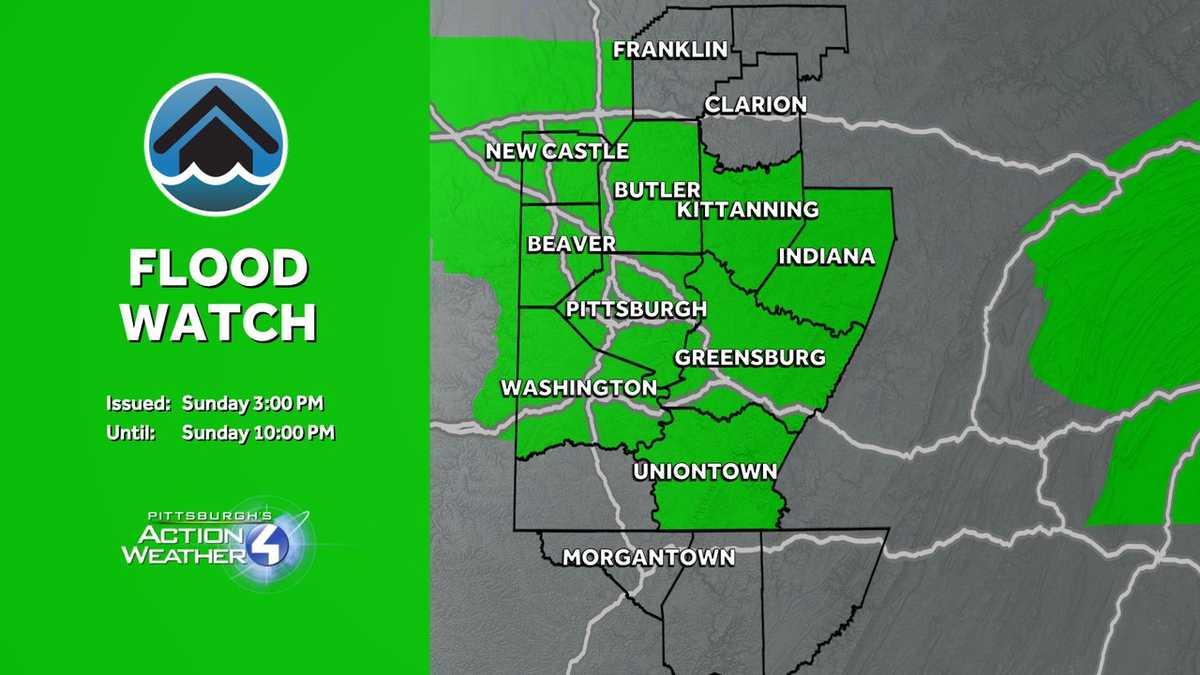
A Flood Watch has been issued for parts of Western Pennsylvania on Sunday.
The National Weather Service said the watch will go into effect at 3 p.m. and will last until 10 p.m.
The following counties are under the watch: Mercer, Lawrence, Butler, Beaver, Allegheny, Armstrong, Washington, Westmoreland, Fayette, and Indiana
Cities include: Lower Burrell, Greensburg, Murrysville, Weirton, Indiana, Canonsburg, Ellwood City, Hermitage, Ohiopyle, Monaca, New Kensington, Sharon, Salem, Donegal, Ford City, Ligonier, Uniontown, Wellsburg, Monessen, Ambridge, Champion, East Liverpool, Wheeling, Kittanning, Columbiana, Beaver Falls, New Castle, Aliquippa, Follansbee, Butler, Armagh, Grove City, Pittsburgh Metro Area, Washington, and Latrobe
The National Weather Service said excessive runoff may result in the flooding of creeks, streams, and other low-lying and flood-prone locations. Not every location in the flash flood watch will see rain; however, downpours are likely with any shower or storm.
Impact Day: Scattered heavy rain, a storm
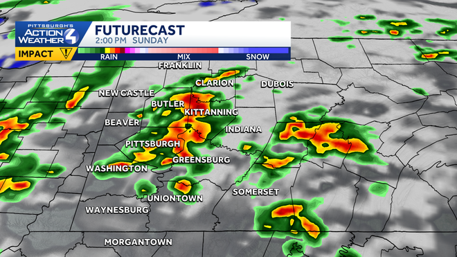
Today’s Impact Day is for scattered heavy rain and storm chances for anytime after noon.
Hearst OwnedHearst
The peak time for heavy rain is between 2 p.m. and 6 p.m.
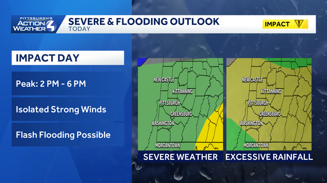
Rain is possible area-wide but any storms won’t be as intense as the previous two days. The rushes of heavy rain could also bring gusty winds. The main concern is for localized flash flooding, especially in already saturated spots.
Hearst OwnedHearst
A flash flooding risk is favored over severe weather for today’s Impact Day.
Showers linger through Tuesday morning
This slow-moving system will keep off and on showers around to start the new week. Most of Monday’s activity will be during the afternoon and spotty in coverage. Tuesday morning will be feature a few more showers before we dry out.
Your rain gear will only have a brief rest. More summer showers and storms are possible by late week.

Hearst OwnedHearst
Temperatures trend more seasonal with slightly lower humidity levels for the first full week of July.
TODAY – Impact Day. Scattered afternoon downpours and isolated storms. Not as hot, still muggy. High: 84°,
TONIGHT: Drying out with areas of fog, low: 70°.
MONDAY: Mostly cloudy with scattered afternoon rain. High: 81°, low: 68°.
TUESDAY: Morning showers then mostly cloudy. High: 80°, low: 66°.