
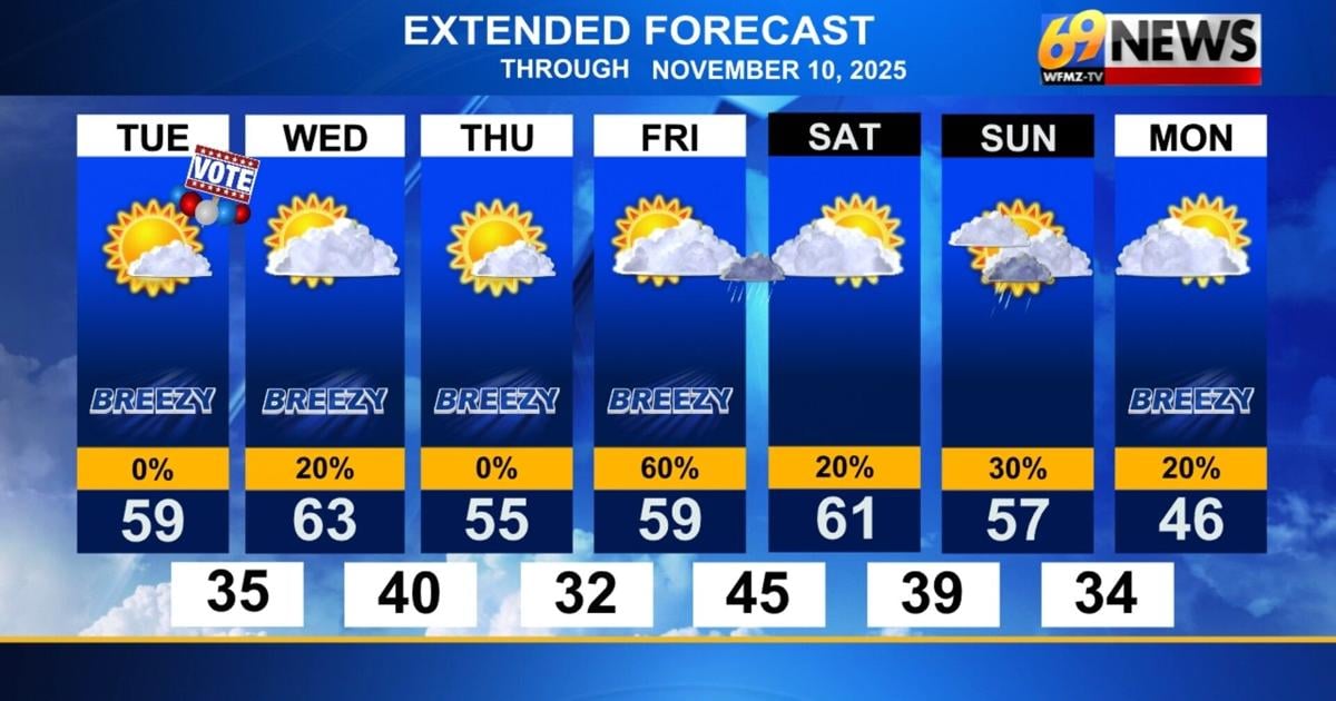
SHORT TERM FORECAST
TONIGHT: Becoming mostly clear and breezy overnight. Low: 41
TUESDAY: Mostly sunny, breezy, and seasonable. Nice weather for election day! High: 59
TUESDAY NIGHT: Mostly clear with lighter winds. Low: 35…..
FORECAST SUMMARY
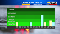
November is underway, and it’s been a fairly dry and pleasant start to the month over the last three days. Our average high temperature in early November is in the upper 50s to right around 60°, and sure enough, that’s where we’ve been since Saturday, with a mix of clouds and sunshine each day. Looking ahead to the rest of the week ahead, most days are seasonably mild not far from and in some cases a little above the 60-degree mark. Thursday sticks out as a little cooler compared to other days, with highs in the mid 50s, still not bad at all for this time of year. Perhaps the biggest temperature headline awaits for early next week, with the first arctic blast of the season possible by Monday, when highs may struggle to make the mid 40s with even colder wind chills. While there are no big storms in sight, there are a series of cold fronts that will slide through over the next seven days, each bringing the chance for at least a few showers. The first front Wednesday night will only bring the chance of a few scattered showers, mostly in the Poconos. The second cold front Friday night is the best chance for widespread showers for most of the area. The final front Sunday night will bring the shot of cold air early next week, with a few rain showers out ahead of it, and perhaps even some Pocono flurries behind it on Monday.

DETAILED FORECAST
TONIGHT
Skies will become mostly clear this evening and remain that way overnight, as it also turns breezy behind a cold front. There’s no chilly air behind this front, just some wind, so overnight lows won’t be too cool and remain in the low 40s. Winds will shift from the west and increase to 10-15mph with gusts to 20-25mph overnight.
ELECTION DAY TUESDAY
Weather looks nice for voters in Pennsylvania and New Jersey on Election Day, with plenty of sunshine and seasonably cool/mild highs in the upper 50s, just a few degrees cooler than recent days. A brisk west to northwest breeze around 10-20mph with gusts to 30mph will make it feel a bit cooler, with that breeze a persistent one throughout the day, before diminishing towards evening and overnight.
WEDNESDAY
Winds will shift from the southwest on Wednesday ahead of our next cold front for Wednesday night, which will allow milder highs around 60-65° for Wednesday afternoon. Winds will be light in the morning, but more noticeable in the afternoon, around 10-15mph with gusts to 20-25mph. As the cold front slides through Wednesday night, a few light and scattered rain showers are possible, but mostly confined to areas north of the Lehigh Valley through the Poconos and far North Jersey.
THURSDAY AND FRIDAY
Winds shift back from the west and northwest for Thursday behind our next cold front, and temps will trend a little cooler as a result. Skies should be partly to mostly sunny on Thursday, with slightly cooler highs in the mid 50s and a cooler northwest breeze (15mph, gusts to 30mph). Breezes will then diminish Thursday night, but pick up again Friday as the next in our series of cold fronts approaches. On Friday, it’s that milder southwest breeze back for an encore, so likewise highs should approach 60-degrees once again as sunshine mixes with increasing afternoon clouds. The best chance of rain in the forecast for the entire area arrives with that front Friday night, with at least a few tenths of an inch of rain expected, mostly overnight Friday night.
THIS WEEKEND
We should be “in-between” fronts for Saturday and even most of Sunday, and remain relatively mild with highs around 60-degrees on Saturday, and seasonable in the mid to upper 50s on Sunday. Most of Saturday looks dry, but a few rain showers are possible by Sunday as our next front and low pressure develops. This is the front with a notable shot of cold air behind it, which we will feel early next week.
EARLY NEXT WEEK
Monday looks to be the coldest day (and night) of the fall so far, with gusty winds and highs perhaps struggling to do much better than the mid 40s, a good 10-15 degrees colder than average for early November. There could even be some sprinkles or even Pocono flurries around on Monday, with lake effect and mountain snows possible to our north over the Great Lakes and New England. Nighttime lows may drop into the 20s area-wide Monday night.
TRACK THE WEATHER:
LINKS: HOUR BY HOUR | RADAR | TRAFFIC