
Western PA: Rain and storms Thursday and Friday
Localized flooding is the primary concern from heavy rain heading into the weekend.
CONGRESS ALLOWED ENHANCED SUBSIDIES TO EXPIRE FURTHER NORTH. YOU LIVE THIS MORNING. THE DRYER YOU ARE NOW, IF YOU LIVE ALONG INTERSTATE 70, EVEN ON SOUTH INTO WASHINGTON, GREENE, EVEN WESTMORELAND AND FAYETTE COUNTY, SOME SHOWERS PASSING THROUGH. THE NICE THING IS, THOUGH, THOSE POCKETS OF HEAVY RAIN ARE REALLY STARTING TO FIZZLE OUT, THAT WE’RE REALLY IMPACTING SOUTHERN PORTIONS OF FAYETTE COUNTY. BUT OVERALL, ALONG INTERSTATE 70TH MAY NOTICE A WET ROADWAY THIS MORNING. THE SUN IS UP. YOU TRYING TO PEEK THROUGH SOME OF THOSE CLOUDS, BUT OVERALL WE GOT MORE CLOUD COVER THE FURTHER SOUTH YOU LIVE AS THAT RAIN IS MOVING THROUGH, PLUS SOME LOWER VISIBILITY DOWN ABOUT FOUR MILES THERE INTO FAYETTE COUNTY. A ZERO MILE VISIBILITY IN PORTIONS OF INDIANA DOWN TO 4 TO 5 MILES INTO CLARION. EVEN ARMSTRONG. AND THIS IS EXTENDING INTO NORTHERN PARTS OF LAWRENCE COUNTY. TEMPERATURES AREN’T BAD. HUMIDITY IS STILL UP 68. WAKING UP IN PITTSBURGH, 72 RIGHT NOW IN GREENSBURG, 65. KITTANNING 63. CLARION AND FRANKLIN AND WAYNESBURG WAKING UP AT 68 THIS MORNING. WE’LL CLIMB INTO THE MID 80S TODAY. STILL GOING TO FEEL LIKE NEAR 90 WHEN YOU FACTOR IN THAT HUMIDITY, WE’RE EXTENDING INTO OUR IMPACT DAY ON FRIDAY. MORE WIDESPREAD RAIN WITH SOME POCKETS OF HEAVY RAINFALL. SO KEEP IN MIND WE’RE SEEING SOME RAIN SHOWERS ALREADY SOUTH OF THE CITY. THEN YOU’RE GOING TO GET HIT HARD FRIDAY WITH SOME POCKETS OF HEAVY RAINFALL. AND THAT’S WHEN THE FLASH FLOODING POTENTIAL COULD JUMP UP. SO AGAIN IT IS AN IMPACT DAY AS WE HEAD INTO TOMORROW. THESE RAIN SHOWERS THIS MORNING ARE GOING TO FIZZLE OUT. THEN AS WE GET AROUND 1:00. SO 1235 FIRST PITCH, YOU CAN SEE SOME POCKETS OF HEAVY RAIN PUSHING NEAR THE CITY OF WASHINGTON. EVEN CANONSBURG CLIPPING SOUTH AND EAST OF ALLEGHENY COUNTY ALONG THE PARKWAY EAST. JUST WILL IT NUDGE A LITTLE FURTHER NORTH TO GET INTO THE CITY? AND EVEN IF WE HEAR A FEW RUMBLES OF THUNDER, THEY WILL HAVE A RAIN DELAY. SO WE’LL BE WATCHING THAT VERY, VERY CLOSELY BY 2:00. THAT’S GOING TO EDGE INTO WESTMORELAND. SOME POCKETS OF HEAVY RAIN WILL BE RIDING ALONG INTERSTATE 70, JUST A LITTLE SOUTH OF GREENSBURG. BY THE TIME WE GET INTO THE EVENING COMMUTE, THOUGH, THIS ALL CALMS DOWN. YOU CAN SEE A LITTLE BIT OF SUNSHINE, A FEW PASSING SHOWERS ON THE OVERNIGHT, BUT A DRY MORNING COMMUTE ON FRIDAY AFTER 9:00, 10:00 IN THE MORNING, WE’LL START TO SEE THE ONSET OF THIS RAIN. THIS HAS BEEN CONSISTENT OVER THE PAST COUPLE OF DAYS. THE HEAVIEST OF RAIN IS GOING TO STAY SOUTH OF THE CITY OF PITTSBURGH. NOT SAYING WE CAN’T HAVE A STORM TRYING TO DEVELOP NORTH, BUT REALLY WASHINGTON AND GREENE AND PORTIONS OF FAYETTE COUNTY ARE THE COUNTIES WE’RE REALLY GOING TO BE WATCHING THAT HAVE BEEN HIT HARD THE PAST FEW DAYS NOW DOES MOVE OUT QUICKLY. BY SIX, 7:00, THINGS QUIET DOWN. HEADING INTO SATURDAY, YOU WAKE UP TO SOME MORNING FOG. A POP UP SHOWER CAN’T BE RULED OUT BETWEEN 2 AND 5, BUT MOST OF US ARE GOING TO STAY DRY SATURDAY AND ALL OF US STAYING DRY AS WE HEAD INTO SUNDAY. AND EVEN BETTER, ON SUNDAY, THE HUMIDITY DROPS. IT’S GOING TO BE MORE COMFORTABLE TO BE OUTSIDE SHORT LIVED. THOSE TEMPERATURES CLIMB BACK INTO T
Western PA: Rain and storms Thursday and Friday
Localized flooding is the primary concern from heavy rain heading into the weekend.

Updated: 11:36 AM EDT Jul 9, 2026
Humidity levels remain elevated and continues to plague us. Humidity will gradually drop over the weekend, after we see a few days of rain and storm chances. The wettest day this week will be Friday.Flood Watch TodayWe can’t rule out isolated showers and storms today, especially through the early afternoon. Showers start to wrap up during the evening commute with a stray shower or two into the overnight. With rain having fallen this morning south of Pittsburgh, a Flood Watch is up through 10 p.m. for Fayette, Greene, Monongalia, and Preston Counties.Impact Day – FridayWe likely start Friday generally dry before rain showers and thunderstorms begin to develop. Friday will see rain showers and thunderstorms developing into the afternoon and early evening. Even though some storms are possible, severe weather looks unlikely as we move through the day. Storms though will produce heavy rainfall and some gusty winds. Rain should come to an end as we get to sunset. By the time rain is done late on Friday, some locations could pick up over an inch of rain, leading to localized flooding concerns late Friday.Weekend Dries Out, Warming Up Next WeekShower chances may be possible this weekend, but any rain will be battling a ridge of high pressure setting up again across the area. Saturday is the best chance to see some rain, and that may be confined to mainly south of Interstate 70. Highs will warm into the start of next week with increasing sunshine. We will see 90° again by midweek.TODAY: Mostly cloudy with afternoon showers and storms. High: 85°.TONIGHT: Isolated showers, mostly cloudy. Low 69°.FRIDAY – Impact Day: Mostly cloudy with showers and storms. High: 83°, low: 68°.SATURDAY: Mostly cloudy with a few PM showers. High: 82°, low: 62°.SUNDAY: Mostly to partly cloudy. High: 83°, low: 64°.
PITTSBURGH —
Humidity levels remain elevated and continues to plague us. Humidity will gradually drop over the weekend, after we see a few days of rain and storm chances. The wettest day this week will be Friday.
Flood Watch Today
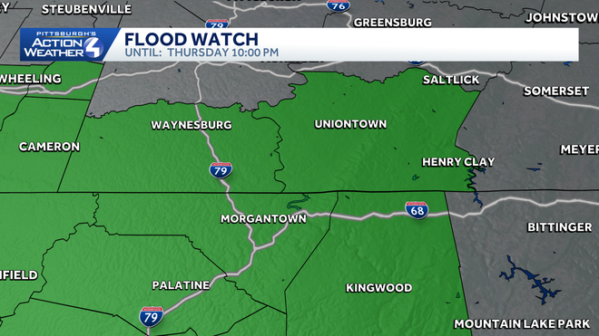
We can’t rule out isolated showers and storms today, especially through the early afternoon. Showers start to wrap up during the evening commute with a stray shower or two into the overnight. With rain having fallen this morning south of Pittsburgh, a Flood Watch is up through 10 p.m. for Fayette, Greene, Monongalia, and Preston Counties.
Hearst Owned
Flood Watch through 10 p.m. Thursday for Fayette, Greene, Monongalia, and Preston Counties.
Impact Day – Friday
We likely start Friday generally dry before rain showers and thunderstorms begin to develop.
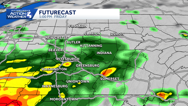
Friday will see rain showers and thunderstorms developing into the afternoon and early evening. Even though some storms are possible, severe weather looks unlikely as we move through the day. Storms though will produce heavy rainfall and some gusty winds. Rain should come to an end as we get to sunset. By the time rain is done late on Friday, some locations could pick up over an inch of rain, leading to localized flooding concerns late Friday.
Hearst Owned
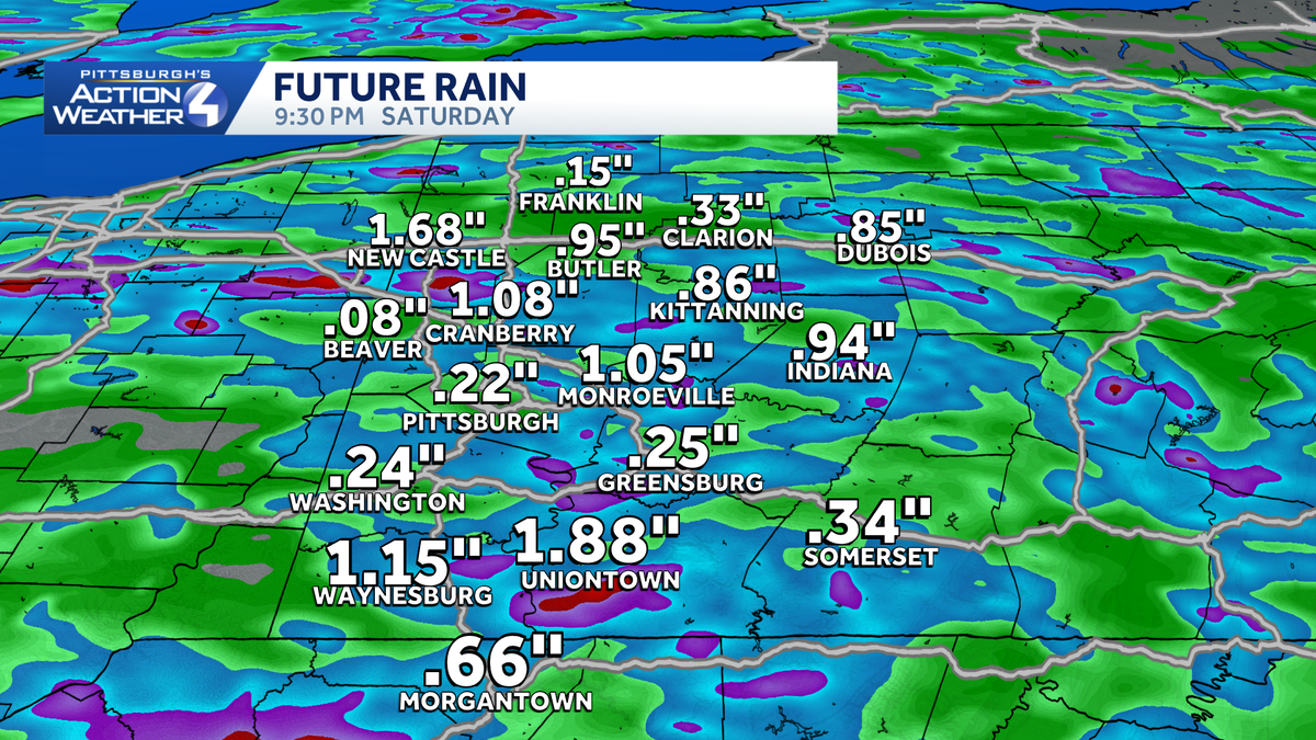
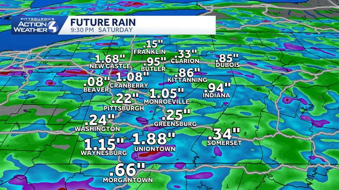
Some locations could pick up over an inch of rain on Friday, leading to localized flooding issues.
Weekend Dries Out, Warming Up Next Week
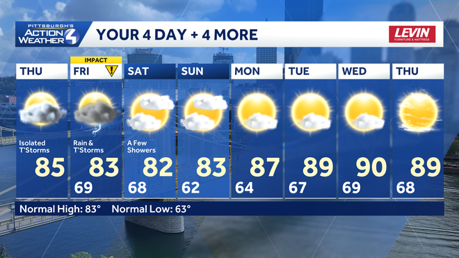
Shower chances may be possible this weekend, but any rain will be battling a ridge of high pressure setting up again across the area. Saturday is the best chance to see some rain, and that may be confined to mainly south of Interstate 70. Highs will warm into the start of next week with increasing sunshine. We will see 90° again by midweek.
Hearst Owned
Rain chances to end the week then warm again heading through next week.
TODAY: Mostly cloudy with afternoon showers and storms. High: 85°.
TONIGHT: Isolated showers, mostly cloudy. Low 69°.
FRIDAY – Impact Day: Mostly cloudy with showers and storms. High: 83°, low: 68°.
SATURDAY: Mostly cloudy with a few PM showers. High: 82°, low: 62°.
SUNDAY: Mostly to partly cloudy. High: 83°, low: 64°.