
A stretch of intense summer heat is expected to build across central Pennsylvania this week, with the hottest conditions arriving Tuesday and Wednesday. High temperatures will climb into the 90s from Tuesday through Friday, with the heat index nearing 100 degrees. The WGAL News 8 Storm team has declared Tuesday and Wednesday as Impact Days, meaning the weather will likely disrupt your normal daily schedule or routine. Heat advisoryThe National Weather Service has issued a heat advisory from 11 a.m. to 8 p.m. Tuesday for the northern part of the Susquehanna Valley, including: DauphinJuniata Lebanon MifflinPerry The affected areas will see highs in the mid-90s combined with dew points in the upper 60s, making it feel close to 100 degrees. Other parts of the region may fall just short of advisory criteria Tuesday, but heat index values in southern counties could still range from 98 to 100 degrees. Wednesday could be the peak of the heatWednesday is expected to be the hottest and most humid day of the stretch.Afternoon highs should reach 98 degrees.Tropical humidity will push dew points into the low 70s.Feels-like temperatures are expected to range from 100 to 104 degrees.NEAR-RECORD HEAT: In Harrisburg, the forecast high of 98 degrees is close to the daily record of 99, set in 2024. Highs for the weekTemperatures are expected to run above the seasonal average of 87 degrees for much of the week: Monday: 88Tuesday: 96Wednesday: 98Thursday: 94Friday: 90Saturday: 88Sunday: 86Warm nights offer little reliefOvernight lows will provide limited relief, especially by midweek. In Harrisburg, forecast morning lows are: Tuesday morning: 68Wednesday morning: 74Thursday morning: 74Friday morning: 74While those readings remain below daily warm-low records, they will still add to the discomfort. Heat eases later in the weekThe heat is expected to ease somewhat by Thursday and Friday, though conditions will remain hot and humid. Highs should reach about 94 on Thursday and 90 on Friday, with humidity beginning to drop by the end of the week. A slight chance of thunderstorms is also in the forecast for Friday. Safety precautionsResidents are urged to take precautions during the heat wave, including:Drink plenty of waterTake frequent breaks if working outdoorsWear light-colored, loose-fitting clothingLimit strenuous activity during the afternoonCheck on older adults, children and petsDid you capture a moment that you would like to share with News 8? Send us your photos or videos at https://www.wgal.com/upload.
A stretch of intense summer heat is expected to build across central Pennsylvania this week, with the hottest conditions arriving Tuesday and Wednesday.
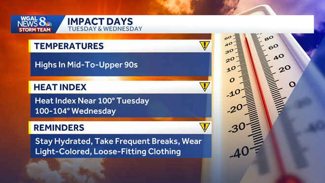
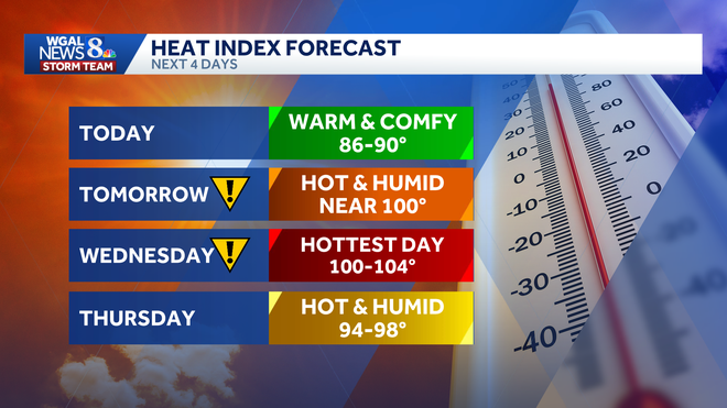
High temperatures will climb into the 90s from Tuesday through Friday, with the heat index nearing 100 degrees.
The WGAL News 8 Storm team has declared Tuesday and Wednesday as Impact Days, meaning the weather will likely disrupt your normal daily schedule or routine.
Heat advisory
The National Weather Service has issued a heat advisory from 11 a.m. to 8 p.m. Tuesday for the northern part of the Susquehanna Valley, including:
DauphinJuniata Lebanon MifflinPerry
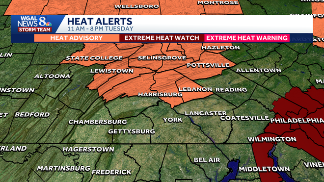
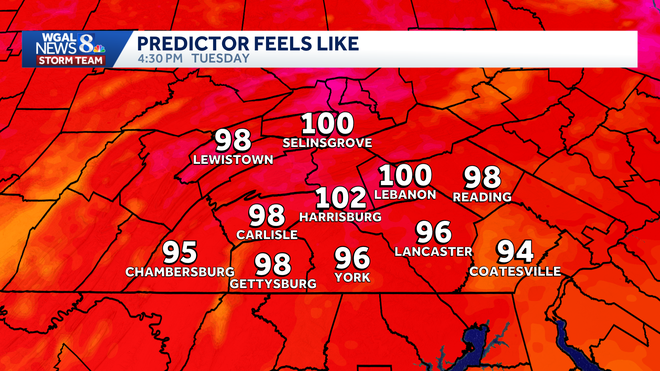
The affected areas will see highs in the mid-90s combined with dew points in the upper 60s, making it feel close to 100 degrees.
Other parts of the region may fall just short of advisory criteria Tuesday, but heat index values in southern counties could still range from 98 to 100 degrees.
Wednesday could be the peak of the heat
Wednesday is expected to be the hottest and most humid day of the stretch.
Afternoon highs should reach 98 degrees.Tropical humidity will push dew points into the low 70s.Feels-like temperatures are expected to range from 100 to 104 degrees.
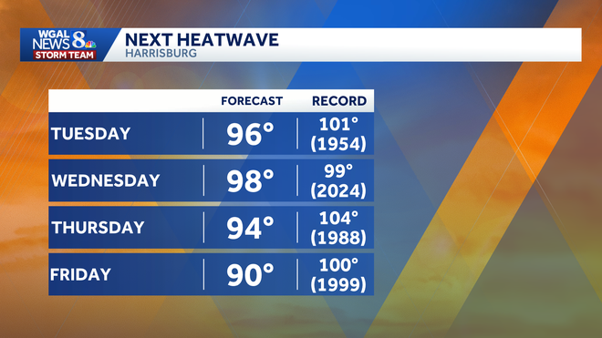
NEAR-RECORD HEAT: In Harrisburg, the forecast high of 98 degrees is close to the daily record of 99, set in 2024.
Highs for the week
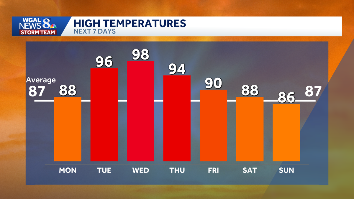
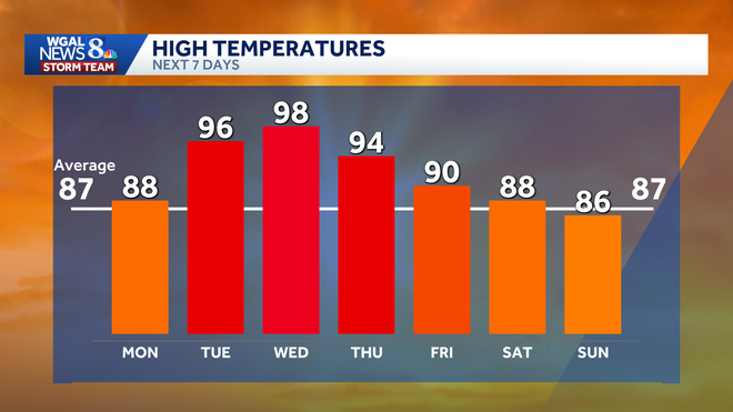
Temperatures are expected to run above the seasonal average of 87 degrees for much of the week:
Monday: 88Tuesday: 96Wednesday: 98Thursday: 94Friday: 90Saturday: 88Sunday: 86
Warm nights offer little relief
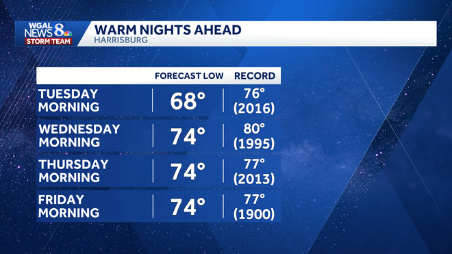
Overnight lows will provide limited relief, especially by midweek. In Harrisburg, forecast morning lows are:
Tuesday morning: 68Wednesday morning: 74Thursday morning: 74Friday morning: 74
While those readings remain below daily warm-low records, they will still add to the discomfort.
Heat eases later in the week
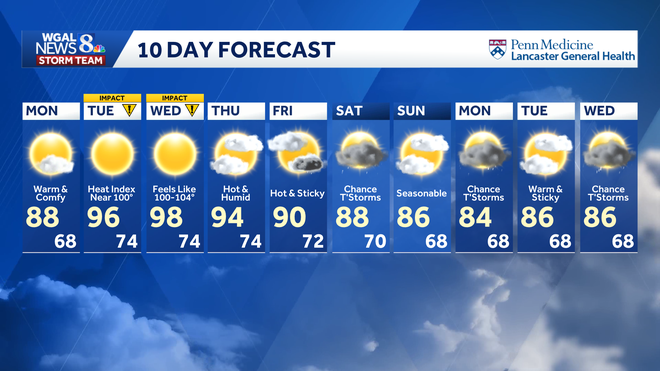
The heat is expected to ease somewhat by Thursday and Friday, though conditions will remain hot and humid.
Highs should reach about 94 on Thursday and 90 on Friday, with humidity beginning to drop by the end of the week. A slight chance of thunderstorms is also in the forecast for Friday.
Safety precautions
Residents are urged to take precautions during the heat wave, including:
Drink plenty of waterTake frequent breaks if working outdoorsWear light-colored, loose-fitting clothingLimit strenuous activity during the afternoonCheck on older adults, children and pets
Did you capture a moment that you would like to share with News 8? Send us your photos or videos at https://www.wgal.com/upload.