
Canadian wildfire smoke brings hazy skies to south-central Pennsylvania
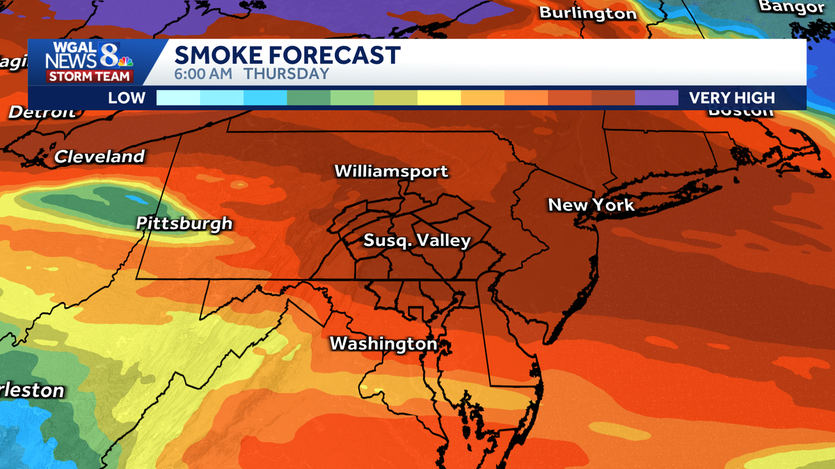
Maybe you noticed this yesterday. The Northeast is dealing with hazy skies because of wildfires in Canada. We’ve been through this before, right? Well, here’s *** look at New York City yesterday. Declining air quality is expected in some cities through tomorrow. Let’s go over to Christine now, who is tracking this right here in the Susquehanna Valley. Well, today in the Susquehanna Valley, here’s our air quality forecast. It is moderate, same thing that we’ve seen yesterday. We typically see moderate air quality. When we have the hot, humid days, it’s moderate for both ozone and particulate matter. Now tomorrow we’re still looking at moderate, maybe poor to our south. We’ll keep you updated on anything that changes because these things are really *** day by day wait and see situation. So when that smoke plume comes in tonight into tomorrow, we’ll have *** better idea of any surface air quality issues. But right now we’re looking good. In fact, we’re in between two plumes, one up to the north, one to the south that came through. Yesterday *** little hazy out there this morning, but not bad. I think we’re going to see more blue sky today and that’s going to allow our temperatures to warm. However, keep your eye on this plume here. It drops south tonight. This is 10:00 p.m. Overnight comes into the Susquehanna Valley and hangs out throughout the day tomorrow. That could really lower our temperatures and make the sky look milky white. So we’re going to watch that closely for you to see what kind of effects we have from that air. Quality and from that Canadian wildfire smoke. So our News 8 storm team forecast today says mostly sunny and muggy to start. Hazy sunshine this afternoon, feeling like the triple digits. We’re going to reach the upper 90s today, our hottest day of the heat wave. This evening. The haze thickens, hot and humid still, even at 8 o’clock. It’s going to be near 90 degrees tonight. We have the haze, the overcast skies with that smoke plume coming in, 74 to 78. Keeps us warmer at night. And look at the highs tomorrow. They will also be impacted. Instead of reaching the projected mid 90s, we might be stuck in the low 90s with that kind of overcast look to the sky. So 90 to 94 tomorrow. Still feeling like the mid to upper 90s when you factor in that humidity. Right now we have temperatures around 70 in Lancaster, 77 in Lewistown, 75 in Chambersburg. Our dew points are up well into the 60s, so it’s that combo of heat and humidity today that’s going to make it feel oppressive weather. And health update today. Notice the UV index is very high with more sun than we had yesterday. It’s *** burn time of 15 minutes. Here’s the storm team live radar Network. We’ve been talking *** lot about *** big dome of heat. It’s still right overhead, and that’s really the pressure cooker this week, giving us the heat, the humidity, and the sunshine today to give you high temperatures in the upper 90s. Now tonight, here comes *** front. It’s going to drop in from the north, maybe produce *** little cloud cover in addition to the smoke and haze, and then that front settles to our south. Tomorrow afternoon, notice there’s *** few showers that pop right along the state line south into Maryland and Virginia, so I’ll keep an eye on that, but I think we’re mainly dry tomorrow. For Friday, we still have *** little cloud cover overhead, but I’m still concerned that there could be some smoke and haze in the sky, and that may hold our temperatures down. But for today, here’s the predictor feels like temperatures. Notice they are the triple digits. It is the peak of the heat wave today. We should see more sunshine than we did yesterday. For tomorrow, not quite as hot, not quite as humid, so that. Is how much it, uh, how hot it feels, and we could see feels like temperatures mid 90s to upper 90s tomorrow. *** little bit of relief. By the time we hit Friday, our high is 92. It’s not as humid, very little impact from the heat index there. Saturday’s high is 86 with some scattered showers and thunderstorms around, *** slight chance on Sunday. And our next best chance would be next Tuesday with *** cold front coming in. But you know what, Regina, that cold front on Tuesday is going to lower the humidity. I think it’s going to feel quite nice Wednesday, perhaps Thursday, even into Friday. Not too bad.
Canadian wildfire smoke brings hazy skies to south-central Pennsylvania

Updated: 5:57 AM EDT Jul 15, 2026
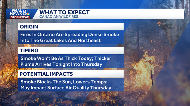
Wildfires burning in southern Ontario and northern Minnesota are sending a broad plume of smoke across the Great Lakes and into the Northeast, with hazy skies expected to linger for the next few days. The smoke is being carried southeast by upper-level winds flowing around a large ridge, or heat dome. That haze is filtering sunlight and helping to keep temperatures slightly lower. Air quality concernsRight now, there is no impact on surface air quality because the smoke is high in the atmosphere. However, if a denser plume settles closer to the ground, particulate pollution could rise and residents may notice a campfire-like smell. Below: Wednesday and Thursday’s air quality forecastDenser smoke possibleA thicker band of smoke could move into Pennsylvania late Wednesday and persist into Thursday morning. That could lead to:Hazy skies More vivid sunrises and sunsets Cooler daytime temperatures Possible deterioration in air quality Below: Swipe through the hour-by-hour smoke forecastWhat to watchWednesday’s smoke is not expected to be at its worst during the day, but thicker smoke is more likely tonight into Thursday. Air quality forecasts may be updated as conditions change. The WGAL News 8 Storm Team will continue to monitor the forecast and provide updates over the next few days.Did you capture the haze and would like to share with News 8? Send us your photos or videos at https://www.wgal.com/upload.
Wildfires burning in southern Ontario and northern Minnesota are sending a broad plume of smoke across the Great Lakes and into the Northeast, with hazy skies expected to linger for the next few days.
The smoke is being carried southeast by upper-level winds flowing around a large ridge, or heat dome. That haze is filtering sunlight and helping to keep temperatures slightly lower.
Air quality concerns
Right now, there is no impact on surface air quality because the smoke is high in the atmosphere.
However, if a denser plume settles closer to the ground, particulate pollution could rise and residents may notice a campfire-like smell.
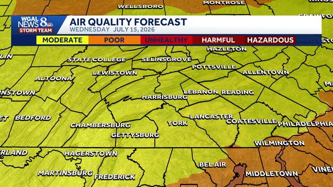
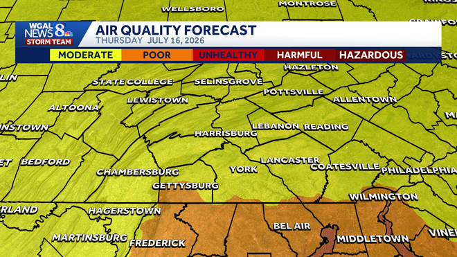
Below: Wednesday and Thursday’s air quality forecast
Denser smoke possible
A thicker band of smoke could move into Pennsylvania late Wednesday and persist into Thursday morning. That could lead to:
Hazy skies More vivid sunrises and sunsets Cooler daytime temperatures Possible deterioration in air quality
Below: Swipe through the hour-by-hour smoke forecast
What to watch
Wednesday’s smoke is not expected to be at its worst during the day, but thicker smoke is more likely tonight into Thursday. Air quality forecasts may be updated as conditions change.
The WGAL News 8 Storm Team will continue to monitor the forecast and provide updates over the next few days.
Did you capture the haze and would like to share with News 8? Send us your photos or videos at https://www.wgal.com/upload.