
Storms moving across the Lehigh Valley on Tuesday afternoon are dumping torrential rainfall, prompting the National Weather Service to issue a flash flood warning.
The warning is in effect until 5 p.m. for Northampton and south central Monroe counties. As of 3 p.m., weather service radar indicated up to 2.50 inches of rain had fallen, with the highest amounts in the area between Wind Gap and Pen Argyl.
A flash flood warning means flooding is ongoing or expected to begin shortly, according to the weather service. Flooding is most likely to occur on small creeks, highways and streets, as well as in low-lying, poor drainage and urban areas. Motorists are reminded to turn around if they encounter flooded roadways.
An earlier flash flood warning that extended into Lehigh County has since expired.
Minor flooding was reported along some roadways around the region, including Route 378 in Bethlehem.
Flooding isn’t the only threat Tuesday. One severe thunderstorm prompted a tornado warning for northeastern Northampton and east central Monroe counties until 2:15 p.m. Weather service radar indicated a severe thunderstorm capable of producing a tornado over Columbia, New Jersey at about 1:50 p.m.
After the storm, some residents on social media were reporting damage such as downed trees in the Bangor area. As of 4 p.m. Met-Ed reported around 443 outages in Upper Mount Bethel Township.
Earlier, the weather service issued a severe thunderstorm warning until 2 p.m. for east central Lehigh and Northampton counties. Route 863 between Loghouse and Danner roads in Weisenberg Township was closed due to multiple utility poles down from that storm.
The Lehigh Valley remains under a thunderstorm watch until 8 p.m. and a flood watch until 8 p.m. Wednesday.
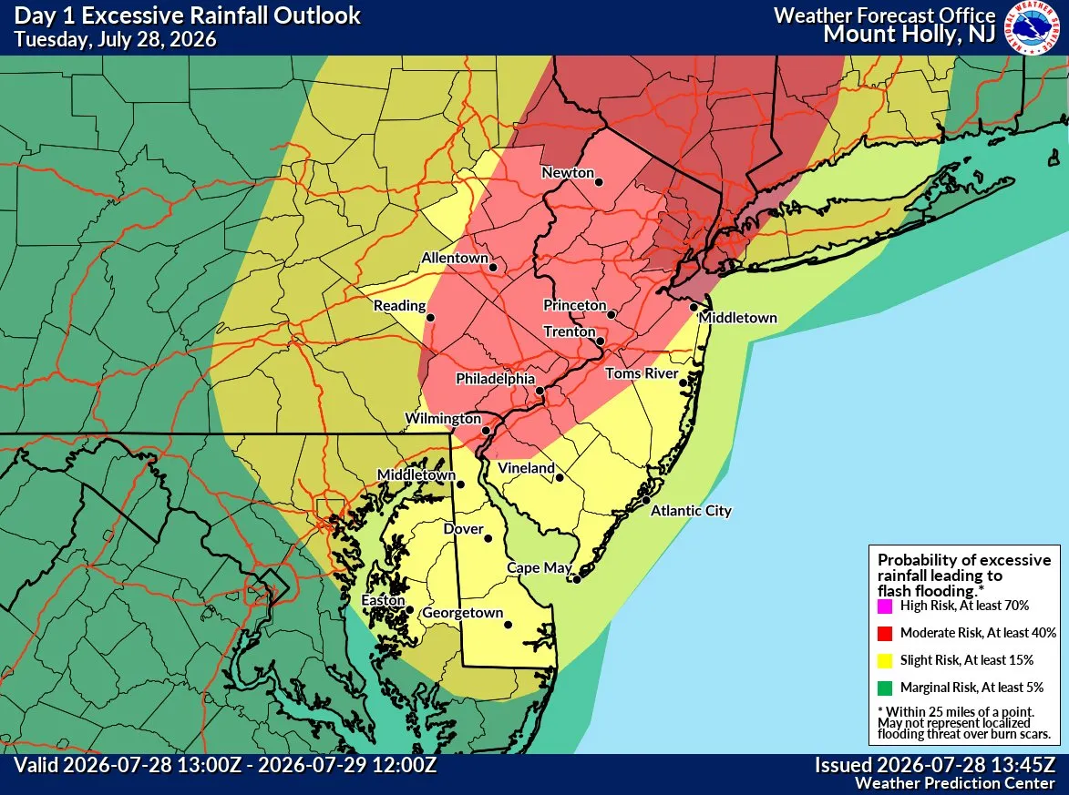
Good morning! We wanted to pass along a quick update to let you know that both the threat of severe weather and flash flooding for today continues to increase. #PAWX #NJWX #DEWX #MDWX pic.twitter.com/dfIln1V1w9
— NWS Mount Holly (@NWS_MountHolly) July 28, 2026
The flash flood warning came as the region was at a moderate risk of excessive rainfall that could cause flooding.
Almost all of the region, as well as neighboring Bucks, Berks and Montgomery counties, have at least a 40% chance of excessive rain, the National Weather Service in Mount Holly, New Jersey, said in an update Tuesday morning.
Additionally, the southern portion of the Lehigh Valley is at a slight risk of severe weather. The northern part is at a marginal risk, forecasters said.
A significant weather system is expected to continue producing thunderstorms throughout the afternoon. There could be multiple rounds of widespread showers and thunderstorms through the afternoon and evening, forecasters warned. Rainfall rates between 1 and 3 inches per hour are also possible. Up to 5 inches of rain could fall by the end of Wednesday.
Rain is expected to continue into Wednesday night and possibly linger into Thursday morning. Friday and Saturday should be clear.
Here is the extended forecast from the National Weather Service:
Wednesday: A chance of showers and thunderstorms, then showers likely and possibly a thunderstorm after 3 p.m. Increasing clouds, with a high near 80. West wind 5 to 10 mph. Chance of precipitation is 60%. New rainfall amounts of less than a tenth of an inch, except higher amounts possible in thunderstorms.
Thursday: A chance of showers, with thunderstorms also possible after 5 p.m. Partly sunny, with a high near 80. North wind around 10 mph, with gusts as high as 20 mph. Chance of precipitation is 40%. New rainfall amounts of less than a tenth of an inch, except higher amounts possible in thunderstorms.
Friday: Mostly sunny, with a high near 83.
Saturday: Mostly sunny, with a high near 86.
Sunday: A chance of showers and thunderstorms. Mostly cloudy, with a high near 86. Chance of precipitation is 50%.
Monday: A chance of showers and thunderstorms. Partly sunny, with a high near 85. Chance of precipitation is 40%.