
Strong winds expected Wednesday in South-Central Pa.
WE HAVE A WIND ADVISORY ISSUED FOR ALL OF THE SUSQUEHANNA VALLEY FROM 1:00 TODAY UNTIL 10 A.M. TOMORROW. SO I THINK THE STRONGEST WINDS ARE GOING TO COME LATE THIS EVENING AND TONIGHT WITH THE PASSAGE OF A STRONG COLD FRONT. THAT FRONT WILL BRING VERY LITTLE RAIN, BUT IT WILL BRING GUSTY WINDS. WE COULD HAVE SOME GUSTS BETWEEN 40 AND 50MPH LATE. HERE’S THE PREDICTOR. SUSTAINED WINDS SHOWING THAT THIS AFTERNOON THEY’LL START TO PICK UP OUT OF THE SOUTH AND SOUTHWEST AT ABOUT 10 TO 20MPH. INITIALLY. THAT’S WHERE WE’RE GOING TO BOOST OUR TEMPERATURES INTO THE UPPER 60S FOR HIGHS. THEN THE WIND SWITCHES DIRECTION AS THIS COLD FRONT COMES THROUGH LATE AND LOOK AT THE SUSTAINED WINDS. THEY COULD BE 20 TO 25MPH AFTER DARK. FINALLY, THE WINDS DO DIE DOWN TOMORROW MORNING AND WE SHOULD SEE JUST A LIGHT BREEZE BY TOMORROW AFTERNOON. HERE’S THE WIND GUSTS. YOU CAN SEE THEM IN THE 20 MILE PER HOUR RANGE. INITIALLY, AS THE WINDS PICK UP, BUT THE GUSTS COULD BE BETWEEN 40 AND 50MPH. WITH THE PASSAGE OF THAT COLD FRONT LATE. THIS IS AT 11 P.M., SO I’D SAY BETWEEN 8 AND 11. THAT’S WHEN THE STRONGEST WINDS AND THE STRONGEST WIND GUSTS WILL BE COMING THROUGH THE SUSQUEHANNA VALLEY LATE TODAY. LET’S TALK ABOUT OUR NEWS EIGHT STORM TEAM FORECAST. WE’LL GO WITH A HIGH TEMPERATURE. GET THIS OF ALMOST 70. IT’S GOING TO BE OUR WARMEST DAY OF THE WEEK. WE HAVE INCREASING CLOUDS LATER THIS AFTERNOON AFTER PLENTY OF SUNSHINE AND THEN JUST A COUPLE OF SHOWERS WITH THAT FRONT. IF YOU SEE ANYTHING AT ALL THIS EVENING FOR TONIGHT DECREASING CLOUDS, WE’LL HAVE THOSE GUSTS 40 TO 50MPH EARLY, AND THERE MAY BE JUST A STRAY LINGERING SHOWER IN NORTHERN COUNTIES. TEMPERATURES WILL BE WARMER IN THE 40S OVERNIGHT. TOMORROW. PARTLY SUNNY, BREEZY, COOLER INSTEAD OF 60S. WE’RE GOING DOWN TO THE 50S BEHIND THAT COLD FRONT, AND IT’S GOING TO BE A MORE SEASONABLE DAY. MORE TYPICAL DAY FOR NOVEMBER. RIGHT NOW YOU SEE SOME 30S ON THE MAP, A COUPLE OF 40S. IT IS A COOLER MORNING COMPARED TO YESTERDAY. WE’VE HAD MAINLY CLEAR SKIES OVERNIGHT. JUST A COUPLE OF CLOUDS CRUISING BY. SO THAT’S THE REASON FOR THE CHILLY TEMPERATURES. HERE’S OUR STORM TEAM LIVE RADAR NETWORK. ON THE BIGGER PICTURE, YOU CAN BARELY TELL WHERE THIS COLD FRONT IS, BUT IT’S STILL BACK OUT IN THE MIDWEST. AND THAT’S THE FRONT THAT WILL PROVIDE THE PUNCH WITH THE WIND AND JUST A STRAY SHOWER CHANCE LATER THIS EVENING. SO HERE WE GO TODAY. IT WARMS UP, THE CLOUDS COME IN AND HERE COMES THAT POWERFUL COLD FRONT WITH THE STRONG, GUSTY WINDS BEHIND IT. IT’S STILL WINDY TOMORROW MORNING, BUT ONLY A LITTLE BIT. I THINK THE WINDS QUICKLY DECREASE AFTER THE MORNING RUSH AS HIGH PRESSURE BUILDS IN, SO THAT WILL LOCK IN THE CALMER CONDITIONS FOR YOU BY THURSDAY AFTERNOON. FRIDAY LOOKS GOOD. INCREASING CLOUDS THROUGHOUT THE DAY. THE RAIN HOLDS OFF UNTIL LATE IN THE DAY, SO IF YOU HAVE FRIDAY PLANS YOU SHOULD BE FINE. THE RAIN SHOWERS COME IN AFTER DARK. HERE’S A LOOK AT THAT TEN DAY FORECAST. I THINK MOST OF THE SHOWERS CLEAR OUT EARLY SATURDAY. SUNDAY WE HAVE ANOTHER CHANCE OF RAIN WITH A STRONGER COLD FRONT COMING IN. LOOK AT THE TEMPERATURE DROP FROM 60 ON SUNDAY DOWN INTO THE 40S ON MONDAY AND TUESDAY. NOW THAT’S COLD STUFF. GABRIEL WE HAVEN’T BEEN
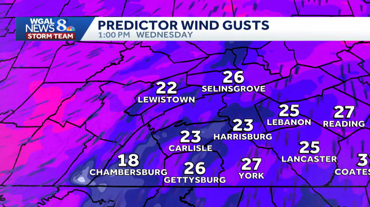
South-Central Pennsylvania is gearing up for a windy Wednesday as a Wind Advisory goes into effect this afternoon through Thursday morning.The WGAL News 8 Storm Team has designated Wednesday and Wednesday night as an Impact Day, meaning the weather could disrupt your normal daily schedule or routine. Here’s what to expect:Wind alerts in effectWind Advisory: 1 p.m. Wednesday to 10 a.m. Thursday for Lancaster, York, Lebanon, Dauphin, Perry, Mifflin, Juniata, Cumberland, Adams, and Franklin counties. Wind gusts and potential impactsSusquehanna Valley: Wind gusts could exceed 40-50 mph starting Wednesday evening and continuing through early overnight. These winds may:Bring down power lines and small tree limbs.Topple lawn furniture and yard decorations. Weather details for WednesdayDaytime: Sunshine will dominate early, with increasing clouds by evening as a cold front approaches. It will turn breezy to windy.Evening and overnight: A few showers are expected late Wednesday evening through the night. This is when the strongest wind gusts will occur. Temperatures: Highs will be the warmest of the week, reaching the upper 60s to near 70 degrees.Prepare for strong winds, secure outdoor items, and exercise caution while traveling, especially in areas under the High Wind Watch.
South-Central Pennsylvania is gearing up for a windy Wednesday as a Wind Advisory goes into effect this afternoon through Thursday morning.
The WGAL News 8 Storm Team has designated Wednesday and Wednesday night as an Impact Day, meaning the weather could disrupt your normal daily schedule or routine.
Here’s what to expect:
Wind alerts in effectWind Advisory: 1 p.m. Wednesday to 10 a.m. Thursday for Lancaster, York, Lebanon, Dauphin, Perry, Mifflin, Juniata, Cumberland, Adams, and Franklin counties. Wind gusts and potential impacts
Susquehanna Valley: Wind gusts could exceed 40-50 mph starting Wednesday evening and continuing through early overnight. These winds may:Bring down power lines and small tree limbs.Topple lawn furniture and yard decorations.
Weather details for WednesdayDaytime: Sunshine will dominate early, with increasing clouds by evening as a cold front approaches. It will turn breezy to windy.Evening and overnight: A few showers are expected late Wednesday evening through the night. This is when the strongest wind gusts will occur. Temperatures: Highs will be the warmest of the week, reaching the upper 60s to near 70 degrees.
Prepare for strong winds, secure outdoor items, and exercise caution while traveling, especially in areas under the High Wind Watch.