
SHORT TERM FORECAST
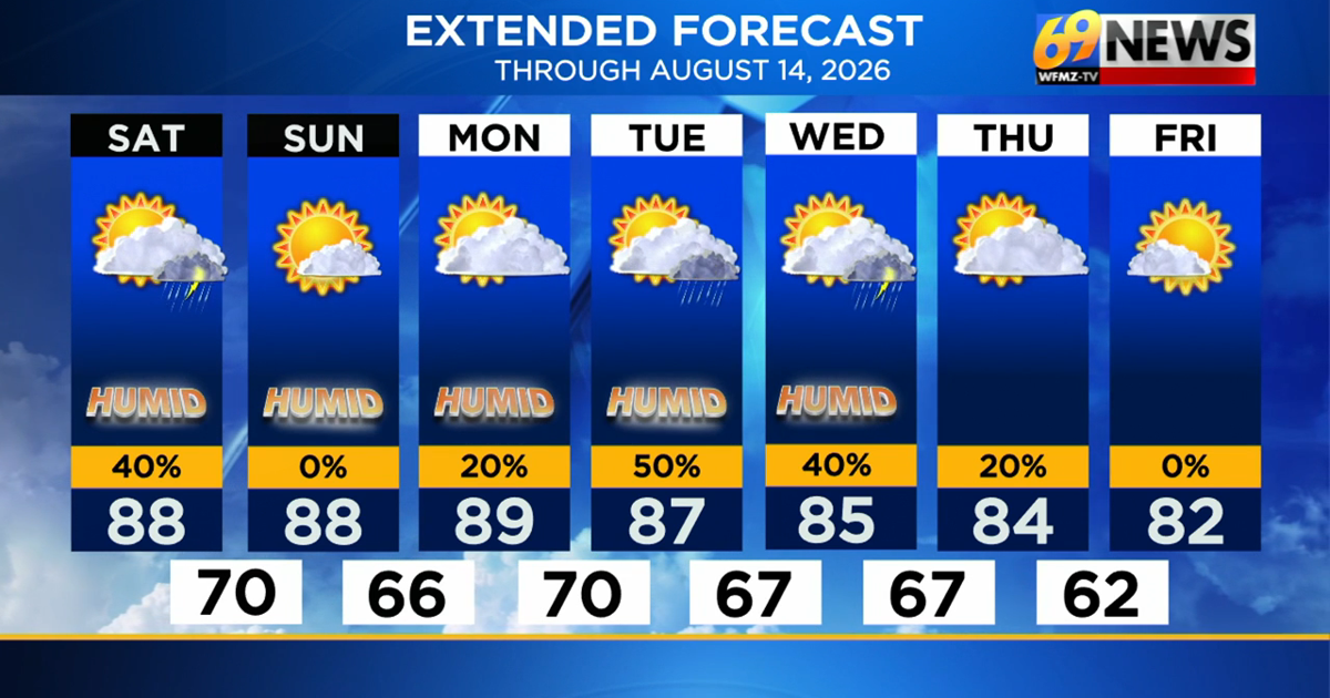
SATURDAY: Partly sunny, unseasonably warm, and humid with a shower or thunderstorm in the afternoon. High: 88
SATURDAY NIGHT: An evening shower or t-storm, then partly cloudy, warm, and muggy; areas of fog redeveloping. Low: 70
SUNDAY: Warm and humid under mostly sunny skies. Our first completely dry day. High: 90
FORECAST SUMMARY
After an active second half to the day on Friday, we go into Saturday looking to receive a slightly drier day. Shower and storm activity will be more scattered than that of yesterday, though we are still under a marginal risk for severe weather. While heavy downpours and localized flooding is the primary concern with any storms given the high humidity, a gusty thunderstorm with strong and damaging wind gusts is possible. Any activity will begin to subside by dusk and start a clearing out of the cloud cover to lead us into a dry, mostly sunny Sunday. It’ll remain warm and muggy through this weekend, with highs in the upper 80s for both days. With the high humidity and temperatures in the upper 60s to 70 degrees both nights, patchy fog will develop late each night. Looking ahead to next week, we’ll still be above seasonable in the upper 80s and humid through Wednesday, with pop-up thunderstorms returning to the forecast for Tuesday and Wednesday afternoons. Relief is looking to come at the end of next week, with dewpoints beginning to fall, and temperatures dropping to the 80-degree mark.
DETAILED FORECAST
SATURDAY
Once the morning fog burns off, we’ll begin the weekend with some hazy sunshine, offering a few hours of sunlight to help provide fuel for some storm development come this afternoon. Temperatures will peak in the upper 80s by the afternoon, and with dewpoints around 70 degrees yet again, expect the heat index to climb as high as 95 degrees. This is a slight relief from where we have been the last few days, though still warm. Today’s showers and thunderstorms will remain scattered in nature, looking to cover less areas and remaining fewer in quantity than the storms that effected the Lehigh Valley late Friday afternoon. We are still under a marginal risk for severe weather from the Storm Prediction Center today. The night looks warm and muggy once again with some areas of fog redeveloping and lows around 70 degrees.
SUNDAY AND MONDAY
We may get a two-day reprieve from those daily thunderstorm chances for Sunday and Monday, as both days look largely dry and storm-free. It will remain warm and humid with highs remaining in the upper 80s each afternoon, and the heat index likely creeping just over the 90-degree mark. The humidity may drop off just a bit late Sunday and Sunday night to less oppressive levels, but stop short of dropping into comfy levels. We may have to wait until the end of next week for those.
TUESDAY AND WEDNESDAY
A new front may get stuck somewhere close to us for the middle of next week, keeping the warm and humid air mass in place, and serving as a focal point for a few more scattered showers and thunderstorms. Highs will settle back just a tad into the mid 80s, and while no washouts are expected, some daily thunderstorm chances will pop back into the forecast for Tuesday and Wednesday, and perhaps Thursday as well. Drier and comfier weather will eventually await once the front settles far enough south, but that may not be until Friday.
TRACK THE WEATHER:
LINKS: HOUR BY HOUR | RADAR | TRAFFIC