

In some parts of the region, it did not officially become a heat wave, while in others it did according to National Weather Service Mount Holly, N.J. office data.
On Saturday, the Allentown and Reading areas only hit highs of 86 degrees at both airports, thus breaking the days in a row of 90 degrees or higher required to become a NWS heat wave. No precipitation registered at Lehigh Valley International Airport and just .01 of an inch registered at Reading Regional Airport.
Philadelphia and Trenton officially did reach heat wave status with 91 degrees registering in Philly and 90 at Trenton-Mercer airport. Tiny amounts of rain were observed, .02 in Trenton and .07 in Philadelphia.
Thermometers throughout the region are expected to rise to 88 in the Chester County area to 93 degrees in Delaware, Philadelphia and Mercer (N.J.) counties today, with possible isolated showers and thunderstorms according to the NWS forecast. The Berks and Montgomery counties highs are expected to be 91
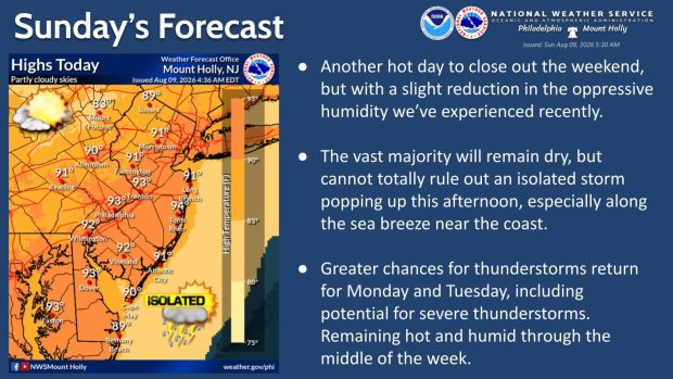
NWS forecast for Reading area
Today: Sunny, with a high near 91. West wind 5 to 10 mph.
Tonight: Mostly clear, with a low around 69. West wind around 5 mph becoming calm in the evening.
Monday: A slight chance of showers, then a chance of showers and thunderstorms after noon. Mostly sunny, with a high near 91. Light southwest wind increasing to 5 to 10 mph in the afternoon. Winds could gust as high as 20 mph. Chance of precipitation is 40%. New rainfall amounts of less than a tenth of an inch, except higher amounts possible in thunderstorms.
Monday night: A chance of showers and thunderstorms before 2 a.m. Mostly cloudy, with a low around 71. West wind 5 to 10 mph. Chance of precipitation is 30%. New rainfall amounts between a quarter and half of an inch possible.
Tuesday: Showers likely and possibly a thunderstorm after 2 p.m. Partly sunny, with a high near 88. West wind around 5 mph. Chance of precipitation is 60%. New rainfall amounts between a tenth and quarter of an inch, except higher amounts possible in thunderstorms.
Tuesday night: Showers likely and possibly a thunderstorm before 8pm, then a chance of showers and thunderstorms between 8 p.m. and 2 a.m., then a chance of showers after 2 a.m. Mostly cloudy, with a low around 68. Chance of precipitation is 60%. New rainfall amounts of less than a tenth of an inch, except higher amounts possible in thunderstorms.
Wednesday: A chance of showers and thunderstorms after 2 p.m. Partly sunny, with a high near 86. Chance of precipitation is 40%.
Wednesday night: A chance of showers and thunderstorms before 2 a.m. Mostly cloudy, with a low around 67. Chance of precipitation is 40%.