
Strong winds overnight led to thousands of power outages Thursday morning across the Lehigh Valley region.
The National Weather Service reports wind gusts peaked at 53 mph about 10 p.m. at Lehigh Valley International Airport outside Allentown.
As of 8 a.m., PPL Electric Utilities reported 4,886 outages across Bucks, Carbon, Lehigh, Monroe and Northampton counties, with Lehigh and Monroe counties hardest-hit at nearly 1,500 and more than 1,800 outages each, respectively.
FirstEnergy Corp.’s Met-Ed reported 947 outages in Bucks County, 1,049 in Monroe and 1,487 in Northampton.
Across the Delaware River, FirstEnergy’s JCP&L reported 1,129 outages in Hunterdon County and 2,289 in Warren County.
Combined, those outages across the seven counties affected nearly 12,000 customers. Systemwide as of Thursday morning, PPL reported 20,000 outages; Met-Ed, about 22,000; and JCP&L, 7,713.
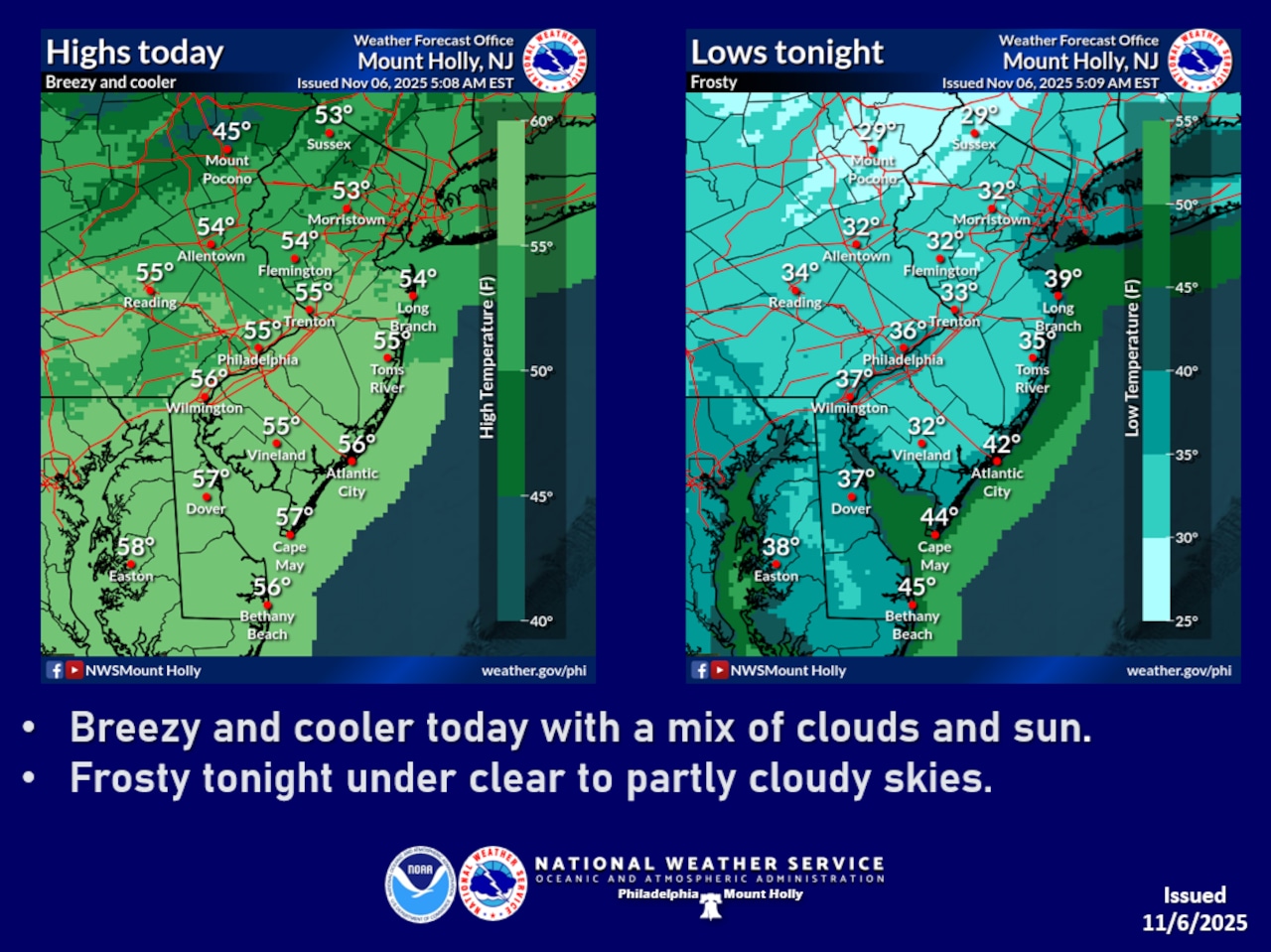
A seasonably chilly fall day is forecast for Thursday in the Lehigh Valley. The National Weather Service forecast indicates a cold air mass is moving through the region.
Northwest winds will continue to be breezy throughout Thursday, with occasional gusts of 20 to 30 mph. Daytime high temperatures will remain in the 50s, with increasing clouds and winds becoming calm Thursday night.
Low temperatures near or below the 32-degree freezing mark are forecast overnight into Friday morning.
Residents should take precautions to protect sensitive plants and vegetation during the overnight hours. Outdoor potted plants, gardens, and tender crops are particularly vulnerable to frost damage. Cover sensitive plants or bring them indoors to prevent potential frost-related harm.
The weather pattern will begin to moderate on Friday, with southwesterly winds bringing milder air into the region. High temperatures will climb into the 50s north of Interstate 78 and reach the 60s in southern areas.
A weak front will move through Friday night, potentially bringing light showers, with amounts expected to be minimal, less than a quarter-inch.
The weekend outlook shows a warming trend, with Saturday’s temperatures expected to reach the 60s and approach 70 degrees in some locations. However, a stronger cold front is expected to arrive Sunday, bringing rain and significantly cooler temperatures for early next week. Highs will drop into the 40s with potential for widespread freezing conditions overnight Monday into Tuesday.
Follow your local forecast from AccuWeather at lehighvalleylive.com/weather with National Weather Service watches, warnings and other advisories available as they’re issued at lehighvalleylive.com/weather-alerts.
Current weather radar
Supervising reporter Kurt Bresswein contributed to this report. Reach him at kbresswein@lehighvalleylive.com. Generative AI was used to draft segments of this report, which was reviewed and edited by lehighvalleylive.com staff.
If you purchase a product or register for an account through a link on our site, we may receive compensation. By using this site, you consent to our User Agreement and agree that your clicks, interactions, and personal information may be collected, recorded, and/or stored by us and social media and other third-party partners in accordance with our Privacy Policy.