
Showers and a few isolated rumbles of thunder move through the Philadelphia area overnight as a strong cold front crosses the region.
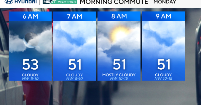
Temperatures fall into the 40s overnight, with 30s across the Poconos once the colder air begins filtering in. By Monday morning, skies turn mostly cloudy and a brisk northwest wind develops behind the front.

CBS News Philadelphia
Monday will feel much colder, with highs peaking in the mid-40s to mid-50s by midday before temperatures begin to drop. Winds will gust up to 25 mph, and lingering clouds will keep conditions gray and chilly. A few stray flurries can’t be ruled out in the higher elevations. Wind chills will dip into the 20s and 30s by late afternoon, marking the first true taste of winter air this season.
That colder air deepens Monday night into Tuesday, bringing lows below freezing across nearly all areas except the immediate coast.

CBS News Philadelphia
Gusty northwest winds continue Tuesday with highs only in the low to mid-40s and 30s in the hills. The rest of the week stays dry and breezy, with a brief warm-up Wednesday ahead of another weak front, followed by cool, seasonable weather through next weekend.
Here’s your 7-day forecast:

CBS News Philadelphia
Monday: Turning colder. High 49.
Tuesday/Veterans Day: The big chill. High 46, Low 31.
Wednesday: Much milder. High 56, Low 37.
Thursday: Mostly sunny. High 56, Low 43.
Friday: Partly cloudy. High 59, Low 37.
Saturday: Partly cloudy. High 52, Low 36.
Sunday: Partly cloudy. High 63, Low 40.
More from CBS News