
SHORT TERM FORECAST
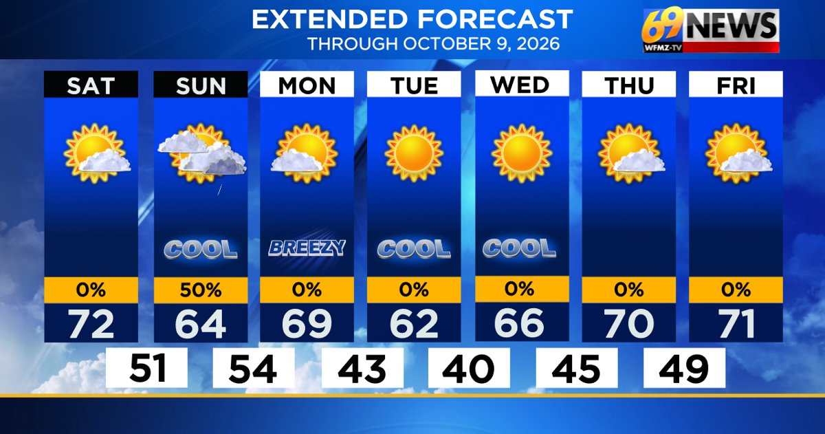
SATURDAY: Mostly sunny and more seasonable; a dry and pleasant day. High: 72
SATURDAY NIGHT: Mostly clear; some clouds increase towards morning. Low: 51
SUNDAY: Becoming mostly cloudy with a scattered shower or two in the afternoon. High: 64 Low: 54
FORECAST SUMMARY
The first weekend of October is looking much nicer than the rain, drizzle, and wind we had last weekend from our late September nor’easter. Saturday gets the nod as the better of the two weekend days, with sunny skies and seasonable temperatures. While it will be much cooler than the low to mid 80s we saw on Friday, it will feel more autumnal with more seasonable highs in the low 70s. We’ll hit a little bump in an otherwise nice weather road on Sunday, with more clouds, cooler temperatures, and perhaps a few scattered and light afternoon or evening rain showers. It’s certainly not enough rain to cancel any plans over, and it may be the only rain in an otherwise dry stretch of weather that looks to last through most of next week. So abundant sunshine should be the rule from Monday through at least Friday next week, perhaps into the start of next weekend too. While it will be a bit breezy Monday and a bit cool Tuesday and Wednesday (perhaps a hint of frost Tuesday night in the normally colder spots?), it looks sunny and dry all the while. The Atlantic Ocean continues to be void of any tropical activity, as we continue through likely the quietest hurricane season on record. Enjoy the nice weather, and have a great weekend!

DETAILED FORECAST
SATURDAY
The weekend gets off to a great start on Saturday, with mostly sunny skies and seasonably mild temperatures expected. Look for a dry and pleasant day with highs in the low 70s, a good 10+ degrees cooler than Friday but still a nice day all around! Winds will be light from the northeast around 10mph.
SATURDAY NIGHT
Expect most of the night to be mostly clear and comfortably cool with lows down in the low 50s. Some clouds will increase from the south well after midnight and towards sunrise Sunday morning, but the night will remain dry throughout.
SUNDAY
Sunday may bring the only chance of rain for the next seven days, but it’s not a huge chance and the rain shouldn’t amount too much. While there could be a little sun early Sunday morning, especially north of the Lehigh Valley, look for skies to become mostly cloudy for the better part of the day. As a result, it’s a cooler day overall with highs only in the mid 60s. From midday on, a few light and scattered rain showers are possible, more likely the farther south from I-78 you travel. For many, it’s enough rain to wet the ground, maybe a few hundredths of an inch of rain, with a little more rain towards the Delaware Valley and the shore. Any showers should end during the evening, with skies clearing later Sunday night.
MONDAY
The new work and school week should begin with a mostly sunny day on Monday, a sign of things to come the rest of the week. It will be a little breezy, with northwest winds around 10-15mph and a little gusty at times as some cooler air will be ushered in. Highs on Monday will be in the upper 60s, with the coolest weather to come for the middle of the upcoming week. Monday night looks clear and quite cool with diminishing winds, and lows well down into the 40s.
TUESDAY AND WEDNESDAY
Here’s the coolest part of our forecast, with perhaps the chance for a little frost in a few spots too. Both Tuesday and Wednesday should feature abundant sunshine, with hardly a cloud in sight. Winds will be light, and temperatures rather cool despite the plentiful sun. Tuesday’s highs will only be in the low 60s, with mid 60s on Wednesday (average high for early October is in the low 70s). But while cool, look for some clear, crisp, and quiet early fall weather through the middle of the week. Tuesday night will be the coolest night of the week, with clear skies and light winds and lows either side of 40 degrees. Some of the normally cooler spots, like the Poconos, far North Jersey, and sheltered valleys, could drop into the mid to upper 30s with a hint of frost.
THURSDAY AND FRIDAY
The cool air mass begins to moderate, with highs back up near 70 degrees by the end of the week, with plentiful sunshine all the while. While still cool, nights will moderate a bit too, with lows around 45-50 degrees by week’s end. There’s no rain in sight through at least next Saturday, and even Sunday looks mostly dry at this point too for the Columbus Day holiday weekend.
TRACK THE WEATHER:
LINKS: HOUR BY HOUR | RADAR | TRAFFIC