
Western Pennsylvania getting its coldest air of the season this week
S█TOCKHOLM, AND WE’RE KIND OF GETTING INTO THE WINTER SPIRIT HERE A LITTLE EARLY IN THE SEASON, AS WE HAVE NOW SEEN THE COLDEST AIR OF THE SEASON SHOW UP IN WESTERN PENNSYLVANIA. ALSO, SOME SCATTERED FLURRIES ON THE MENU AS WE GO THROUGH YOUR MONDAY. TOMORROW IS AN IMPACT DAY. AT LEAST START VETERAN’S DAY. IT FEELS LIKE TEMPERATURES WILL BE DOWN INTO THE TEENS. A LOT OF THOSE FLURRIES BREAKING DOWN AND EVENTUALLY TEMPERATURES WILL RECOVER AS WE TOWARDS THE SECOND HALF OF THE WEEK. FOR MOST OF US, NOT EXPECTING MUCH SNOW TO STICK, ESPECIALLY ON OUR ROADS, BRIDGES AND OVERPASSES. BUT THINGS COULD GET A LITTLE TRICKY IN THOSE TYPICAL SNOWBELT AREAS OF WESTERN PENNSYLVANIA. TALKING ABOUT UP ALONG I-80, ALSO THROUGH THE RIDGES, EVEN PARTS OF NORTHERN WEST VIRGINIA AND WESTERN MARYLAND, YOU’RE ALL UNDER A WINTER WEATHER ADVISORY THAT STARTS AT 1:00 TODAY, RUNS THROUGH 1:00 TOMORROW AFTERNOON. SO JUST HOW MUCH SNOW IS GOING TO STICK? OF COURSE, AS THE FIRST FLAKES OF THE SEASON, EVERYBODY KIND OF GETS A LITTLE EXCITED. BUT AGAIN, FOR THE MOST PART, THESE ACCUMULATIONS NOT GOING TO BE A WHOLE LOT IF YOU HAPPEN TO SEE SOME SNOW, MORE THAN LIKELY JUST A DUSTING, MAYBE A SKIFF ON THE GRASS IN YOUR MULCH BEDS, EVEN THE ROOFTOPS AS WELL. BUT THINGS COULD START TO PICK UP, ESPECIALLY NORTH OF 422, CLOSER TO I-80 INTO THE RIDGES AS WELL. THE LAUREL HIGHLANDS TALKING ABOUT INTO WESTMORELAND, FAYETTE COUNTIES. WITH THAT RISE IN ELEVATION, YOU COULD SEE ANYWHERE FROM 1 TO 2IN. ONCE THINGS ARE WRAPPING UP AROUND MIDDAY TOMORROW. BUT BEFORE WE GET THERE, SOME BITING WIND CHILLS PROMPTING THAT IMPACT DAY TOMORROW, AS FEELS LIKE TEMPERATURES DOWN INTO THE TEENS, POSSIBLY EVEN THE SINGLE DIGITS. SO CERTAINLY YOU’RE LAYERING UP IF YOU ARE HEADING TO SOME EARLY VETERANS DAY CEREMONIES IN THE MORNING. DOESN’T FEEL MUCH BETTER INTO THE AFTERNOON AS FEELS-LIKE TEMPS WILL ONLY BE IN THE 20S, BUT THEN WE’RE SKIPPING RIGHT AHEAD INTO THE UPPER 40S, CLOSE TO 50. DURING THE SECOND HALF OF THE WEEK. WE DO HAVE SOME SCATTERED SNOW SHOWERS OUT THERE RIGHT NOW. GOOD LITTLE BURST, AT LEAST ACROSS PARTS OF THE AREA SOUTH OF MASONTOWN OVER TOWARDS UNIONTOWN, AS WELL INTO FAYETTE COUNTY. STILL SOME FLURRIES HANGING ON AS THE RADAR BEAM IS COMING BY. AS WE ZOOM BACK TOWARDS WAYNESBURG AND ALSO EAST FINDLAY IN WASHINGTON COUNTY. THIS BAND BETWEEN KITTANNING AND INDIANA STARTING TO BREAK DOWN. THAT’S ALL SOUTH OF 422, BUT STILL A FEW MORE FLURRIES TRYING TO GET THEIR ACT TOGETHER. COMING OUT OF NEWCASTLE, DRIFTING THROUGH BEAVER AND BUTLER COUNTIES AS WELL. SO LET’S PLAY THINGS OUT HERE. AS YOU WILL SEE THOSE SOUTHERN SNOW SHOWERS STARTING TO WRAP UP HERE OVER THE NEXT COUPLE OF HOURS. MAYBE A LITTLE BIT OF A BREAK AROUND MIDDAY, BUT THEN THE LAKE EFFECT SNOW MACHINE GETS GOING AND YOU CAN SEE THAT BAND ALREADY STARTING TO SET UP ACROSS PARTS OF MERCER AND VENANGO COUNTIES. THAT’S WHEN WE COULD START TO SEE SOME IMPACTS ON TRAVEL, ESPECIALLY ALONG I-80. AGAIN, NOT GOING TO BE A WHOLE LOT OF SNOW, BUT IF YOU HAPPEN TO SEE ANY ACCUMULATE, IT’S GOING TO BE LATER ON THIS EVENING THROUGH THE OVERNIGHT HOURS, EVERYTHING PRETTY MUCH WRAPPING UP AS YOU WAKE UP ON VETERANS DAY TOMORROW. CLOUDS GOING TO BE A LITTLE BIT STUBBORN IN THE MORNING. SHOULD INTRODUCE SOME SUNSHINE AND WE WILL CONTINUE TO BRIGHTEN UP AS TEMPERATURES MODERATE INTO THE SECOND HALF OF THE WEEK. WE’RE AT 52 BY FRIDAY, AND AS WE CHECK OUT THE REST OF YOUR 4-DAY PLUS 4 MORE FORECAST, OF COURSE, ALL EYES ON THE NORTH SHORE OVER THE WEEKEND PIT IN THE NATIONAL SPOTLIGHT. STEELERS ALSO IN TOWN AGAINST THE BENGALS. THERE COULD BE A SYSTE
Western Pennsylvania getting its coldest air of the season this week

Updated: 7:27 AM EST Nov 10, 2025
Winter makes its debut in the Pittsburgh area with scattered flurries and biting wind chills over the next two days. Temperatures will recover close to 50 degrees by late week with sun and clouds.The first flakes of the season More flurries and isolated light snow showers will kick in today, and continue in off and on fashion through mid-day Tuesday. Some heartier bands will develop this afternoon and evening, especially for the I-80 corridor and the ridges. If any snow is going to accumulation, that’s when it will begin. SEE THE SNOW IN FAYETTE COUNTY Moisture looks pretty limited and the ground is still relatively warm. Snowflakes will have a hard time sticking, especially to paved surfaces. The grass, mulch beds, and rooftops could be dusted by very light accumulations, especially near I-80 and through the Laurels. These areas – including the higher terrain of Fayette and Westmoreland counties, along with forest, Mercer, Venango, Preston and Tucker counties – go under a Winter Weather Advisory at 1 p.m. today and will run through 1 p.m. Tuesday. The coldest air of the season, Impact Day Tuesday morningThe coldest air of the season will linger into Veterans Day. It is another Impact Day for morning feels like temperatures in the teens. A few more flurries are possible north into Tuesday afternoon. This Arctic blast will linger with highs in the mid 30s again. Temperatures recover late weekAfter a cold start to the week, temperatures will recover during the second half of next week. We are tracking highs around 50 degrees starting Wednesday. The pattern will settle down and stay dry too. We will watch a rain-making system to arrive late next weekend into the start of next week. TODAY: Scattered flurries, breezy and colder with feels like temperatures in the 20s. High: 36°.TONIGHT: Scattered snow showers, especially north near I-80. Low: 26°.TUESDAY – Impact Day: Morning feels like temperatures in the teens. Flurries north, mostly cloudy. High: 37°, low: 31°.WEDNESDAY: Mostly cloudy, brisk and breezy. High: 47°, low: 35°.THURSDAY: Partly cloudy and still cool. High: 48°, low: 33°.
Winter makes its debut in the Pittsburgh area with scattered flurries and biting wind chills over the next two days. Temperatures will recover close to 50 degrees by late week with sun and clouds.
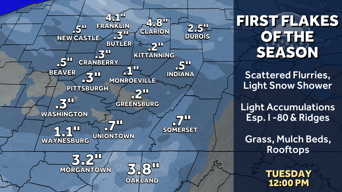
The first flakes of the season
More flurries and isolated light snow showers will kick in today, and continue in off and on fashion through mid-day Tuesday. Some heartier bands will develop this afternoon and evening, especially for the I-80 corridor and the ridges. If any snow is going to accumulation, that’s when it will begin.
SEE THE SNOW IN FAYETTE COUNTY
Moisture looks pretty limited and the ground is still relatively warm. Snowflakes will have a hard time sticking, especially to paved surfaces. The grass, mulch beds, and rooftops could be dusted by very light accumulations, especially near I-80 and through the Laurels. These areas – including the higher terrain of Fayette and Westmoreland counties, along with forest, Mercer, Venango, Preston and Tucker counties – go under a Winter Weather Advisory at 1 p.m. today and will run through 1 p.m. Tuesday.

The coldest air of the season, Impact Day Tuesday morning
The coldest air of the season will linger into Veterans Day. It is another Impact Day for morning feels like temperatures in the teens. A few more flurries are possible north into Tuesday afternoon. This Arctic blast will linger with highs in the mid 30s again.

Temperatures recover late week
After a cold start to the week, temperatures will recover during the second half of next week. We are tracking highs around 50 degrees starting Wednesday. The pattern will settle down and stay dry too. We will watch a rain-making system to arrive late next weekend into the start of next week.
TODAY: Scattered flurries, breezy and colder with feels like temperatures in the 20s. High: 36°.
TONIGHT: Scattered snow showers, especially north near I-80. Low: 26°.
TUESDAY – Impact Day: Morning feels like temperatures in the teens. Flurries north, mostly cloudy. High: 37°, low: 31°.
WEDNESDAY: Mostly cloudy, brisk and breezy. High: 47°, low: 35°.
THURSDAY: Partly cloudy and still cool. High: 48°, low: 33°.