
Northern lights could be visible tonight in Pennsylvania
WE’RE STILL TRACKING A FEW OF THOSE SNOW SHOWERS IN PARTS OF MIFFLIN AND JUNIATA COUNTY. HERE. IT LOOKS LIKE WE’RE GETTING A LITTLE BIT OF A BREAK THOUGH AT THE MOMENT ON STORM TRACK. LIVE RADAR NETWORK. A LITTLE BIT OF SNOW SHOWERS. ALSO TRYING TO FIRE UP THEIR IN PARTS OF BERKS IN CHESTER COUNTY. AS YOU HEAD OUT TOWARDS PHILADELPHIA. ZOOMING IN THOUGH TO MIFFLIN. JUNIATA COUNTY HAD A FEW FLURRIES EARLY, BUT NOW WE ARE GETTING A LITTLE BIT OF A BREAK HERE IN LEWISTOWN. THE PORT ROYAL AREA. THESE SNOW BANDS, THOUGH, ARE ACTUALLY FALLING. THE WINDS AROUND ABOUT 1500 FEET UP FROM THE GROUND HERE. SO THAT’S WHY YOU’RE GETTING THAT NORTHWESTERLY WIND AND ALSO WHY IT’S COMING WITH SOME SNOW SHOWERS OFF THE LAKES THERE. THAT’S USUALLY HOW WE GET LAKE EFFECT SNOW IN PARTS OF OUR AREA. SO AS WE GO THROUGH THE DAY TODAY, WE WILL CONTINUE TO SEE THAT ALTHOUGH THE WINDS DO DIE DOWN AS WE GO INTO THE OVERNIGHT HOURS, I’M GOING TO BE EXPECTING A MIX OF SOME STARS AND CLOUDS OVERNIGHT TONIGHT HERE. ALTHOUGH I THINK YOU’RE GOING TO SEE MORE CLOUDS THAN ANYTHING ELSE AS WE GO INTO TOMORROW. A FEW FLURRIES FOR OUR NORTHERN COMMUNITIES, ESPECIALLY EARLY IN THE MORNING. OTHERWISE IT WILL BE DRY ACROSS THE AREA AND WARMER. WE’LL GET BACK INTO THE 50S AS WE GO THROUGH YOUR WEDNESDAY HERE. A COLD FRONT COMES THROUGH, BUT IT REALLY DOESN’T DO ANYTHING EXCEPT JUST SWITCH THE DIRECTION OF THE WIND BACK TO THE NORTHWEST HERE SO IT WON’T BRING ANY PRECIPITATION WITH IT. IT’S JUST GOING TO BE, YOU KNOW, LIKE I SAID, KIND OF WITHOUT MUCH FANFARE AS WE GO THROUGH THE DAY TOMORROW, AS WE GO THROUGH YOUR THURSDAY, THOUGH, WE WILL STILL SEE WINDS A LITTLE BIT OUT OF THE NORTHWEST HERE. BUT I THINK A LOT MORE SUNSHINE COMING OUR WAY FOR THE END OF THE WEEK. SO LOOKS LIKE THE END OF THE WEEK IS A LOT NICER COMPARED TO WHAT WE’VE HAD TO START THIS WEEK, INCLUDING TODAY. IT IS AN IMPACT DAY BECAUSE OF THE COLD AND BLUSTERY CONDITIONS ACROSS THE AREA. WE WILL SEE WIND CHILLS AROUND THE FREEZING MARK THIS AFTERNOON AND THEN OVERNIGHT TONIGHT DROPPING INTO THE MID TO UPPER 20S, SO IT’S JUST GOING TO BE CHILLY HERE. KEEP IN MIND, OUR AVERAGE THIS TIME OF YEAR IS IN THE LOW TO MID 50S, SO IT’S COLD OUT THERE TONIGHT. INCREASING CLOUDS, DIMINISHING WINDS, FLURRIES FOR OUR NORTHERN AREAS. AND WE’LL DROP BACK TO RIGHT AROUND THE FREEZING MARK FOR THOSE OVERNIGHT LOWS. BUT THE WIND CHILLS MAKING IT FEEL COLDER THAN THAT TOMORROW. GETTING BACK INTO THE 50S. REMAINING BREEZY THOUGH. STRAY SHOWER. NOT OUT OF THE QUESTION, BUT ALTHOUGH IT DOES LOOK LIKE THAT STAYS NORTH FOR THE MOST PART, I THINK YOU’LL HAVE A MOSTLY CLOUDY DAY TOMORROW, INCLUDING IN LANCASTER. RIGHT NOW WE’VE GOT A LITTLE BIT OF THAT SUNSHINE PEEK OUT HERE ON THIS COLD AFTERNOON, BUT IT IS MORE CLOUDS THAN ANYTHING ELSE. AND WHEN YOU STEP OUTSIDE, THIS IS THE FEELS LIKE TEMPERATURE. SO THIS IS WHAT THE WIND CHILL VALUE IS. 28 IN HARRISBURG. CHILLY, 27 IN LANCASTER AND 28 RIGHT NOW IN CARLISLE, AS WELL AS CHAMBERSBURG AND GETTYSBURG. THE WINDS REALLY NOT HELPING OUT THERE RIGHT NOW. ANYWHERE FROM AROUND 15 TO 25MPH SUSTAINED. THAT MEANS GUSTS ARE GOING TO BE HIGHER THAN THAT. AND WHEN WE LOOK AT IT, IT LOOKS LIKE THE NEXT COUPLE OF HOURS WHEN THE GUSTS WILL PEAK AND THEN THEY KIND OF DIE DOWN HERE, BUT THEY’LL PEAK IN THE 30S NEAR 40MPH ACROSS THE AREA. SO JUST KEEP THAT IN MIND IF YOU HAVE ANYTHING OUTSIDE. AND THEN TONIGHT THINGS WILL BE CALMING DOWN WHEN THAT COMES AROUND. BUT THE TEMPERATURES THERE IN BLUE PINK IS THE WIND CHILL. NOTICE HOW THAT WIND CHILL VALUE JUST HOVERS RIGHT AROUND THE UPPER 20S AND LOW 30S AS WE GO THROUGH THE REST OF THE DAY AND INTO TONIGHT, SO IT’S GOING TO REMAIN CHILLY OUT THERE ACROSS THE AREA. AS WE LOOK AT YOUR TEN DAY FORECAST, WE WILL GO FROM 42 TODAY DOWN TO 34 TONIGHT. 52 WILL BE YOUR HIGH ON WEDNESDAY. AND WE BASICALLY HOLD THAT PATTERN ALL THE WAY THROUGH THE REST OF THE WEEK AND INTO THE WEEKEND. SUNDAY, GETTING CLOSE TO 60 DEGREES. BUT IT DOES COME AT A COST FOR SOME SHOWE
The aurora borealis, also known as the northern lights, could be visible in Pennsylvania Tuesday night.A geomagnetic storm could reach G2 to G4 levels, which would be a moderate to severe storm.The best opportunity for viewing in the Susquehanna Valley is 11 p.m. to 5 a.m. Unfortunately, viewing conditions are expected to be poor with cloudy skies.Note: the geomagnetic storm “G levels” range from G1 to G5, with G5 being the most extreme.G1 | MINORG2 | MODERATEG3 | STRONGG4 | SEVEREG5 | EXTREMEWhat are the northern lights?The northern lights, or aurora borealis, is a captivating phenomenon characterized by colorful dancing waves of light in the sky. When there is a strong enough geomagnetic storm, the aurora can be seen in Pennsylvania.During these storms, charged particles collide with gases in the earth’s upper atmosphere, producing the spectacle.The stronger the geomagnetic storm or larger the amount of material ejected by the sun, the farther south the northern lights can be seen during a storm.How you can see the northern lightsCheck NOAA’s aurora forecast website. It’s a great resource for potential viewing times.If a northern lights viewing is in the forecast, check the WGAL News 8 Storm Team forecast to see if local conditions are favorable. Just because the Aurora is active, that doesn’t necessarily mean cloud cover and other local conditions won’t interfere with its visibility.If everything lines up for a viewing, you’ll want to maximize the darkness to really enjoy the show. Your best bet is to head to rural areas with very little light pollution. Find a spot, such as a hill or mountaintop, with a clear view of the northern sky and soak it all in.Northern lights forecastThe Space Weather Prediction Center’s website says the Planetary K-index is used to characterize the magnitude of geomagnetic storms. The Kp index goes between 0 and 9.To see the northern lights in parts of Pennsylvania, a Kp index of at least a seven is needed. At a 7, a faint colored glow low on the horizon, usually in the northern sky, is what we see. The farther north you go, the better your chances of seeing the aurora are.Read more about the Space Weather Prediction Center here: www.spaceweather.gov.Share your photos and videos with WGALWe have several ways you can show us the photos and videos you are capturing.DIRECT UPLOAD: There is a form here to let you upload photos or video.EMAIL: Just send to news8@wgal.com.
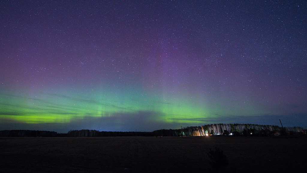
The aurora borealis, also known as the northern lights, could be visible in Pennsylvania Tuesday night.
A geomagnetic storm could reach G2 to G4 levels, which would be a moderate to severe storm.
The best opportunity for viewing in the Susquehanna Valley is 11 p.m. to 5 a.m.
Unfortunately, viewing conditions are expected to be poor with cloudy skies.
Note: the geomagnetic storm “G levels” range from G1 to G5, with G5 being the most extreme.
G1 | MINORG2 | MODERATEG3 | STRONGG4 | SEVEREG5 | EXTREME
What are the northern lights?
The northern lights, or aurora borealis, is a captivating phenomenon characterized by colorful dancing waves of light in the sky. When there is a strong enough geomagnetic storm, the aurora can be seen in Pennsylvania.
During these storms, charged particles collide with gases in the earth’s upper atmosphere, producing the spectacle.
The stronger the geomagnetic storm or larger the amount of material ejected by the sun, the farther south the northern lights can be seen during a storm.
How you can see the northern lightsCheck NOAA’s aurora forecast website. It’s a great resource for potential viewing times.If a northern lights viewing is in the forecast, check the WGAL News 8 Storm Team forecast to see if local conditions are favorable. Just because the Aurora is active, that doesn’t necessarily mean cloud cover and other local conditions won’t interfere with its visibility.If everything lines up for a viewing, you’ll want to maximize the darkness to really enjoy the show. Your best bet is to head to rural areas with very little light pollution. Find a spot, such as a hill or mountaintop, with a clear view of the northern sky and soak it all in.Northern lights forecast
The Space Weather Prediction Center’s website says the Planetary K-index is used to characterize the magnitude of geomagnetic storms. The Kp index goes between 0 and 9.
To see the northern lights in parts of Pennsylvania, a Kp index of at least a seven is needed. At a 7, a faint colored glow low on the horizon, usually in the northern sky, is what we see. The farther north you go, the better your chances of seeing the aurora are.
Read more about the Space Weather Prediction Center here: www.spaceweather.gov.
Share your photos and videos with WGAL
We have several ways you can show us the photos and videos you are capturing.