
Impact Day : Dense, Freezing Fog for the AM Commute in Western PA
LIGHT. ASHLEY. STORY OF THE MORNING. AND THAT IS WHY IT IS AN IMPACT DAY. WE CAN’T EVEN SEE THE CITY. AND IT’S NOT JUST ALLEGHENY COUNTY, IT IS ALL AROUND THE REGION NOW. THIS FOG WILL BURN OFF, SHAPING UP TO BE A NICE AFTERNOON. UPGRADED FRIDAY TO AN IMPACT DAY AS THE TIMING OF THIS RAIN HAS CHANGED MORE FOR THE EVENING COMMUTE THAT’S GOING TO LINGER INTO EARLY SATURDAY BEFORE WE SEE A CLEARING IN A VERY NICE EVENING, ESPECIALLY FOR THE LIGHT UP NIGHT. NOW I WANT TO REALLY IMPORTANTLY SHOW YOU THE ROAD TEMPERATURES, BECAUSE THIS IS GOING TO BE A BIG FACTOR WHERE YOU SEE THE BLUE. THIS IS WHERE OUR ROAD TEMPERATURES ARE, RIGHT NEAR THE FREEZING MARK OF 32 DEGREES. AND THAT IS EXACTLY WHERE WE HAVE OUR FREEZING FOG ADVISORY LAWRENCE MERCER VENANGO CLARION BUTLER ARMSTRONG, INDIANA EXTENDING INTO WESTMORELAND. SO FOG IS A LITTLE BIT OF A MIST. IT’S A CLOUD ON THE GROUND, AND THAT’S WHERE IT COULD FREEZE ON CONTACT. PUTTING A LIGHT GLAZE OF ICE BRIDGES AND OVERPASSES, ESPECIALLY ANY ELEVATED SURFACE, AND MAY EVEN NOTICE IT ON SOME SIDEWALKS AS KIDS ARE HEADING OUT TO THE BUS STOP. SO JUST BE AWARE IN THOSE AREAS NOW, WE DO HAVE A DENSE FOG ADVISORY WITH VERY LOW VISIBILITY INTO ALLEGHENY, BEAVER, WASHINGTON, GREENE, FAYETTE, ALSO INTO CAMBRIA, SOMERSET, DOWN INTO MORGANTOWN. SO AGAIN, THIS FOG IS WHAT’S MAKING AN IMPACT. AND YOU CAN ACTUALLY SEE HOW IT LOOKS LIKE RAIN. BUT THAT’S JUST THE MIST HERE ON OUR CAMERA. AND THIS IS ACTUALLY DROPPED A LITTLE BIT. OUR CAMERA TRYING TO LOOK AT THE PARKWAY EAST THIS MORNING IN WILKINSBURG. STILL THE CITY CAMERA COMPLETELY FOGGED OVER. BUT OVERALL THE NUMBERS DOWN ABOUT 0 TO 2 MILES AROUND A LOT OF THE REGION. THIS WILL SLOWLY BURN OFF UNTIL AROUND 8:00, THOUGH DENSE FOG IS ELEMENTARY AND MIDDLE SCHOOL. KIDS ARE HEADING OUT TO THE BUS STOP. WE’LL START TO SEE SOME IMPROVEMENT AFTER 11:00 THIS MORNING, SO OVERALL, WE’LL GET THROUGH THE FOG. SHAPING UP TO BE A NICE AFTERNOON. IT’S ACTUALLY GOING TO BE A BIT WARMER THAN YESTERDAY INTO THE LOW 50S. IT’S GOING TO BE A NICE DAY TO GET OUTSIDE FRIDAY AGAIN. UPGRADING IT TO AN IMPACT DAY BECAUSE OF THE TIMING OF THE RAIN THAT STILL COULD GO BACK AND FORTH, BUT OVERALL RIGHT NOW DOES LOOK LIKE AS EARLY AS 4:00, OUR AIR TEMPERATURES THIS MORNING, MOST OF US SITTING INTO THE LOW TO MID 30S. SO DEFINITELY A CHILLY START. ONCE WE GET THROUGH THIS FOG, TEMPERATURES WILL WARM UP NICELY INTO THE LOW 50S. SO OVERALL, LET’S TIME OUT THIS RAIN ON FRIDAY. MORNING COMMUTE. NOT MUCH TO WORRY ABOUT. LOOK HOW THIS STARTS TO WORK ITS WAY IN AND PUSHING A LITTLE FURTHER NORTH NOW AROUND 4:00 5:00 WE WILL HAVE SOME POCKETS OF HEAVY RAIN EMBEDDED ALONG INTERSTATE 70 ON SOUTH. THIS INCLUDES WASHINGTON, GREENE, AND FAYETTE COUNTY. RIGHT AROUND 8:00, THIS SWATH OF RAIN MOVES THROUGH, BUT WE’RE STILL GOING TO SEE SOME LINGERING SHOWERS BETWEEN 6:00 AND 12:00 ON SATURDAY. BEFORE THAT CONTINUES TO MOVE OUT OF THE REGION. CLOUDS DECREASE, SETTING US UP FOR A VERY NICE SATURDAY AFTERNOON EVENING, AND THAT’S GOING TO EXTEND INTO SUNDAY. SO WE’LL GET THROUGH OUR IMPACT DAY THIS MORNING. IMPACT DAY AS WE HEAD INTO FRIDAY, ESPECIALLY FOR THE AFTERNOON AND EVENING, BUT FOR LIGHT UP NIGHT ON SATURDAY IF YOU’RE HEADING DOWNTOWN TO ENJOY ALL THE FESTIVITIES, IT WILL BE NICE FOR YOU. CHILLY A FEW CLOUDS DURING THE CITY TREE AND HIGHMARK TREE LIGHT UP BETWEEN 5 AND 7:00, THEN 930. OUR FIREWORKS FINALE IS GOING TO BE COLD BUT DRY. WE WILL STAY DRY FOR MONDAY AND GETTING INTO THANKSGIVING WEEK. LOOKS LIKE SO
Impact Day : Dense, Freezing Fog for the AM Commute in Western PA

Updated: 6:14 AM EST Nov 20, 2025
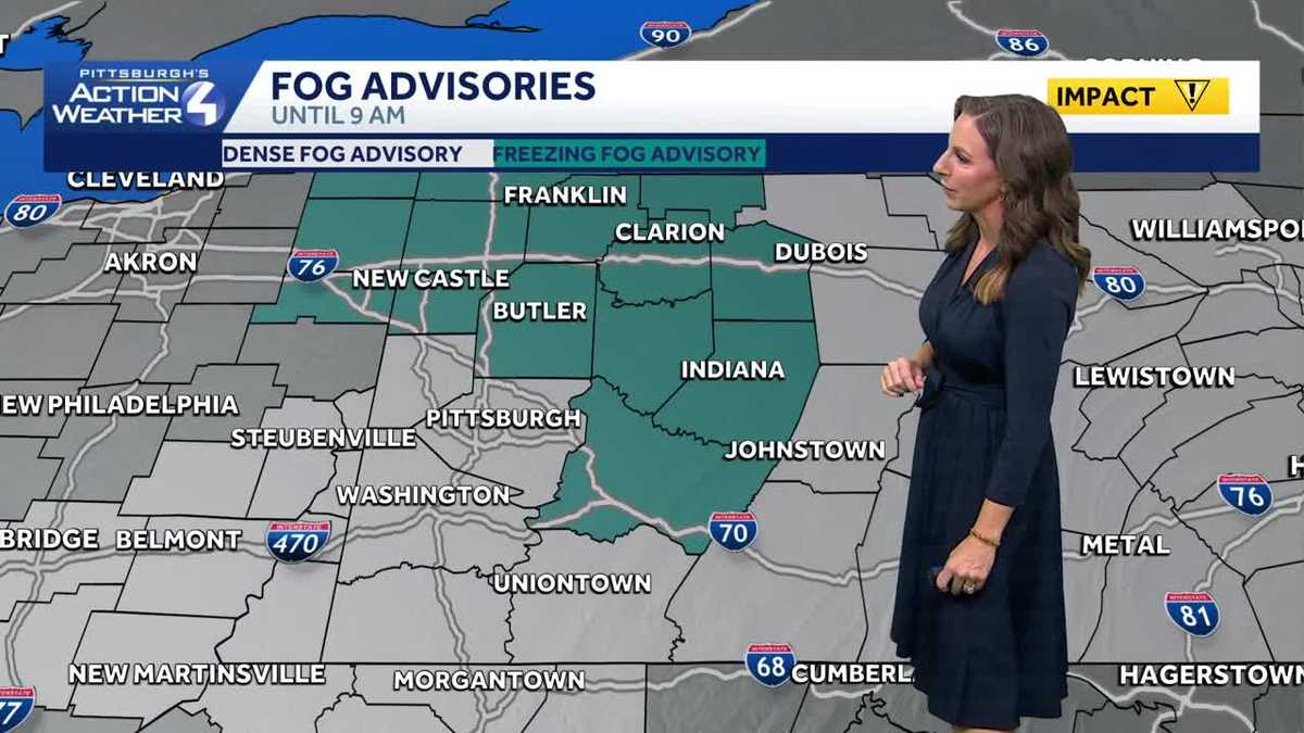
Areas of dense fog this morning makes Thursday morning an Impact Day. Fog will start to lift around 9am.Impact Day: Dense Fog for the AM CommuteDense Fog Advisory and Freezing Fog Advisory in place until 9 am triggering an Impact Day for your morning drive. Visibility will be reduced to a quarter mile or less. A light glaze of ice, especially on bridges and overpasses could make driving conditions hazardous in parts of the region. Drive slowly, use your headlights, and leave plenty of distance ahead of you. Impact Day Friday with PM Rain ShowersThe warmth will also brings rain showers for the Friday evening commute. The scattered rain showers are expected to linger into Saturday morning. We remain dry on Sunday with temperatures climbing into the mid 50s.Mostly dry & mild November weekendShowers look to linger into Saturday morning, but the weekend is shaping up to be a nice one. Showers are expected to exit late Saturday morning with decreasing clouds and some afternoon sunshine. Sunshine sticks around for Sunday too. Temperatures for Light Up Night festivities won’t be too cold. The trend for highs will stay in the low to mid 50s through Wednesday next week. We are watching another round of showers that could slow down pre-holiday travel next Tuesday.TODAY: Impact day with dense AM fog, Clouds return, seasonal. High: 52°TONIGHT: Mostly cloudy. Low 40°FRIDAY: Impact Day. Cloudy skies. evening rain showers. High: 55°, low: 40°.
Areas of dense fog this morning makes Thursday morning an Impact Day. Fog will start to lift around 9am.
Impact Day: Dense Fog for the AM Commute
Dense Fog Advisory and Freezing Fog Advisory in place until 9 am triggering an Impact Day for your morning drive. Visibility will be reduced to a quarter mile or less. A light glaze of ice, especially on bridges and overpasses could make driving conditions hazardous in parts of the region. Drive slowly, use your headlights, and leave plenty of distance ahead of you.

Impact Day Friday with PM Rain Showers
The warmth will also brings rain showers for the Friday evening commute. The scattered rain showers are expected to linger into Saturday morning. We remain dry on Sunday with temperatures climbing into the mid 50s.

Mostly dry & mild November weekend
Showers look to linger into Saturday morning, but the weekend is shaping up to be a nice one. Showers are expected to exit late Saturday morning with decreasing clouds and some afternoon sunshine. Sunshine sticks around for Sunday too. Temperatures for Light Up Night festivities won’t be too cold. The trend for highs will stay in the low to mid 50s through Wednesday next week. We are watching another round of showers that could slow down pre-holiday travel next Tuesday.

TODAY: Impact day with dense AM fog, Clouds return, seasonal. High: 52°
TONIGHT: Mostly cloudy. Low 40°
FRIDAY: Impact Day. Cloudy skies. evening rain showers. High: 55°, low: 40°.