
Rain showers will be rolling through the Pittsburgh area today.
Any Alert Days Ahead? Probably not
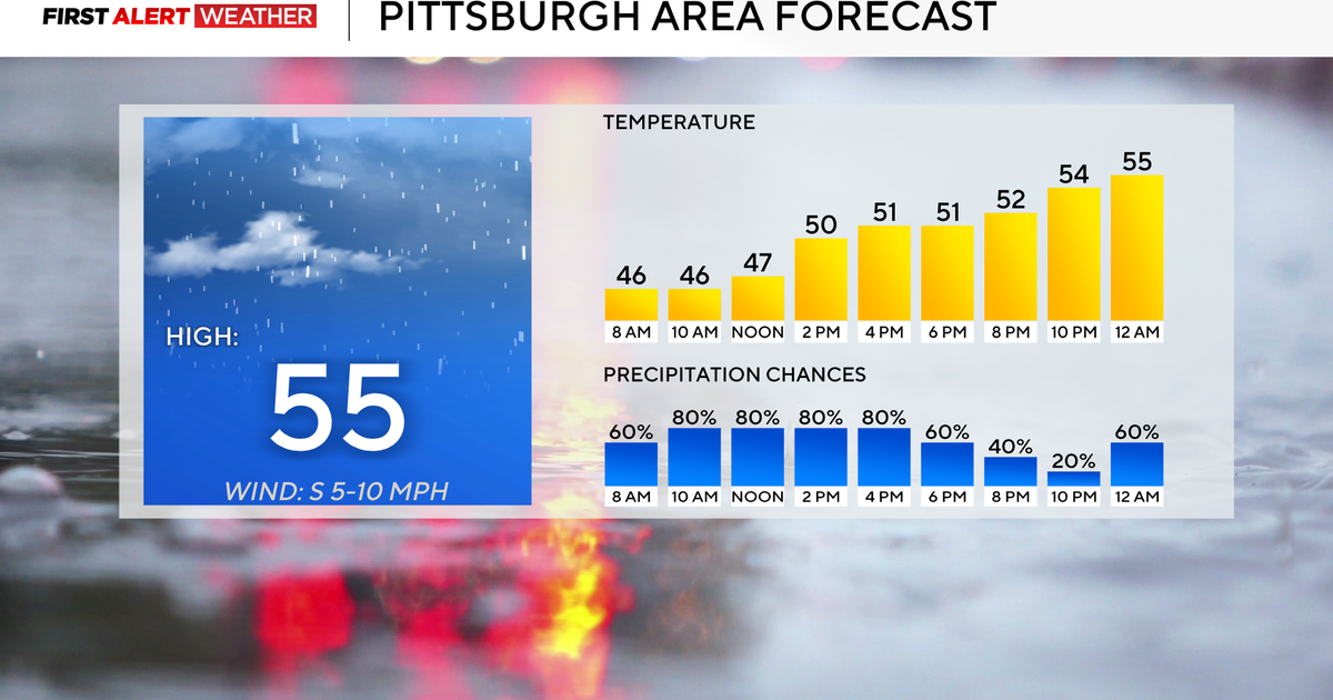
Aware: Today’s high won’t be hit until just before midnight.
Starting today and tomorrow, temperatures will steadily go up today and steadily decrease on Wednesday.
There will be two rounds of rain, including it raining for most of the day today. Wednesday’s rain chance will be lower and confined to the morning. Wednesday afternoon may see some spot snow showers.

KDKA Weather Center
Today’s rain chance will be highest from 8 a.m. to 6 p.m.. Expect light rain showers to have an impact on both the morning and evening commutes.
Rain totals are only expected to be between a quarter of an inch to a half inch. Temperatures will be in the mid to upper 40s this morning, with temperatures in the low 50s this afternoon. Evening to Wednesday morning temperatures will be in the mid-50s before we spend the rest of Wednesday with temperatures ticking down.
The Erie area has a winter storm watch in place for later this week
If you’re traveling for the holiday, the weather overall looks to cooperate, but if you are planning on heading up to the Erie area, there’s a Winter Storm Watch in place from Thursday through Friday evening. This is due to lake effect snow showers. Model data is hinting at maybe a foot of snow for some places with that. My advice is to just make sure you like your in-laws if you are spending the night Thursday into Friday, as you may be stuck at their home for a couple of days afterwards.
Light snow could arrive to the area for Thanksgiving Day and Black Friday
You may see some light snow on Thanksgiving Day and Friday. I do have some concerns that one or two lake effect snow bands will make it across I-80, and those streamers could cause a number of issues as cars drive into rapidly changing conditions. There will also be a snow-to-rain event expected for late Saturday into Sunday morning.

KDKA Weather Center
I don’t expect a lot of rain on Sunday, maybe a quarter of an inch, but if the atmosphere is slightly colder than expected, it could mean some decent snow numbers.
The GFS is showing Sunday’s precipitation coming in as snow.

KDKA Weather Center
Looking way ahead, model data is still continuing to show the chance for rain, snow, and freezing rain on Tuesday and Wednesday of next week. While this is certainly possible, we are still around a week away from it potentially happening. The range in temperatures for freezing rain to happen is so narrow that speculating on what it is likely to mean for us is really a fool’s game at this point. I would just caution that we see it. We know about it. We will have much more on the event, including how it may impact you when our own confidence increases with the setup.
WEATHER LINKS:
Current Conditions | School Closings & Delays | Submit Your Weather Photos