

Even with the multi-colored watch-warn-advisory map, today is really the calm before the storm.
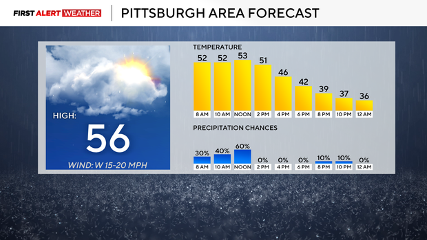
Temperatures will slowly dip, and we will go from the 50s in the morning hours, to the 40s for the afternoon, to eventually dipping into the 30s before midnight.
WEATHER LINKS:
Current Conditions | School Closings & Delays | Submit Your Weather Photos
Most rain showers will end by noon, with the afternoon looking dry. Wind speeds do start to pick up around noon, but they won’t hit criteria levels until around 7 p.m. That is also when the wind advisory kicks in for the Laurel Highlands.
Conditions in the Pittsburgh area – November 26, 2025
KDKA Weather Center
For now, we do not have a First Alert Weather Day in place for Thursday, but one could make a strong argument for one, including us seeing impactful snow happening as far south as I-80, along with strong wind speeds across our coverage area. Winds will be the strongest in the Laurel Highlands and the Ridges, with winds up to 55mph being possible late today into Thursday.
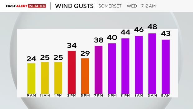
Wind gusts expected in the Somerset area on Wednesday morning
KDKA Weather Center
Snow totals well north of I-80 but south of Erie will likely be near ten inches. I could see anywhere from 2-4 inches of snow falling over or very near I-80 in spots.
It will not impact all of I-80, with any impacts being isolated. Pittsburgh won’t see much snow with only a minor impact occurring on area roads.
Looking ahead, I also have potential First Alert Weather Days on Sunday and Tuesday of next week.

Watches and warnings in our region on November 26, 2025
KDKA Weather Center
Both days will see a similar set-up with us on the northern side of a mid-level low. This will put us in an ideal area to see wrap-around precipitation.
Sunday’s snow chance starts late on Saturday night with snow possibly falling through the morning on Sunday before changing over to rain for the afternoon.
It appears that there will be enough snow at this point to see some collecting on grassy areas. Tuesday’s snow is for now, timed to happen in the middle of the day. A high temperature on Tuesday in the mid-30s means that, similar to Sunday, we will not see too much of an impact from snow.

7-day forecast: November 26, 2025
KDKA Weather Center
Stay up to date with the KDKA Mobile App – which you can download here!