
SYSTEM THAT GETS HERE ON SUNDAY. UNTIL THAT POINT THOUGH, WE’LL SEE CLOUDS INCREASE TOMORROW. WATCHING FOR AN EARLY MORNING SHOWER CHANCE ON SATURDAY. SUNDAY IS THE BLEMISH OF THE WEEK THOUGH. THAT IS OUR IMPACT DAY, WHERE WINDS WILL ALSO GUSTS POTENTIALLY UP TO 35MPH. AND THAT’S EVEN OUTSIDE OF RAIN SHOWERS ACROSS THE AREA. TONIGHT, THOUGH, WE FIRST HAVE TO GET THROUGH A FREEZE WARNING. THAT’S EVERYBODY IN PURPLE, WHICH IS BASICALLY EAST AND NORTH OF ALLEGHENY COUNTY. ALLEGHENY COUNTY AND POINTS WEST BASICALLY ALONG I-79. YOU’RE UNDER FROST ADVISORY. THE TAKEAWAY IS GOING TO BE COLD TONIGHT FOR SOME OF US. EVERYBODY IN THE SHADE OF PURPLE COULD BE THE FIRST TIME THIS SEASON YOU DROP TO FREEZING IF YOU HAVEN’T ALREADY. SO IF YOUR PLANTS HAVE SURVIVED THE LAST COUPLE OF NIGHTS, YOU MAY WANT TO MAKE SURE THEY’RE SAFE THOUGH. TONIGHT AGAIN, THIS WILL BE THE COLDEST ONE OF THIS STRETCH, 63 DEGREES FOR US TOMORROW. 74 ON SATURDAY, 72 ON SUNDAY. AGAIN, THAT IS OUR IMPACT DAY. WE’LL BE WATCHING. THOSE RAIN SHOWERS WILL LINGER INTO MONDAY AT 61. MORE SHOWER CHANCE ON TUESDAY THEN OUR TEMPERATURES DROP. LOOK AT LATE NEXT WEEK. WE’RE IN THE MIDDLE 50S FOR HIGH TEMPERATURES WITH LOWS IN THE LOWER 40S. THAT IS MORE OF A NOVEMBER FEEL, WHICH OF COURSE NOVEMBER IS NOT THAT FAR AWAY, BUT IT STILL OCTOBER. KIND OF AN EARLY PREVIEW. SO TOMORROW MORNING HERE’S OUR FUTURECAST PAINTING TEMPERATURES AGAIN OUTSIDE OF ALLEGHENY COUNTY. ALMOST EVERYBODY HAS THE CHANCE TO POTENTIALLY START AT FREEZING TOMORROW MORNING. THEN WE WILL CLIMB BACK INTO THE LOWER 60S, WILL BE INTO THE 50S BY LUNCHTIME AND EXPECT HIGH TEMPERATURES TOMORROW, JUST LIKE TODAY, TO CLIMB INTO THE LOWER 60S. THERE’S A STRAY EARLY MORNING SHOWER CHANCE ON SATURDAY. THE BEST CHANCE OF THAT IS NORTH OF THE CITY. BY THE TIME MOST OF US WAKE UP, THOUGH, THE RAIN IS GONE. CLOUDS STAY WITH US THROUGH THE DAY. IF YOU’RE MAKING SUNDAY MORNING PLANS, YOU SHOULD BE ABLE TO GET OUTSIDE FINE. AFTER ABOUT LUNCHTIME, THOUGH, RAIN ARRIVES FROM THE WEST AND AGAIN WINDS WILL PICK UP AS WE HEAD THROUGH THE DAY AND THIS COULD BE A PRETTY GOOD RAINMAKER FOR US. WE’RE TALKING, ON AVERAGE, ABOUT A HALF AN INCH TO AN INCH OF RAIN ACROSS WESTERN PENNSYLVANIA, WITH POTENTIALLY SOME LOCALLY HIGHER AMOUNTS. SHE’LL BE OKAY, THOUGH, FOR A GAME OF THE WEEK. FRIDAY NIGHT TEMPERATURES WILL BE IN THE 50S FOR GAMES AREA WIDE IF YOU’RE HEADING OUT. IF YOU’RE HEADING OUT THIS EVENING, SKIES ARE CLEAR ON ACTION CAM 61 WITH A STRONG NORTH WIND AT 12MPH. TEMPERATURES FALL QUICKLY
Pittsburgh: Another cold morning, Impact Day Sunday
Frosty conditions are again possible Friday morning.

Updated: 4:28 PM EDT Oct 16, 2025
Clear skies and light winds again Friday morning will allow for another frosty start. Temperatures warm into the weekend as rain showers return. Another Cold Start FridayA Freeze Warning has been issued for Armstrong, Butler, Clarion, Fayette, Forest, Garrett, Indiana, Preston (highlands), Westmoreland, and Venango counties from 2 a.m. to 9 a.m.A Frost Advisory has been issued for Allegheny, Beaver, Greene, Lawrence, Monongalia, Preston (lowlands), and Washington counties from 2 a.m. to 9 a.m.Weekend showers prompt Impact DayOur next system may spark a few showers early Saturday morning, but those will end before most of us wake up. Temperatures warm into the 70s on Saturday.Our next cold front arrives on Sunday morning. Before it even arrives, it will be windy with gusts over 35 mph possible across the area. These strong winds will keep our temperatures up through the night. Rain looks to arrive in the late morning with the most widespread and heaviest rain falling after lunch.By the time rain ends Monday, rainfall totals between one half and one inch of rain are likely with locally higher amounts. A shower chance returns on Tuesday with below normal temperatures and clouds through late next week.TONIGHT: Clear and cold, Freeze Watch. Low 38°FRIDAY: Patchy morning frost, mostly sunny. High 62°SATURDAY: Early morning showers then mostly cloudy. High 73°. Low: 47°
PITTSBURGH —
Clear skies and light winds again Friday morning will allow for another frosty start. Temperatures warm into the weekend as rain showers return.
Another Cold Start Friday
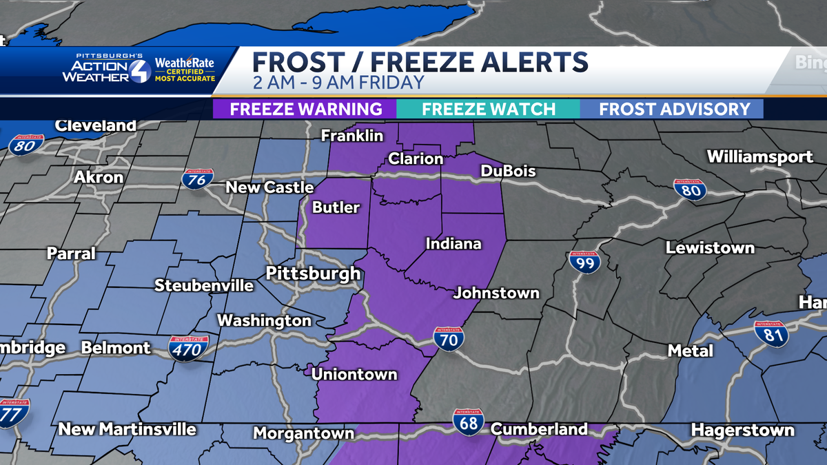
A Freeze Warning has been issued for Armstrong, Butler, Clarion, Fayette, Forest, Garrett, Indiana, Preston (highlands), Westmoreland, and Venango counties from 2 a.m. to 9 a.m.
A Frost Advisory has been issued for Allegheny, Beaver, Greene, Lawrence, Monongalia, Preston (lowlands), and Washington counties from 2 a.m. to 9 a.m.

Hearst Owned
Frost Advisory and Freeze Warning out for Western PA for Friday morning.
Weekend showers prompt Impact Day

Hearst Owned
Rain showers, with heavy downpours, will be prevalent the second half of Sunday.
Our next system may spark a few showers early Saturday morning, but those will end before most of us wake up. Temperatures warm into the 70s on Saturday.

Hearst Owned
Wind gusts could exceed 35 mph through the day Sunday.
Our next cold front arrives on Sunday morning. Before it even arrives, it will be windy with gusts over 35 mph possible across the area. These strong winds will keep our temperatures up through the night. Rain looks to arrive in the late morning with the most widespread and heaviest rain falling after lunch.
By the time rain ends Monday, rainfall totals between one half and one inch of rain are likely with locally higher amounts. A shower chance returns on Tuesday with below normal temperatures and clouds through late next week.

Hearst Owned
A soggy end to the weekend and much colder next week.
TONIGHT: Clear and cold, Freeze Watch. Low 38°
FRIDAY: Patchy morning frost, mostly sunny. High 62°
SATURDAY: Early morning showers then mostly cloudy. High 73°. Low: 47°