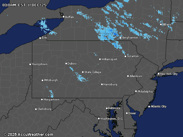
A widespread snowfall will impact central Pennsylvania Monday night into Tuesday, with accumulations of 4-5 inches expected across much of the region. The National Weather Service has issued winter weather advisories and watches as the first significant snow event of the season approaches.
Snow will begin shortly after midnight in northwestern mountains before spreading across the region. The heaviest accumulations will occur during a six-hour window, potentially impacting Tuesday morning commutes with snowfall rates approaching 1 inch per hour in some locations. Areas in northeastern Pennsylvania, including Sullivan, Columbia and Schuylkill counties, are under a Winter Storm Watch with potential for 6 or more inches of snow.
Most of central Pennsylvania can expect 4-5 inches, though areas southeast of U.S. 30 in York and Lancaster counties may see a mix of snow, sleet and freezing rain. The precipitation is expected to taper off late Tuesday afternoon.
Following Tuesday’s storm, high pressure will build in Wednesday before another cold front moves through Wednesday night into Thursday. This Arctic front will likely produce snow showers or squalls, particularly along the I-99/U.S. 15 corridor by midday Thursday.
Significantly colder air will arrive Thursday night and Friday, with lows dropping into the single digits and teens while highs struggle to reach the 20s to low 30s. This marks the coldest temperatures of the season so far.
The long-range forecast indicates a prolonged period of below-normal temperatures and an active storm track through the first week of December, with another potential storm system affecting the region by next weekend.
Current weather radar