
Increasing clouds this evening & weak system brings light snow mix to rain Sunday in south-central Pennsylvania
High pressure provides lighter winds and bright skies today. It will remain colder than average. Sunday’s system is weak and doesn’t bring much. We’re keeping a close eye on the potential for a significant winter storm on Tuesday.
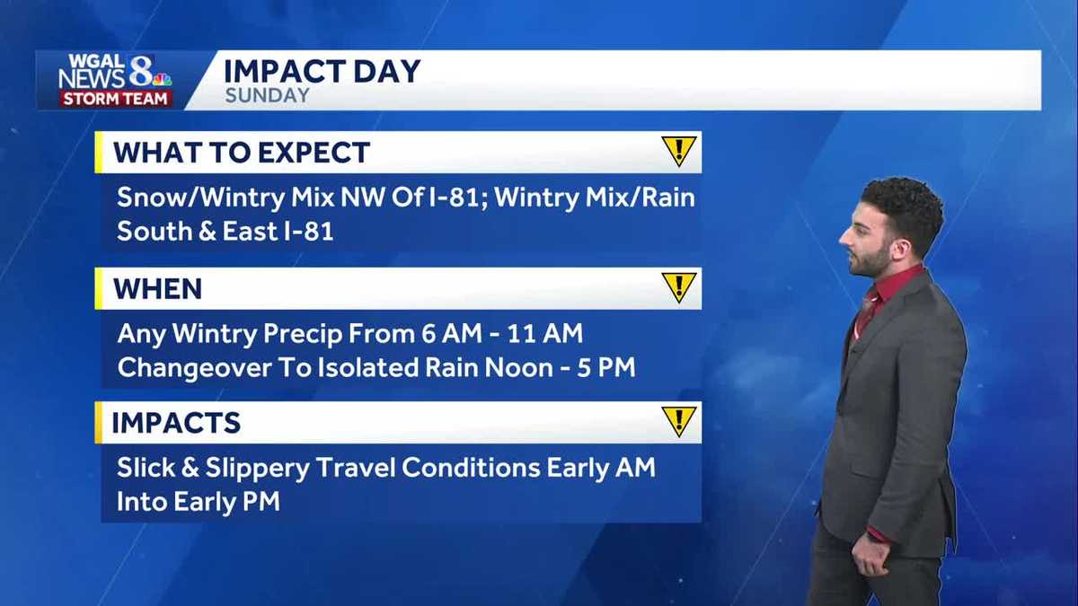
NATIONWIDE AT ALDI. WELL, RYAN, A PRETTY CLEAR START TO OUR WEEKEND, BUT IT SOUNDS LIKE SNOW MIGHT BE ON THE WAY. YEAH, SO WE ARE LOOKING AT NOT ONLY A WINTRY MIX OF SOME RAIN AND SNOW, BUT WE’RE ALSO LOOKING AT OUR NEXT CHANCE OF A WINTER STORM THAT COULD BE COMING IN FOR OUR TUESDAY. BUT BEFORE WE GET TO TUESDAY, LET’S START FOR SUNDAY. EARLY LIGHT MIX, THEN TRANSITIONING TO AN AFTERNOON EVENING RAIN SHOWERS FOR YOUR SUNDAY. BUT WE MADE IT AN IMPACT DAY BECAUSE IT’S JUST AFTER A BIG HOLIDAY WEEK FOR THANKSGIVING TRAVEL. SO IF YOU’RE COMING HOME FROM FAMILY, ESPECIALLY, ESPECIALLY IN THE MORNING TIME FOR YOUR SUNDAY, YOU MIGHT RUN INTO SOME SLIPPERY ROAD CONDITIONS. SO YOU JUST WANT TO MAKE SURE YOU TAKE EXTRA PRECAUTION ON THE ROADS. AS WE GET INTO THE SECOND HALF OF THE WEEKEND, BRISK AND COLD START TO THE WORKWEEK, BUT THEN ONCE WE GET TO TUESDAY, WE’RE TRACKING THIS NEXT POTENTIAL WINTER STORM. WE’VE ALSO RATED THAT AS AN IMPACT DAY. WE’LL CHAT MORE ABOUT THAT HERE IN JUST A FEW MORE MINUTES. ALMANAC FOR THE DAY TODAY. HIT 40 AT HARRISBURG INTERNATIONAL, USUALLY EXPECTING 49 FOR THIS TIME OF YEAR. SO WE’RE ALMOST TEN DEGREES BELOW AVERAGE FOR THIS TIME OF YEAR. 28 WAS EARLIER THIS MORNING’S LOW HIT. 32 IS WHAT WE EXPECT FOR THIS TIME OF YEAR. NO RAINFALL RECORDED AT HARRISBURG INTERNATIONAL AIRPORT, SO WE’LL CONTINUE TO SEE INCREASING CLOUD COVER. STILL CHILLY DOWN INTO THE 30S AND MOSTLY CLOUDY. BRISK AND COLD DOWN INTO THE LOW 30S AS WELL AS YOU CAN SEE HERE. AND THEN AS WE GET INTO TOMORROW AFTERNOON, THAT’S WHEN WE’VE OR TOMORROW MORNING INTO THE AFTERNOON, I SHOULD SAY GOING TO START WITH THAT MORNING SNOW, RAIN MIX AND THEN GOING OVER OR TRANSITION TRANSITIONING TO RAIN. ONCE WE GET INTO THE AFTERNOON AND INTO THE EVENING AGAIN, WE LEFT THAT AS AN IMPACT PERIOD BECAUSE OF THE TRAVEL CONDITIONS THAT MAY BE, MAY, MAY BEGIN TO GO DOWN. NOW IN TERMS OF CHRISTMAS SPIRIT LIGHT SHOW FOR FOR TONIGHT AGAIN, THAT’S FROM 530 TO 10:00. TONIGHT WE’RE GOING TO CONTINUE TO SEE INCREASING CLOUDS STILL FEELING BRISK OUT THERE AND REMAINING CLOUDY AS WE END THE EVENING. WE’RE GETTING INTO TONIGHT. TEMPERATURES INTO THE 30S. YOU CAN SEE 26 IN THE WHITE ROSE CITY, 33 IN CARLISLE, 34 IN LEWISTOWN. AT THIS TIME, WINDS ARE CALM RIGHT NOW, BUT WE’RE GOING TO START TO SEE THOSE WINDS BEGIN TO INCREASE AS WE GET INTO THE AFTERNOON. AS THIS NEXT SYSTEM STARTS TO PUSH THROUGH. SO LET ME SHOW YOU WHERE WE’RE AT NOW. STORM TEAM LIVE RADAR NETWORK. ALL CLEAR. THANKS TO SOME BRIEF HIGH PRESSURE THAT’S BUILT INTO THE AREA. BUT AS WE START TO SEE THE OUTER FRINGES OF THIS STORM SYSTEM BEGIN TO MOVE THROUGH, THEN THAT’S WHEN WE’RE GOING TO START TO SEE, YOU KNOW, WE’RE GOING TO SEE OVERCAST CONDITIONS AND ALSO THE CHANCE FOR SOME SNOW TO BEGIN TO BEGIN TO COME THROUGH RIGHT AROUND 6:00 IN THE MORNING. YOU CAN SEE SOME OF THOSE OUTER BANDS, BUT I WILL MAKE A MENTION OF THIS BECAUSE WE HAVE HIGH PRESSURE IN THE AREA. IT’S ALLOWING FOR MORE DRY AIR. AND SO AS THIS MOISTURE RUNS INTO RUNS INTO THAT DRY AIR, IT’S GOING TO START TO DISSIPATE A LITTLE BIT. SO WE’RE GOING TO BE REALLY SEEING ISOLATED SNOW FLURRIES OR LIGHT SNOW, ESPECIALLY FOR AREAS THAT ARE NORTHWEST OF I-81. JUST AS A DELINEATION HERE, SEE SOME OF THOSE ISOLATED SHOWERS THEN BEGINNING TO TURN TO A MIX AS WE GET INTO LATER IN THE MORNING AND CLOSER TO THE AFTERNOON. THERE’S THAT MIXED LINE THERE, AND ALSO THE CHANCE FOR SOME ISOLATED SHOWERS ONCE WE GET TO THE AFTERNOON. YOU CAN SEE THAT CHANCE THERE FOR SUNDAY AND THEN ALSO FOR SUNDAY EVENING. NOW COLD FRONT STARTS TO COME THROUGH. THEN WE’RE GOING TO START TO SEE SOME HIGH PRESSURE BUILDING INTO THE AREA, ALLOWING FOR ANOTHER BRIEF SHOT OF SOME CLEAR SKIES AND PARTLY TO MOSTLY SUNNY CONDITIONS. BUT THEN, LOOKING AHEAD, GETTING INTO TUESDAY, THAT’S WHAT’S GOING TO BE OUR NEXT TALKER. SO HERE’S DETAILS FOR YOUR SUNDAY. FIRST, BEFORE WE GET TO TUESDAY. SNOW AND A WINTRY MIX NORTHWEST OF I-81 AND A WINTRY MIX TO RAIN SOUTH AND EAST OF I-81. SO KEEP THIS IN MIND AND WHAT TO EXPECT WHEN 6 A.M. TO 11 A.M. FOR ANY WINTRY PRECIPITATION, THEN CHANGING OVER TO ISOLATED RAIN FROM NOON TO FIVE WITH THOSE SLICK AND SLIPPERY TRAVEL CONDITIONS. NOW HERE’S TUESDAY STEPPING HERE JUST A SECOND. WE DO HAVE RAIN. WE HAVE TUESDAY RATED AS A HIGH CHANCE OF SEEING PRECIPITATION FROM TUESDAY MORNING UNTIL TUESDAY EVENING. FOR SNOW TO RAIN FOR MOST FOR MOST OF THE AREA, BUT THE HIGHEST SNOW CHANCES BEING NORTH AND WEST OF I-81, SO WE COULD BE RUNNING INTO A SLOW MORNING COMMUTE FOR YOUR TUESDAY. SO SNOW DEVELOPING TUESDAY MORNING, CHANGING TO RAIN FOR SOME FOR TUESDAY AFTERNOON WITH MINOR ACCUMULATIONS BEFORE THE CHANGEOVER, AND THOSE LOWER TOTALS BEING TOWARDS THE SOUTHEAST. SO THAT’S WHAT WE KNOW SO FAR FOR YOUR TUESDAY. SO WE’VE RATED TUESDAY AS AN IMPACT DAY. LOOKING AHEAD INTO WEDNESDAY AND THURSDAY OF NEXT WEEK LOOKING PARTLY SUNNY AND ALSO COLD AND LOOKING AT SOME MOR
Increasing clouds this evening & weak system brings light snow mix to rain Sunday in south-central Pennsylvania
High pressure provides lighter winds and bright skies today. It will remain colder than average. Sunday’s system is weak and doesn’t bring much. We’re keeping a close eye on the potential for a significant winter storm on Tuesday.

Updated: 6:29 PM EST Nov 29, 2025
High pressure building in has provided mostly sunny skies this afternoon into the evening. Temperatures will begin to drop towards the lower 30s this evening and cloud cover will begin to move in across the Valley for tonight.Tonight, with our next system closing in from the west, we’ll see mostly cloudy skies with lows dropping to 30 degrees. Winds will begin to pick up and shift from the west, and come from the southeast between 5-10 mph.IMPACT DAY SUNDAY:Precipitation chances return Sunday morning, as low pressure lifts into the Great Lakes. There is a brief chance for a wintry mix early before switching to rain. However, higher elevations may continue to see a snow mix a little longer.Please use caution when traveling early Sunday, as there may be some slick spots, especially at higher elevations. Minor accumulation is possible at higher elevations. Highs will be near 40 degrees in the afternoon, and light rain showers will end early afternoon. It will be breezy out of the south-southwest 10 to 15 mph.It’s a quiet, cold start to the work week. Highs are once again around 40°. It will be a little breezy with northwesterly winds around 10 to 15 mph.The News 8 Storm Team is tracking the potential for a winter storm Tuesday.It is becoming more likely that a winter storm will move across the Mid-Atlantic. We have made it an Impact Day. Depending on the track of the system, this would be the first accumulating snow of the season. Part of the area will see mainly snow while other areas may see a mix or even plain rain. The track of the storm will determine where the rain/snow line sets up and where accumulating snow occurs. It is still too early for snow totals as models continue to be very changeable, but plowable snow is a possibility for some. Stay tuned for updates this weekend.All of next week will feature the continuation of below-average temperatures for early December. Highs will hover near 40 ° most days, with lows in the upper 20s to low 30s.Next chance for rain or snow is Saturday.Have a great rest of your Saturday!~ Ryan
High pressure building in has provided mostly sunny skies this afternoon into the evening. Temperatures will begin to drop towards the lower 30s this evening and cloud cover will begin to move in across the Valley for tonight.
Tonight, with our next system closing in from the west, we’ll see mostly cloudy skies with lows dropping to 30 degrees. Winds will begin to pick up and shift from the west, and come from the southeast between 5-10 mph.
IMPACT DAY SUNDAY:
Precipitation chances return Sunday morning, as low pressure lifts into the Great Lakes. There is a brief chance for a wintry mix early before switching to rain. However, higher elevations may continue to see a snow mix a little longer.
Please use caution when traveling early Sunday, as there may be some slick spots, especially at higher elevations. Minor accumulation is possible at higher elevations. Highs will be near 40 degrees in the afternoon, and light rain showers will end early afternoon. It will be breezy out of the south-southwest 10 to 15 mph.
It’s a quiet, cold start to the work week. Highs are once again around 40°. It will be a little breezy with northwesterly winds around 10 to 15 mph.
The News 8 Storm Team is tracking the potential for a winter storm Tuesday.
It is becoming more likely that a winter storm will move across the Mid-Atlantic. We have made it an Impact Day. Depending on the track of the system, this would be the first accumulating snow of the season. Part of the area will see mainly snow while other areas may see a mix or even plain rain. The track of the storm will determine where the rain/snow line sets up and where accumulating snow occurs. It is still too early for snow totals as models continue to be very changeable, but plowable snow is a possibility for some. Stay tuned for updates this weekend.
All of next week will feature the continuation of below-average temperatures for early December. Highs will hover near 40 ° most days, with lows in the upper 20s to low 30s.
Next chance for rain or snow is Saturday.
Have a great rest of your Saturday!
~ Ryan