
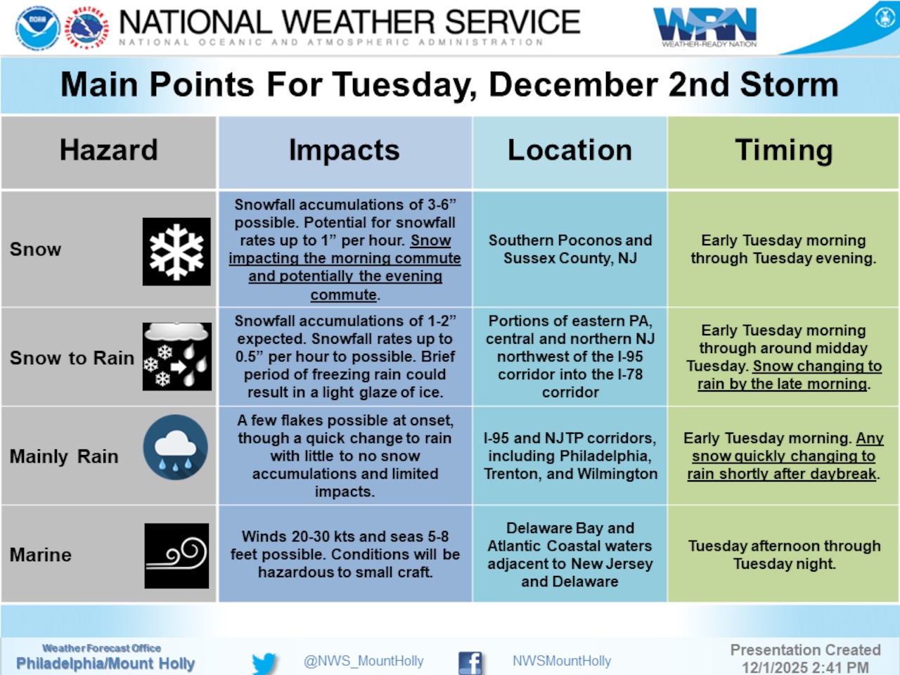
The National Weather Service on Monday afternoon cut its forecast for snowfall accumulations Tuesday but still warned of potentially hazardous driving conditions.
The winter storm is expected to impact the Lehigh Valley and Poconos, bringing a mix of snow and rain that could create challenging travel conditions during the morning commute.
The National Weather Service has issued a Winter Weather Advisory for the region, with snowfall expected primarily in areas along and north of Interstate 78.
The storm is forecast to arrive Tuesday morning, with precipitation beginning between 7 and 10 a.m. Areas in the Poconos and northwestern New Jersey are most likely to see snowfall, with accumulations ranging from 1 to 3 inches along the I-78 corridor. That’s down from a potential 2 to 5 inches of accumulation forecast earlier Monday.
Higher elevations above 1,500 feet may see 3 to 6 inches of snow, particularly in the Pocono Plateau and higher elevations of northwestern New Jersey.
Temperatures will play a crucial role in the precipitation type, with morning temperatures hovering near freezing. The Poconos and areas northwest of I-78 are expected to start with snow, while the I-95 corridor and areas south and east are likely to experience primarily rain. By Tuesday afternoon, most areas are expected to transition to rain, with high temperatures ranging from mid-30s in the Poconos to low 50s along coastal areas.
Residents should be prepared for potentially hazardous morning commute conditions, especially in northern areas. The National Weather Service recommends allowing extra time for travel, maintaining reduced speeds, and being prepared for quickly changing road conditions. By Tuesday afternoon, most snow is expected to melt as temperatures rise and precipitation changes to rain.
Pennsylvania transportation officials on Monday announced vehicle restrictions and lower speed limits on highways in and around the Lehigh Valley region.
The extended forecast indicates continued cold temperatures for the remainder of the week, with highs remaining below average. Wednesday will be partly clear with highs in the mid-30s to low 40s, and Thursday will bring a cold front that could produce isolated snow showers in the Poconos.
Temperatures are expected to drop significantly Thursday night, with lows potentially reaching single digits in the Poconos and teens across eastern Pennsylvania.
Current weather radar
Generative AI was used to produce an initial draft of this story, which was reviewed and edited by lehighvalleylive.com staff.