
A storm will bring accumulating snow to the Pittsburgh region on Tuesday. A winter weather advisory has been issued throughout western Pennsylvania.Tuesday is an Impact Day for accumulating snow that will be falling and sticking during the morning commute.Winter weather alerts: Read the alert for your countyInteractive radar: Track the snow as it moves through your neighborhoodSevere weather alerts: Sign up to get FREE weather alerts delivered to your phone or emailWinter Weather Advisory for western PennsylvaniaSnow showers develop after midnight and will continue through 9 a.m. A Winter Weather Advisory is in effect between midnight and 1 p.m., Tuesday, for the entire area. The timing and amounts prompt the Impact Day. Western PA will wake up to snow on the ground with additional accumulations through the morning commute.The snow will taper off by noon. The evening drive should run more smoothly.This will be the first accumulating snow for Pittsburgh. Amounts will be fairly unifor,m with 2″ to 4″. The majority of the snow will fall between 4 a.m. and 9 a.m. Locally higher amounts are possible near and north of I-80. A brief period of freezing rain or sleet could “eat up” some of the snow totals near the PA-WV border.When will the snow fall?Snow looks to begin arriving across western Pennsylvania between 1 a.m. and 3 a.m.The heaviest amounts of snow should fall between 4 a.m. and 9 a.m.Snow will taper off after 10 a.m., with flurries to light lake-effect snow lingering through Tuesday afternoon.Hour-by-hour snow projections: See when the snow will fallHow much snow will we get?Snow totals of 2-4 inches are possible areawide, with an isolated higher amount possible in the Laurel Highlands.If some warm air comes farther north than currently anticipated, the Laurel Highlands could see a brief period of sleet or freezing rain. That looks unlikely at this point.More snow on Thursday, colder temperaturesHigh temperatures will be in the 30s for the first week of December. Sunshine will peak back on Wednesday. A weak clipper races through the area on Thursday with more flurries, but no accumulation. It will also be a breezy day. The coldest morning of the season so far will be Friday with temperatures in the teens. We are watching another system heading into the weekend. MONDAY: Mostly cloudy. High 35.MONDAY NIGHT: Impact Day. Snow arrives. Low 38.TUESDAY: Impact Day. Snow until lunch, then flurries to a light snow shower. High 34.WEDNESDAY: Mostly cloudy. High 33, low 22.
PITTSBURGH —
A storm will bring accumulating snow to the Pittsburgh region on Tuesday. A winter weather advisory has been issued throughout western Pennsylvania.
Tuesday is an Impact Day for accumulating snow that will be falling and sticking during the morning commute.
Winter weather alerts: Read the alert for your county
Interactive radar: Track the snow as it moves through your neighborhood
Severe weather alerts: Sign up to get FREE weather alerts delivered to your phone or email
Winter Weather Advisory for western Pennsylvania
Snow showers develop after midnight and will continue through 9 a.m.
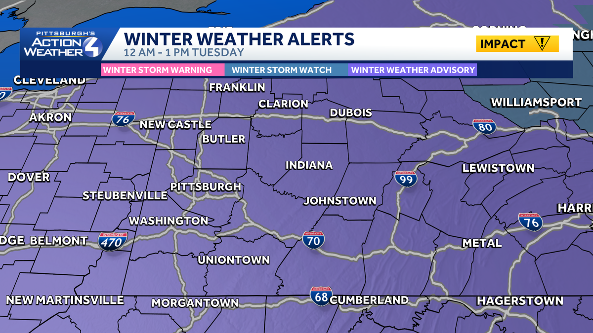
A Winter Weather Advisory is in effect between midnight and 1 p.m., Tuesday, for the entire area. The timing and amounts prompt the Impact Day.
Western PA will wake up to snow on the ground with additional accumulations through the morning commute.
The snow will taper off by noon. The evening drive should run more smoothly.

Hearst OwnedHearst
A Winter Weather Advisory during the first half of Tuesday.
This will be the first accumulating snow for Pittsburgh.
Amounts will be fairly unifor,m with 2″ to 4″. The majority of the snow will fall between 4 a.m. and 9 a.m. Locally higher amounts are possible near and north of I-80.
A brief period of freezing rain or sleet could “eat up” some of the snow totals near the PA-WV border.
When will the snow fall?
Snow looks to begin arriving across western Pennsylvania between 1 a.m. and 3 a.m.
The heaviest amounts of snow should fall between 4 a.m. and 9 a.m.
Snow will taper off after 10 a.m., with flurries to light lake-effect snow lingering through Tuesday afternoon.
Hour-by-hour snow projections: See when the snow will fall
How much snow will we get?
Snow totals of 2-4 inches are possible areawide, with an isolated higher amount possible in the Laurel Highlands.
If some warm air comes farther north than currently anticipated, the Laurel Highlands could see a brief period of sleet or freezing rain. That looks unlikely at this point.

Hearst OwnedHearst
This will be an efficient snow storm. Most of the accumulation occurs between 4 a.m. and 10 a.m. Tuesday.
More snow on Thursday, colder temperatures
High temperatures will be in the 30s for the first week of December.
Sunshine will peak back on Wednesday.
A weak clipper races through the area on Thursday with more flurries, but no accumulation. It will also be a breezy day.
The coldest morning of the season so far will be Friday with temperatures in the teens. We are watching another system heading into the weekend.
MONDAY: Mostly cloudy. High 35.
MONDAY NIGHT: Impact Day. Snow arrives. Low 38.
TUESDAY: Impact Day. Snow until lunch, then flurries to a light snow shower. High 34.
WEDNESDAY: Mostly cloudy. High 33, low 22.