
Increasing sunshine today, then an Arctic front Thursday leading to a frigid Friday across south-central Pennsylvania
Unseasonably cold conditions will persist well into next week. We’re also tracking an Arctic boundary that will come through Thursday, allowing frigid air to settle in Friday. We’ll come close to record lows.
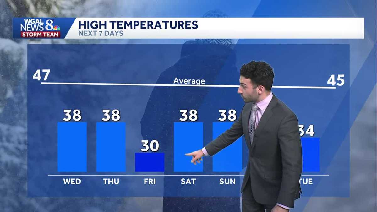
AWAY FROM PORCH PIRATES. PLENTY OF SUNSHINE FOR THE DAY TODAY. STILL QUITE COLD THOUGH. WE’RE INTO THE 30S FOR MOST OF THE AREA, BUT WE ARE. IT’S GOING TO BE FEELING COLDER. IT’S GOING TO BE GETTING COLDER AS WE GET INTO NOT ONLY THE END OF THURSDAY, BUT ALSO IN THE FRIDAY WE’RE GOING TO BE. IT’S GOING TO BE FEELING FRIGID FOR THE LAST DAY OF THE WORKWEEK. NEAR RECORD LOW TEMPERATURES WILL HAVE RECORD CHALLENGING TEMPERATURES AS WE GET INTO OUR FRIDAY FORECAST FOR THE DAY TODAY. EXPECT SUN AND SOME CLOUDS. IT WILL BE COLD OUT THERE 36 TO 40 DEGREES WITH LIGHTER WINDS, INCREASING CLOUDS LATE. BUT JUST BE ON THE LOOKOUT FOR ANY ANY PATCHY BLACK ICE THAT MIGHT BE REMAINING. ANY OF THE SNOW THAT MELTS TODAY THAT COULD GET ONTO THE ROADWAYS, THAT MIGHT FREEZE OVER. SO JUST BE ALERT ON FOR SOME ANY, ANY TYPE OF PATCHY BLACK ICE THAT MIGHT, THAT MIGHT, THAT MIGHT DEVELOP 24 TO 28 DEGREES FOR OVERNIGHT TONIGHT, THEN FOR TOMORROW, LOOKING AT SOME MORNING CLOUDS, THEN GETTING INTO THE AFTERNOON WE’LL SEE SOME SUNSHINE, BLUSTERY AND COLD. COULD SEE A FEW FLURRIES AS WE GET INTO THE DAY. 36 TO 40 DEGREES. SO LEWISTOWN CHRISTMAS PARADE THAT WILL BE THIS EVENING. 6:00 IS WHEN THAT WILL BE STARTING. LIGHT WINDS MOSTLY CLEAR AND BUT EVENTUALLY, ONCE WE GET INTO TONIGHT, THAT’S WHEN WE’LL START TO SEE THE INCREASE IN THE CLOUD COVER. BUT YOU CAN YOU CAN EXPECT MOSTLY CLEAR CONDITIONS FOR FOR THE EVENT FOR TODAY. SO LET’S TALK ABOUT THE TEMPERATURES. THE BIG THE BIG TALKER AS WE GET INTO THIS WEEK IS THIS ARCTIC FRONT THAT’S GOING TO START TO MOVE THROUGH AS WE GET INTO THURSDAY. YOU CAN SEE TEMPERATURES INTO THE 30S FOR THE MAJORITY OF THE AREA, 38 IN THE RED ROSE CITY. BUT YOU CAN SEE ACROSS THE COUNTRY, YOU CAN SEE WE’RE DOWN INTO THE 20S TOWARDS LOUISVILLE, 31 IN NASHVILLE, 32 IN MEMPHIS, 50 DEGREES NOW IN DALLAS. BUT LOOK WHAT’S TO COME LATER. LOOK AT THIS. GETTING INTO THE TEENS. NOW WE ARE EXPECTING TO SEE THIS, THIS AIR MASS BEGIN TO MOVE IN CLOSER TO THE AREA. AND THAT’S WHAT’S GOING TO HELP TO PROMOTE TEMPERATURES GETTING DOWN TO 30 DEGREES FOR OUR FRIDAY. THIS IS WHAT WE’RE FORECASTING AS WE GET INTO THE AFTERNOON. AND NOTICE THAT THE AVERAGE FOR THIS TIME OF YEAR INTO THE MID TO UPPER 40S RANGE, WE’RE GOING DOWN TO THE LOW 30S AS WE GET INTO OUR FRIDAY. SO THAT’S DEFINITELY SOMETHING THAT WILL BE WATCHING CURRENT WINDS RIGHT NOW. WE COULD SEE BETWEEN 5 AND 10MPH ACROSS THE AREA, 12 MILE PER HOUR BREEZE IN LANCASTER, SEVEN MILE PER HOUR BREEZE IN HARRISBURG. BUT THE BREEZE WILL BEGIN TO INCREASE AS WE GET INTO OUR THURSDAY. YOU CAN SEE BETWEEN, LET’S SAY, 10 TO 15MPH IN SOME SPOTS, STORM TEAM, LIVE RADAR NETWORK. ALL IS QUIET THANKS TO HIGH PRESSURE THAT’S BUILT IN OVER THE AREA, HELPING TO CLEAR OUR SKIES. BUT AS WE HAVE THIS, THIS, THIS VERY MOISTURE STARVED COLD FRONT THAT’S GOING TO COME THROUGH COULD TRIGGER A FEW FLURRIES FOR OUR AREA. BUT OTHER THAN THAT, NOT REALLY PACKING A WHOLE LOT OF MOISTURE. NOT REALLY GOING TO BE SEEING A LOT OF OF ANY TYPE OF SNOW MAKING THAT’S GOING TO BE HAPPENING WITH THIS FRONT. THEN HIGH PRESSURE BUILDS BACK IN. THAT’S GOING TO BE RULING OUR, OUR, OUR, OUR PATTERN TEMPORARILY ONCE AGAIN. THEN WE COULD SEE ANOTHER LITTLE BIT OF A CHANCE OF SOME SNOW AS WE GET INTO LATE FRIDAY. WE DO HAVE A LATE CHANCE OF SOME SNOW AS WE GET INTO THE END OF THE WORKWEEK. COLD FOR YOUR FOR YOUR WEEKEND COMING UP ON SATURDAY AND SUNDAY. BRISK AND COLD ONCE AGAIN FOR MONDAY, AND A LITTLE BIT OF AN
Increasing sunshine today, then an Arctic front Thursday leading to a frigid Friday across south-central Pennsylvania
Unseasonably cold conditions will persist well into next week. We’re also tracking an Arctic boundary that will come through Thursday, allowing frigid air to settle in Friday. We’ll come close to record lows.

Updated: 12:19 PM EST Dec 3, 2025
Today, expect a mix of some sun & clouds with light winds out of the northwest, thanks to high pressure building east. Highs will reach the upper 30s. Watch for any left over patchy black ice and slick conditions where snow is on the ground. An Arctic front will pass on Thursday, leading to a few flurries and much colder weather to end the week. Low temps will approach record-challenging levels, in the upper teens for Thursday night, coming close to the record of 12 degrees set in 1926. Then Friday’s highs might not get out of the 20s in some areas!We’re watching a system that will slide to our south Friday evening through Friday night. It may produce flurries or light snow showers. We’ll keep you updated!Highs will be about 10 degrees below average this weekend, in the upper 30s. Look for partly to mostly cloudy skies.Next week, unseasonably cold weather continues, as highs hover in the 30s. A series of clippers may bring snow showers Tuesday into Wednesday, and a chance of rain/snow showers on Thursday.Have a great Wednesday!~ Ryan
Today, expect a mix of some sun & clouds with light winds out of the northwest, thanks to high pressure building east. Highs will reach the upper 30s. Watch for any left over patchy black ice and slick conditions where snow is on the ground.
An Arctic front will pass on Thursday, leading to a few flurries and much colder weather to end the week. Low temps will approach record-challenging levels, in the upper teens for Thursday night, coming close to the record of 12 degrees set in 1926. Then Friday’s highs might not get out of the 20s in some areas!
We’re watching a system that will slide to our south Friday evening through Friday night. It may produce flurries or light snow showers. We’ll keep you updated!
Highs will be about 10 degrees below average this weekend, in the upper 30s. Look for partly to mostly cloudy skies.
Next week, unseasonably cold weather continues, as highs hover in the 30s. A series of clippers may bring snow showers Tuesday into Wednesday, and a chance of rain/snow showers on Thursday.
Have a great Wednesday!
~ Ryan