
As skies clear tonight, our temperatures will drop to near record territory. We have a few different snow chances through the next week.Impact Day: Record lows possible Friday morningHow cold it gets tonight will be location dependent. More clouds are expected to drift in from the south. This blanket of cloud cover should keep temps from falling as far for areas south of Pittsburgh. For areas north of Pittsburgh, clearing skies are more likely, therefore, the coldest/record challenging lows are possible north of Pittsburgh. Fortunately, the wind will be light so there will not be a much-added chill factor. Pittsburgh could tie or break our daily record low of 12° set in 1976 on Friday. Wind chills will be in the single digits in the morning. Temperatures will only return to near freezing Friday afternoon.Not as cold for the weekend with Sunday snowflakesTemperatures will warm a bit over the weekend with highs inching into the middle 30s. We are watching a system that will pass on Sunday that could bring some flurries to Western PA through the afternoon. Accumulation looks to be minimal.Midweek rain and snow chanceA better chance for a few snow or rain showers will come on Wednesday of next week. We could start with some flurries on Tuesday before we see rain showers on Wednesday as highs warm to near 40. As temperatures drop late Wednesday into Thursday, we will change the raindrops to snowflakes and see light snow on Thursday. At this point, little accumulation is expected.TONIGHT: Partly to mostly cloudy, bitter cold. Low 11°. (Record Low: 12°, 1976)FRIDAY – Impact Day: Frigid start, Clouds & Sun. High: 33°SATURDAY: Mostly cloudy. High: 36°, low: 21°.SUNDAY: Mostly cloudy with flurries to light snow possible in the afternoon. High: 35°, low: 26°.
PITTSBURGH —
As skies clear tonight, our temperatures will drop to near record territory. We have a few different snow chances through the next week.
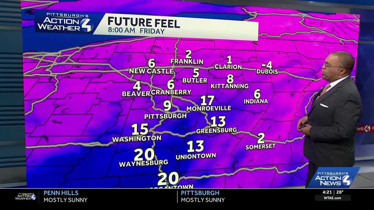
Impact Day: Record lows possible Friday morning
How cold it gets tonight will be location dependent. More clouds are expected to drift in from the south. This blanket of cloud cover should keep temps from falling as far for areas south of Pittsburgh. For areas north of Pittsburgh, clearing skies are more likely, therefore, the coldest/record challenging lows are possible north of Pittsburgh. Fortunately, the wind will be light so there will not be a much-added chill factor. Pittsburgh could tie or break our daily record low of 12° set in 1976 on Friday. Wind chills will be in the single digits in the morning. Temperatures will only return to near freezing Friday afternoon.

Not as cold for the weekend with Sunday snowflakes
Temperatures will warm a bit over the weekend with highs inching into the middle 30s. We are watching a system that will pass on Sunday that could bring some flurries to Western PA through the afternoon. Accumulation looks to be minimal.
Midweek rain and snow chance

Hearst Owned
Rain showers will likely start on Wednesday with an evening transition to snowflakes Thursday morning.
A better chance for a few snow or rain showers will come on Wednesday of next week. We could start with some flurries on Tuesday before we see rain showers on Wednesday as highs warm to near 40. As temperatures drop late Wednesday into Thursday, we will change the raindrops to snowflakes and see light snow on Thursday. At this point, little accumulation is expected.

Hearst Owned
Record cold possible Friday, then a few snow and rain chances through next week.
TONIGHT: Partly to mostly cloudy, bitter cold. Low 11°. (Record Low: 12°, 1976)
FRIDAY – Impact Day: Frigid start, Clouds & Sun. High: 33°
SATURDAY: Mostly cloudy. High: 36°, low: 21°.
SUNDAY: Mostly cloudy with flurries to light snow possible in the afternoon. High: 35°, low: 26°.