
IMPACT MORNING | South-central Pennsylvania braces for near-record frigid temperatures
LET’S TALK ABOUT THESE FRIGID TEMPS NEAR RECORD. WE MAY ACTUALLY HIT IT THIS MORNING. IT’S BEEN 99 YEARS SINCE IT’S BEEN 12 DEGREES ON THIS DAY. RIGHT, MIKE? YEAH THAT’S RIGHT. KATELYN HERE. SO I THINK A LOT OF FOLKS ARE GOING TO BE TURNING THE HEAT ON AS WE GO THROUGH THIS MORNING HERE, BECAUSE WE WILL HAVE A CHANCE TO SEE IF WE CAN GET THIS LOW HERE IN HARRISBURG RIGHT NOW IS A LITTLE TOO WARM, BUT NONETHELESS IT IS COLD OUTSIDE, EVEN IF WE DON’T HIT THE RECORD, BECAUSE RIGHT NOW TEMPERATURES ARE IN THE 20S IN HARRISBURG AS WELL AS LEBANON AND LANCASTER. BUT CHECK OUT SELINSGROVE DOWN TO 1116 THERE IN LEWISTOWN. THAT’S BECAUSE WE HAVE A CLEAR SKY, SO WE GET A CLEAR SKY OVER HARRISBURG AS AND ALSO LEBANON. CARLISLE. THOSE TEMPERATURES, I THINK WILL GET VERY CLOSE. AND WHEN WE LOOK AT THE TEMPERATURE AND WIND CHILLS FOR THE DAY, WE ARE EXPECTED TO SEE THOSE TEMPERATURES DROP A LITTLE BIT MORE THIS MORNING AND THEN GOING UP TO AROUND 30 DEGREES THIS AFTERNOON, BUT IT’S GOING TO FEEL LIKE THE TEENS ALL MORNING. AND THEN THE LOW TO MID 20S AS WE GO INTO YOUR FRIDAY AFTERNOON HERE. SO JUST MAKE SURE YOU BUNDLE UP. IT’S GOING TO BE COLD NO MATTER HOW YOU SLICE IT. HERE’S A LOOK AT STORM TEAM LIVE RADAR NETWORK, AND YOU CAN SEE THAT CLOUD LINE. IT’S RIGHT OVER HARRISBURG ACTUALLY HERE. SO AGAIN THAT CLOUD LINE JUST GOES A LITTLE BIT FARTHER SOUTH THAT WILL ALLOW THAT HEAT TO ESCAPE AND COOL THINGS OFF. NOW THE SNOW SHOWERS YOU SEE ON STORM TEAM LIVE RADAR NETWORK IS ACTUALLY PART OF THE SYSTEM THAT’S PASSING TO THE SOUTH HERE ACROSS PARTS OF VIRGINIA. THE CAROLINAS, ALSO MARYLAND. THERE A FEW FLURRIES ARE POSSIBLE ALONG THE PENNSYLVANIA MARYLAND BORDER THIS MORNING, BUT I DO THINK MOST OF US ARE GOING TO STAY DRY HERE. WE’RE JUST GOING TO BE DEALING WITH SOME OF THE CLOUDS. SO YOUR WEATHER HEADLINES, IT’S A FRIGID START TO THE DAY TODAY. A FEW SNOW SHOWERS AGAIN TO OUR SOUTH. AND AS WE GO INTO THE WEEKEND IT’S GOING TO BE A COLD WEEKEND. HIGHS REMAIN BELOW AVERAGE BOTH SATURDAY AND SUNDAY IN THE 30S. KEEP IN MIND WE SHOULD BE IN THE 40S THIS TIME OF YEAR. UNSETTLED PATTERN NEXT WEEK WITH A FEW CHANCES FOR RAIN OR SNOW SHOWERS. THAT LOOKS LIKE IT’S GOING TO BE MORE TOWARDS THE END OF THE WEEK, THOUGH. IF ANYTHING. LANCASTER THOUGH THIS MORNING HERE GOT THE CLOUDS OUTSIDE. AND WHEN WE TAKE A LOOK AT YOUR FORECAST FOR THE REST OF THE DAY TODAY, 18 THIS MORNING AS YOU’RE HEADING OFF TO WORK AND SCHOOL. SO IT IS GOING TO BE A CHILLY START, GETTING UP TO 30 DEGREES THOUGH WITH A MAINLY CLOUDY SKY THIS AFTERNOON AND THIS EVENING. A LOT OF EVENTS GOING ON AROUND THE SUSQUEHANNA VALLEY. MOSTLY CLOUDY WILL BE IN THE UPPER 20S, BUT IT’S GOING TO FEEL LIKE THE LOW 20S BECAUSE OF A LIGHT WIND HERE TONIGHT WILL DROP BACK INTO THE LOW TO MID 20S. MOSTLY CLOUDY, JUST CHILLY ACROSS THE AREA SO IT WILL BE MOSTLY CLOUDY. NIGHT TONIGHT AND THEN TOMORROW. MOSTLY CLOUDY AND COLD. ONCE AGAIN IT’S PRETTY MUCH JUST RINSE AND REPEAT WITH THIS AS WE GO THROUGH THE WEEKEND. WE’RE LOOKING AT UPPER 30S FOR HIGHS, SO THIS SYSTEM CONTINUES TO PUSH OFF TO THE EAST AS WE GO THROUGH THE AFTERNOON, WE’LL HAVE CLOUDS KEEPING US NICE AND COLD ACROSS THE AREA. AND AS WE GO INTO YOUR SATURDAY, WE ARE SEEING A MOSTLY CLOUDY SKY AS WELL. NOW ON SUNDAY WE WILL BE WATCHING A COLD FRONT THAT WILL BE PASSING THROUGH EARLY IN THE MORNING HERE. THERE’S ALSO A LITTLE BIT OF ENERGY THAT’S GOING TO PASS OVER THE SUSQUEHANNA VALLEY HERE. AS WE GO INTO SUNDAY AFTERNOON. THIS MODEL WANTS TO KEEP SNOW SHOWERS A LITTLE BIT FARTHER NORTH, BUT I WOULD NOT BE SURPRISED IF SUNDAY IF WE DO IN FACT SEE A LITTLE BIT OF SNOW SHOWERS THERE. SO WE’LL KEEP AN EYE ON THAT FOR YOU. LEWISTOWN FESTIVAL OF ICE LAST NIGHT IS TONIGHT. YOU WILL BE IN THE UPPER 20S, SO IT’S DEFINITELY COLD ENOUGH TO SUPPORT ANY ICE THAT WILL BE OUT THERE THIS EVENING. AND YOUR TEN DAY FORECAST. LIKE I SAID, COLD BUT DRY FOR MOST OF THE WEEKEND HERE. JUST GOT TO WATCH FOR A FEW SNOW SHOWERS LATE IN THE DAY ON SUNDAY, AND THEN IT’S GOING TO REMAIN CHILLY AS WE GO INTO NEXT WEEK. YOU CAN SEE A COUPLE CHANCES THERE FOR SOME RAIN AND SNOW AS WE HEAD INTO MAYBE THURSDAY AND ALSO THE FOLLOWING WEEKEND, BUT WE REMAIN BELOW AVERAGE KATELYN FOR THE ENTIR
IMPACT MORNING | South-central Pennsylvania braces for near-record frigid temperatures

Updated: 7:01 AM EST Dec 5, 2025
Near-record temperatures are possible in parts of the Susquehanna Valley, making Friday an Impact Morning. Very cold morning | Low temperatures in the lower-to-mid teens across the region north of the PA turnpike; High clouds are possible. Near-record low | Cold temperatures in some locations could approach the 1926 record of 12 degrees; Best chance for near-record low temperatures is in areas with a clear sky. Frigid Friday | High temperatures will only be in the upper 20s to lower 30s; Thicker, lower clouds return during the afternoon, limiting sunshine.A small storm system will pass south over Virginia, sending high clouds into the region. These clouds may keep temperatures slightly warmer south of the Pennsylvania Turnpike, preventing readings from dropping as low as areas to the north.Chance of snow near the Maryland Border A weather system sliding to our south on Friday may bring flurries or light snow showers.Best chance for flurries is Friday morning through early afternoon, mainly south of the Pennsylvania Turnpike.Dry air over southern Pennsylvania will keep most locations snow-free with little to no accumulation. Most measurable snowfall will remain south of the Maryland line. SOUTH-CENTRAL PA WEATHER RESOURCES: INTERACTIVE RADAR | ACTIVE WEATHER ALERTS | CURRENT CONDITIONS | HOURLY FORECAST | 10-DAY FORECAST | WEEKEND FORECAST | MAP ROOM | DOWNLOAD THE APP | WEATHER EMAILS
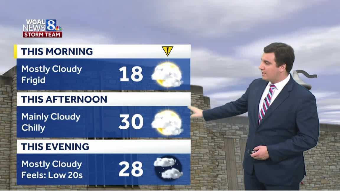
Near-record temperatures are possible in parts of the Susquehanna Valley, making Friday an Impact Morning.
Very cold morning | Low temperatures in the lower-to-mid teens across the region north of the PA turnpike; High clouds are possible.
Near-record low | Cold temperatures in some locations could approach the 1926 record of 12 degrees; Best chance for near-record low temperatures is in areas with a clear sky.
Frigid Friday | High temperatures will only be in the upper 20s to lower 30s; Thicker, lower clouds return during the afternoon, limiting sunshine.
A small storm system will pass south over Virginia, sending high clouds into the region. These clouds may keep temperatures slightly warmer south of the Pennsylvania Turnpike, preventing readings from dropping as low as areas to the north.
Chance of snow near the Maryland Border
A weather system sliding to our south on Friday may bring flurries or light snow showers.
Best chance for flurries is Friday morning through early afternoon, mainly south of the Pennsylvania Turnpike.
Dry air over southern Pennsylvania will keep most locations snow-free with little to no accumulation.
Most measurable snowfall will remain south of the Maryland line.
SOUTH-CENTRAL PA WEATHER RESOURCES: INTERACTIVE RADAR | ACTIVE WEATHER ALERTS | CURRENT CONDITIONS | HOURLY FORECAST | 10-DAY FORECAST | WEEKEND FORECAST | MAP ROOM | DOWNLOAD THE APP | WEATHER EMAILS