
Pittsburgh: Chilly weekend ahead with rain and snow next week
Highs will reach the middle 30s through the weekend.
AND KEEP THE SNOW THEY GOT FROM EARLIER THIS WEEK AS WELL. IT IS GOING TO REMAIN CLOUDY AS WE HEAD THROUGH THE WEEKEND. WE’RE GOING TO BE CHILLY STILL BELOW WHERE WE SHOULD BE, BUT NOT AS COLD AS WE HAVE BEEN. WE’LL WATCH FOR A FLURRY CHANCE ON SUNDAY. BEST SHOT IS LIKELY NORTH OF THE CITY. NOTHING REALLY STICKS OR ACCUMULATES AND WE GO BACK INTO THE DEEP FREEZER ON MONDAY. MONDAY WILL BE COOLER THAN WHERE WE’VE BEEN SO FAR THIS WEEK. 36 TOMORROW. WE’RE STARTING IN THE 20S, WHICH IS WHERE MANY OF US ARE STILL SITTING 35 DEGREES FOR US. ON YOUR SUNDAY, WE’LL WATCH FOR FLURRY CHANCE, MAINLY AFTER WE GET PAST LUNCHTIME. THE BEST CHANCE TO SEE ONE WILL BE NORTH OF THE CITY. THESE WILL BE LIGHT AND QUICK MOVING, AND AGAIN, WE’RE NOT EXPECTING MUCH IN THE WAY OF ACCUMULATION OUT OF THIS, BUT SOME SNOWFLAKES WILL FLY THAT DROPS OUR TEMPERATURES IN THE 20S FOR OUR HIGH ON MONDAY. AGAIN, THAT WILL BE COLDER THAN WHERE WE’VE BEEN SO FAR THIS WEEK. THEN TUESDAY WE BEGIN WATCHING FOR THE FIRST OF ANOTHER SET OF FLURRY CHANCES. TUESDAY AGAIN WILL LIKELY BE NORTH OF THE CITY, BUT THIS WILL BE BASED ON THE TIMING OF OUR NEXT SYSTEM. RIGHT NOW, IT LOOKS LIKE IT GETS HERE AS WE HEAD INTO WEDNESDAY. IF THIS SLOWS DOWN A BIT, WE COULD ACTUALLY SEE OUR FLURRY CHANCE HOLD OFF. WEDNESDAY WILL ACTUALLY SEE RAIN SHOWERS AS HIGH TEMPERATURES MAKE A RUN TOWARDS 40 FOR THE FIRST TIME THIS MONTH. THESE RAIN SHOWERS AND AS WE GET TOWARDS THE BACK PART OF THE DAY AND TEMPERATURES DROP, WE’LL TRANSITION OVER TO SNOWFLAKES AND THOSE COULD LINGER INTO OUR THURSDAY TEMPERATURE OF FREEZING ON THURSDAY, AND WE STAY COLD AS WE CLOSE OUT NEXT WEEK. A HIGH OF ONLY 30 NEXT FRIDAY, THEN BACK INTO THE 20S FOR HIGHS AND LOWS IN THE TEENS AS WE HEAD INTO NEXT SATURDAY. IT’S STILL CLOUDY OUT THERE ON ACTION CAM AGAIN. WE’RE KEEPING THE CLOUDS WITH US AS WE HEAD INTO THE WEEKEND. 29 IS THE CURRENT TEMPERATURE. WE’VE BEEN HOLDING PRETTY STEADY FOR THE LAST FEW HOURS. THAT’S THANKS TO THE CLOUDS THAT ARE IN PLACE. THE WIND IS LIGHT, SO IT FEELS A LITTLE COLDER THAN THE ACTUAL AIR TEMPERATURE. IT FEELS LIKE IT’S 23 OUTSIDE AS YOU HEAD OUT THE DOOR TOMORROW MORNING. IF YOU’RE HEADING OUT EARLY AGAIN, WE’LL BE INTO THE LOWER 20S, AND SO YOU’LL WANT ALL THE WINTER GEAR AS YOU HEAD OUT. YOU MAY SHED A LAYER OR TWO AS WE HEAD INTO THE AFTERNOON, AS WE SHOULD BREAK FREEZING FOR THE FIRST TIME SINCE TUESDAY ACROSS WESTERN PENNSYLVANIA.
Pittsburgh: Chilly weekend ahead with rain and snow next week
Highs will reach the middle 30s through the weekend.

Updated: 12:26 AM EST Dec 6, 2025
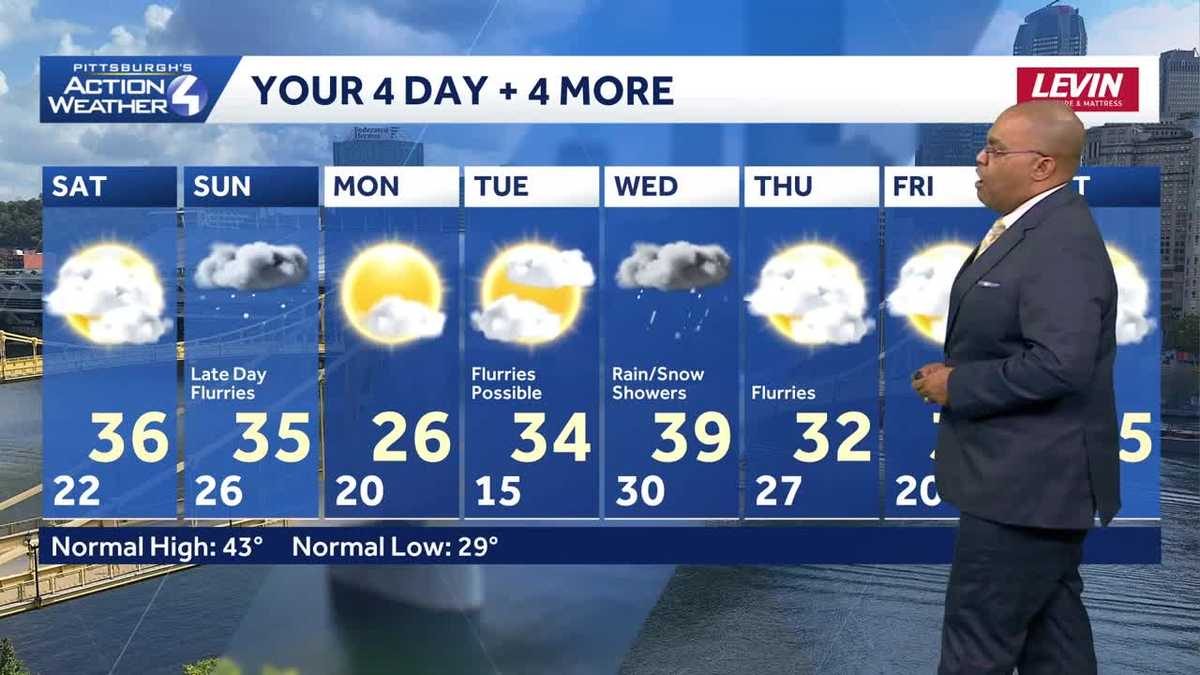
Pittsburgh remains the land of eternal clouds through the weekend. In addition, the below average chill will linger this weekend and well into next week.Not quite as cold this weekend with Sunday snowflakesTemperatures will be a tad bit warmer this weekend with highs inching into the middle 30s. As per usual of late, clouds will win over sun all weekend. We are watching a system that will pass on Sunday that could bring some flurries to Western PA. Little to no accumulation is expected.Midweek rain and snow chanceThe flurries will usher in colder air for Monday as we return to being stuck in the 20s through the day. A better chance for a few snow or rain showers will come on Wednesday of next week. We could start with some flurries on Tuesday before we see rain showers on Wednesday as highs warm to near 40. As temperatures drop late Wednesday into Thursday, we will change the raindrops to snowflakes on Thursday. At this point, little accumulation is expected. We turn the chill back on for next weekend.TONIGHT: Mostly cloudy. Low 22°.SATURDAY: Mostly cloudy. High: 36°, low: 26°.SUNDAY: Mostly cloudy with a few flurries. High: 35°, low: 20°.MONDAY: Partly cloudy and cold. High: 26°, low: 15°.
PITTSBURGH —
Pittsburgh remains the land of eternal clouds through the weekend. In addition, the below average chill will linger this weekend and well into next week.
Not quite as cold this weekend with Sunday snowflakes
Temperatures will be a tad bit warmer this weekend with highs inching into the middle 30s. As per usual of late, clouds will win over sun all weekend. We are watching a system that will pass on Sunday that could bring some flurries to Western PA. Little to no accumulation is expected.

Hearst Owned
Some flurries are possible on Sunday as a quick-moving system passes.
Midweek rain and snow chance
The flurries will usher in colder air for Monday as we return to being stuck in the 20s through the day.

A better chance for a few snow or rain showers will come on Wednesday of next week. We could start with some flurries on Tuesday before we see rain showers on Wednesday as highs warm to near 40. As temperatures drop late Wednesday into Thursday, we will change the raindrops to snowflakes on Thursday. At this point, little accumulation is expected. We turn the chill back on for next weekend.

Hearst Owned
Not as cold of a weekend with the best precipitation chances coming Wednesday.
TONIGHT: Mostly cloudy. Low 22°.
SATURDAY: Mostly cloudy. High: 36°, low: 26°.
SUNDAY: Mostly cloudy with a few flurries. High: 35°, low: 20°.
MONDAY: Partly cloudy and cold. High: 26°, low: 15°.