
Cloudy & colder than average conditions this evening; tracking rain/snow chances this week for south-central Pennsylvania
It’s an Impact Day for reduced air quality across the area until 8 PM this evening when winds will begin to pick up. We’re still tracking unsettled patterns this week that will allow for more rain/snow chances throughout the week.
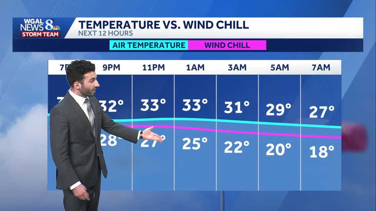
COLD AND A LITTLE BIT BRISK AS WE HEAD INTO THE OVERNIGHT PERIOD. BECOMING A LITTLE BREEZY AS WE GET INTO LATE OVERNIGHT, MONDAY’S FEELS LIKE TEMPERATURES STARTING OFF INTO THE TEENS AND EVENTUALLY THE 20S. BY THE TIME WE GET INTO LATER IN THE MORNING. THEN A FEW MORE, FEW MORE RAIN AND SNOW. CHANCES ARE ON THE WAY AS WE GET INTO NEXT WEEK. IT’S A LITTLE BIT OF AN UNSETTLED PATTERN THAT WE’LL BE FACING AS WE GET INTO THE WORKWEEK. TEMPERATURES RIGHT AROUND 40 DEGREES FOR TODAY. 46 IS WHAT WE EXPECT FOR THIS TIME OF THE YEAR, SO DEFINITELY BELOW AVERAGE FOR FOR THIS TIME OF THE YEAR. SO FOR THE REST OF THIS EVENING, WE LIFT THAT IMPACT ICON THERE FOR THE POOR AIR QUALITY. WE’LL START TO SEE SOME DECREASING CLOUDS AND LIGHTER WINDS BEGIN TO START TO PICK UP. AS WE GET INTO LATE THIS EVENING. TEMPERATURES RIGHT INTO THE LOWER 30S. PARTLY CLOUDY, TURNING, BREEZY. LATE, TEMPERATURES GETTING INTO THE MID 20S AND PARTLY SUNNY. BRISK AND COLD AS WE GET INTO TOMORROW. RIGHT AROUND 30 DEGREES. SO IN TERMS OF THE CHRISTMAS TREE LIGHTING FOR THE REST OF THIS EVENING, WE’LL SEE MORE OF THOSE DECREASING CLOUDS AND THE LIGHT BREEZE COMING IN LATE THIS EVENING. TEMPERATURES GOING INTO THE 30S. AS WE GET INTO AS WE GET INTO THE REST OF THIS EVENING. NOW, THE AIR QUALITY ALERT FOR TODAY, WE COULD SEE THERE’S SOME POOR AIR QUALITY ACROSS THE AREA. THAT’S WHAT TRIGGERED THIS, THIS CODE ORANGE AIR QUALITY ALERT FROM FROM EARLIER YESTERDAY. YOU SEE THAT’S STILL IN EFFECT. AND THAT WILL BE IN EFFECT FOR JUST A FEW MORE HOURS. WE’RE GOING TO LEAVE THE IMPACT PERIOD UP UNTIL 8:00 THIS EVENING FOR CUMBERLAND, DAUPHIN, LEBANON, LANCASTER AND YORK COUNTIES FOR THE DAY. SO YOU CAN SEE UP UNTIL 8:00 THIS EVENING FOR THAT HIGH PARTICULATE MATTER. AND THAT’S WHAT’S REDUCING THE AIR QUALITY, BY THE WAY. THAT’S WHAT’S IN THE AIR. AND IT’S IT’S IT’S UNHEALTHY FOR SENSITIVE GROUPS. THOSE WHO ARE KIDS, THE ELDERLY, THOSE WHO HAVE LUNG OR HEART COMPLICATIONS AND ALSO ASTHMA FOR AS ANOTHER REASON THERE. SO JUST JUST REFRAIN FROM ANY STRENUOUS ACTIVITY. BUT THE BIGGER STORY HERE IS, AS WE GET INTO THE NEXT 12 HOURS, I WANT TO SHOW YOU THE TEMPERATURES VERSUS THE WIND CHILL. AS THE BREEZE INCREASES, WHAT HAPPENS TO THE FEELS LIKE TEMPERATURES FEELING LIKE 22 BY THE TIME WE MAKE IT TO OVERNIGHT TONIGHT, WITH AIR TEMPERATURES RIGHT AROUND THE LOWER 30S AND THEN FEELING LIKE 2018 DEGREES AS YOU GET CLOSER TOWARDS THE MONDAY MORNING COMMUTE. AND THEN AS WE GET INTO THE AFTERNOON, LOOK AT THIS FEELING LIKE 16 DEGREES. EVEN THOUGH AIR TEMPERATURES ARE RIGHT INTO THE MID 20S, BY 10:00 IN THE MORNING, IT’S GOING TO BE A COLD FEELING DAY. IT’S GOING TO BE A BRISK DAY OUTSIDE. AND HERE’S THE HIGH TEMPERATURES FOR THE NEXT SEVERAL DAYS. YOU CAN SEE WE’RE GOING DOWN TO 30 DEGREES FOR TOMORROW AFTERNOON. WE REBOUND CLOSE TO 40 DEGREES FOR WEDNESDAY. BUT LOOK AT THIS. WE’RE STILL BELOW AVERAGE, THOUGH FOR THE ENTIRETY OF THE WEEK AND EVEN GETTING INTO NEXT WEEKEND WHERE TEMPERATURES ARE GOING TO BE GETTING INTO THE LOWER 30S AND EVEN FOR THE NEXT 8 TO 14 DAYS. THIS IS VALID FROM DECEMBER 15TH THROUGH DECEMBER 21ST. STILL LOOKING BELOW AVERAGE FOR REALLY THE ENTIRE AREA. TEMPERATURES INTO THE 30S. RIGHT NOW YOU CAN SEE 37 IN LANCASTER, YORK, GETTYSBURG AND CHAMBERSBURG, 36 IN THE CAPITAL, AND ALSO IN LEWISTOWN AT THIS TIME, CURRENT WINDS ARE CALM, BUT THEY WILL BEGIN TO INCREASE AS WE GET INTO THE OVERNIGHT PERIOD AND ALSO INTO LATE TOMORROW MORNING. YOU CAN SEE GETTING UP BETWEEN 5 AND 10MPH AND EVEN BEYOND. NOW WE’RE WATCHING JUST A FEW SNOW SHOWERS YOU CAN SEE UP TOWARDS OUR FAR NORTHWESTERN COMMUNITIES, NOT REALLY LOOKING AT A WHOLE LOT OF ACCUMULATION WITH THE WITH THIS, THIS, THIS LITTLE BRIEF ENERGY THAT’S PASSING BY. THAT’S ALL THANKS TO AN INCOMING COLD FRONT THAT’S GOING TO PASS THROUGH THE VALLEY AS WE GET INTO THE OVERNIGHT PERIOD. AND THAT’S WHAT’S GOING TO BE TRIGGERING THE BLUSTERY AND COLDER CONDITIONS AS WE GET INTO OUR MONDAY. AND ALSO GETTING INTO THE REST OF THE WEEK. GOT SOME HIGH PRESSURE BUILDING IN THAT WILL HELP TO CLEAR OUR SKIES AS WE GET INTO MONDAY SLIGHTLY, AND THEN ALSO A LITTLE BIT INTO THE EARLY MORNING HOURS FOR TUESDAY. SO TEN DAY FORECAST LOOKING A LITTLE BIT UNSETTLED AS WE GET INTO THE WORKWEEK, AND ALSO A
Cloudy & colder than average conditions this evening; tracking rain/snow chances this week for south-central Pennsylvania
It’s an Impact Day for reduced air quality across the area until 8 PM this evening when winds will begin to pick up. We’re still tracking unsettled patterns this week that will allow for more rain/snow chances throughout the week.

Updated: 8:04 PM EST Dec 7, 2025
An Air Quality Alert has been issued for Lancaster, York, Dauphin, Cumberland, Lebanon counties until Sunday at 8 PM by the Pennsylvania Department of Environmental Protection. The low levels of the current air mass that is overhead has become stagnant; therefore this stale air will reduce air quality across portions of our area, making the air unhealthy for sensitive groups. Kids, elderly, and individuals with lung/heart complications should reduce any strenuous outdoor activity today.Expect decreasing clouds this evening, temperatures will drop through the lower 30s throughout the evening.Tonight, expect partly cloudy skies with an increasing breeze coming out of the north. Temperatures will bottom out in the mid 20s overnight. Behind the front comes another rush of colder air for Monday. In fact, highs will take place in the low 30s after midnight, then temperatures will fall to the mid and upper 20s by morning and only recover to near 30° for the afternoon. However, gusty winds will make it feel like the teens and 20s much of the day. Skies will be partly sunny.Tuesday, lows are in the teens and with plenty of cloud cover, temperatures only climb to the low 30s. With a bit of a breeze, it will make it feel colder in the 20s. A few flurries can’t be ruled out but the day is dry.A fast-moving clipper diving into the area Tuesday night into early Wednesday will bring a chance for rain and/or snow showers. Highs are the warmest of the week, around 40 degrees.Another clipper Thursday night into Friday may bring flurries or snow showers. The main story is the below average chill remains throughout the 10 Day Forecast.Have a great rest of your evening!~ Ryan
An Air Quality Alert has been issued for Lancaster, York, Dauphin, Cumberland, Lebanon counties until Sunday at 8 PM by the Pennsylvania Department of Environmental Protection. The low levels of the current air mass that is overhead has become stagnant; therefore this stale air will reduce air quality across portions of our area, making the air unhealthy for sensitive groups. Kids, elderly, and individuals with lung/heart complications should reduce any strenuous outdoor activity today.
Expect decreasing clouds this evening, temperatures will drop through the lower 30s throughout the evening.
Tonight, expect partly cloudy skies with an increasing breeze coming out of the north. Temperatures will bottom out in the mid 20s overnight.
Behind the front comes another rush of colder air for Monday. In fact, highs will take place in the low 30s after midnight, then temperatures will fall to the mid and upper 20s by morning and only recover to near 30° for the afternoon. However, gusty winds will make it feel like the teens and 20s much of the day. Skies will be partly sunny.
Tuesday, lows are in the teens and with plenty of cloud cover, temperatures only climb to the low 30s. With a bit of a breeze, it will make it feel colder in the 20s. A few flurries can’t be ruled out but the day is dry.
A fast-moving clipper diving into the area Tuesday night into early Wednesday will bring a chance for rain and/or snow showers. Highs are the warmest of the week, around 40 degrees.
Another clipper Thursday night into Friday may bring flurries or snow showers. The main story is the below average chill remains throughout the 10 Day Forecast.
Have a great rest of your evening!
~ Ryan