
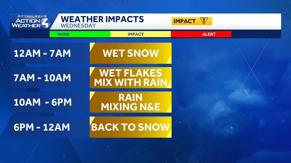
Wednesday is an Impact Day as a messy system moves in with a period of wet snow overnight, followed by rain during the day, then ending as more snow. Be aware of changing road conditions as precipitation types change.What you need to know: Precipitation typesWet snow will arrive as early as midnight for areas to the north. The entire area will see off and on wet flakes through wake up. Warmer air surges in from the south after sunrise. A brief period of wet snow mixed with rain is expected, before everything changes over to a plain rain. The rain will fall for the better part of the day, and is the primary precipitation type. For the ridges and areas north of I-80, the mixing could last longer.But, we’re not done yet. On the tail end of the evening commute, we will see a precipitation type change again, back to snow. Roads may become slick and icy as temperatures drop and the snow flies again. Most of the area will see minimal accumulations. On the high side, two to four inches for the I-80 corridor; the ridges could pick up a few inches too. Winter weather alertsA Winter Weather Advisory will be in effect for Clarion, Forest, Mercer, and Venango counties between 1 a.m. and 10 p.m. Wednesday.Snow is expected for the I-80 corridor with total accumulations of 2 to 4inches, locally up to 5 inches. Gusty winds up to 35 mph are also possible. Difficult travel conditions will impact both the Wednesday morning and evening commutes.The National Weather Service may introduce winter alerts for the ridges of the Westmoreland and Fayette counties, as well as Preston and Tucker counties in West Virginia. A longer period of mixing could potentially impact travel in these areas too.How much snow will my neighborhood see?The rain for the majority of this storm will cut down snow totals for most of western Pennsylvania. Accumulations are possible during both the morning and evening rounds of snow along I-80 and for the ridges. This will be a heavy wet snow – good for snow balls, but difficult to shovel.
PITTSBURGH —
Wednesday is an Impact Day as a messy system moves in with a period of wet snow overnight, followed by rain during the day, then ending as more snow. Be aware of changing road conditions as precipitation types change.

Hearst OwnedHearst
Changing precipitation types will lead to travel impacts Wednesday.
What you need to know: Precipitation types
Wet snow will arrive as early as midnight for areas to the north. The entire area will see off and on wet flakes through wake up. Warmer air surges in from the south after sunrise.

Hearst OwnedHearst
2 a.m. Futurecast: Wet snow arrives
A brief period of wet snow mixed with rain is expected, before everything changes over to a plain rain. The rain will fall for the better part of the day, and is the primary precipitation type. For the ridges and areas north of I-80, the mixing could last longer.

Hearst OwnedHearst
9 a.m. Futurecast: The changeover to rain begins south of Pittsburgh.
But, we’re not done yet. On the tail end of the evening commute, we will see a precipitation type change again, back to snow. Roads may become slick and icy as temperatures drop and the snow flies again. Most of the area will see minimal accumulations. On the high side, two to four inches for the I-80 corridor; the ridges could pick up a few inches too.

Hearst OwnedHearst
5 p.m. Futurecast: A transition back to snow begins to the northwest late afternoon/evening.
Winter weather alerts
A Winter Weather Advisory will be in effect for Clarion, Forest, Mercer, and Venango counties between 1 a.m. and 10 p.m. Wednesday.

Hearst OwnedHearst
A Winter Weather Advisory throughout the day Wednesday for counties along I-80.
Snow is expected for the I-80 corridor with total accumulations of 2 to 4inches, locally up to 5 inches. Gusty winds up to 35 mph are also possible. Difficult travel conditions will impact both the Wednesday morning and evening commutes.
The National Weather Service may introduce winter alerts for the ridges of the Westmoreland and Fayette counties, as well as Preston and Tucker counties in West Virginia. A longer period of mixing could potentially impact travel in these areas too.
How much snow will my neighborhood see?
The rain for the majority of this storm will cut down snow totals for most of western Pennsylvania. Accumulations are possible during both the morning and evening rounds of snow along I-80 and for the ridges. This will be a heavy wet snow – good for snow balls, but difficult to shovel.

Hearst OwnedHearst
Snow accumulations for Wednesday’ storm are expected for I-80 and the ridges.