
CLEVELAND, Ohio — Winter is beginning to leave its first fingerprints on Lake Erie.
Some ice has formed along the lake’s western edge, though federal scientists say these patches represent only the earliest stages of freeze-up, not the onset of lakewide ice.
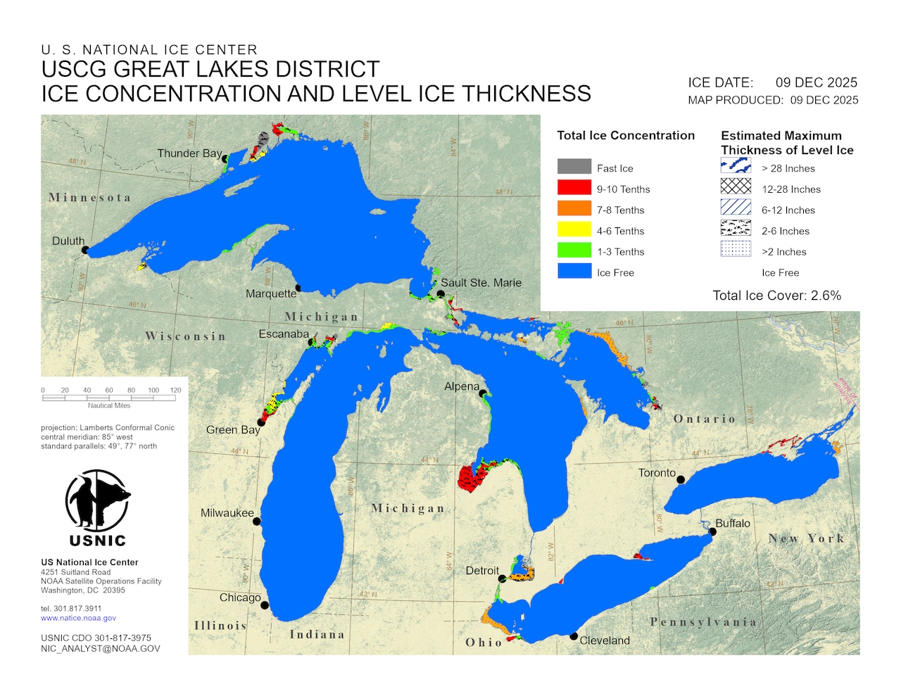
The latest ice map from the U.S. National Ice Center shows ice along the western shoreline, including in Maumee Bay and Sandusky Bay — areas that often freeze earlier because the western basin and the bay is shallower than the rest of the lake.
The localized ice follows several days of below-normal temperatures and can be seen on a live cam at Crane Creek in Ottawa National Wildlife Refuge.
According to the National Oceanic and Atmospheric Administration’s Great Lakes Environmental Research Laboratory, ice covered about 1.95% of Lake Erie on Dec. 9 and 1.58% on Dec. 10.
Both readings are enough to register on NOAA’s basin-wide analysis but remain well short of what the agency considers true, season-starting ice.
“We keep track of ice as a lake-wide average and often use 10% coverage as the threshold for ice on,” said James Kessler, a physical scientist with the lab. “Lake Erie has not yet exceeded 10%, so I would say that ice has not yet substantially formed.”
What the 10% threshold means
NOAA’s long-term records — which date to 1973 — show Lake Erie typically surpasses 10% ice cover in late December or early January. Colder winters can reach that mark earlier, while milder years tend to lag well into January.
Several recent winters, including 2022–23 and 2011–12, never reached the 10% mark at all.
This year’s shoreline ice formed during a stretch of daytime highs in the 20s and lower 30s, which briefly cooled surface temperatures enough for thin, localized freezing. But conditions haven’t remained cold or calm enough for ice to expand across the lake’s interior.
The recent daily fluctuations in the ice coverage are typical early in the season, when localized ice can shift or melt quickly with changes in wind and temperature.
Satellite-derived ice charts show more significant freeze-up underway on parts of Lake Superior, northern Lake Michigan and the St. Marys River. The upper lakes typically develop ice earlier in the season.
When will Cleveland see ice on Lake Erie?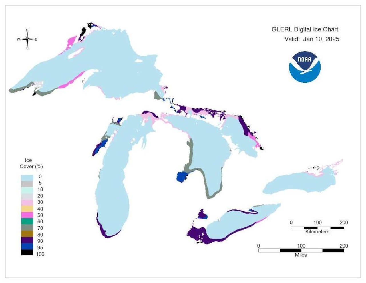 Last winter, Northeast Ohio didn’t see ice along the shoreline of Lake Erie until Jan. 10, 2025. Ice formation near Cleveland doesn’t typically occur until mid to late January.Courtesy NOAA Great Lakes Environmental Research Laboratory
Along the Northeast Ohio shoreline, ice first appeared around Jan. 10 last winter, based on NOAA’s archived ice maps.
Lakewide ice levels also remained well below average during that season.
The pattern held in 2024, as well, when shoreline ice did not form until Jan. 22.
Coast Guard icebreaking begins — but not on Lake Erie
While Lake Erie remains mostly open water, ice formation elsewhere prompted the U.S. Coast Guard to begin annual operations this week.
The Coast Guard launched Operation Taconite on Dec. 10 to assist commercial shipping where ice has begun to hinder vessel traffic, according to a news release.
The operation covers Lake Superior, Lake Michigan, the St. Marys River, the Straits of Mackinac and Georgian Bay. No icebreaking assets have been assigned to Lake Erie yet.
The Coast Guard urged caution for anyone venturing onto early-season ice, noting that thin, patchy formation is unstable and unsafe.
What to expect next
Lake Erie’s ice footprint can expand quickly once sustained Arctic air arrives, and this weekend’s weather may briefly encourage additional shoreline formation.
An Arctic front sweeping across Northeast Ohio on Saturday night will drop temperatures into the low teens, with wind chills below zero. Those conditions could allow thin, patchy ice to develop along portions of the shoreline, similar to what has formed this week.
Any early-season ice likely won’t last long, though. Temperatures are expected to rebound early next week, climbing from the 20s on Monday into the lower 40s by Wednesday, with a midweek system bringing rain. Warmer air and precipitation would erode any thin shoreline ice that forms over the weekend.