
IMPACT: Light snow overnight Saturday, then bitter cold Sunday across south-central Pennsylvania
A quick-moving system will bring light snow across the area late Saturday, exiting by sunrise Sunday. Strong winds and cold temperatures will lead to single-digit wind chills all day on Sunday across the Susquehanna Valley.
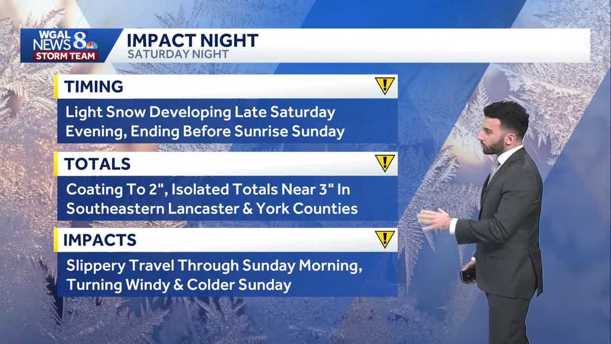
EVERYTHING. WE’LL BE STOPPING BY. ALL RIGHT. LET’S GET A CHECK NOW ON THE WEATHER FORECAST. AND BOY, THERE’S NOT A WHOLE LOT GOOD TO SAY ABOUT THIS WEEKEND. MAYBE EARLY IN THE DAY ON SATURDAY, BUT AFTER THAT, IT GOES DOWNHILL, RIGHT? YEAH. YOU’RE RIGHT JERRY. YEAH. SO WE’RE GOING TO WE’RE GOING TO START TO SEE SOME OF THAT LIGHT SNOW. NOW THE WINTER WEATHER LOVERS I’LL SAY, ARE PROBABLY GOING TO BE APPRECIATING THIS ONE. BUT YEAH, WE’RE GOING TO START TO SEE SOME SNOW COMING IN AS WE GET INTO LATE SATURDAY GETTING INTO SUNDAY. SO WE’RE GOING TO START TO SEE SOME INCREASING CLOUDS OVERNIGHT. WE’RE MAINLY CLEAR RIGHT NOW, BUT AS WE GET HAVE THIS NEXT DISTURBANCE MOVING IN, THAT’S WHEN WE’LL START TO SEE MORE OF THOSE CLOUDS ROLL THROUGH. THEN AS WE GET TO SATURDAY NIGHT WE HAVE THE IMPACT ICON THERE. THAT’S NOT FOR SATURDAY DURING THE DAY. DURING THE DAY IS FINE. IT’S WHEN WE GET TO SATURDAY NIGHT. THAT’S WHEN WE’LL HAVE THAT LIGHT SNOW START TO MOVE INTO THE AREA AND ALLOW FOR POSSIBLY A COATING TO TWO INCHES OF SNOW TO DROP IN SOME COMMUNITIES. BUT THEN WE HAVE SUNDAY AS AN IMPACT DAY AS WELL. AND THIS IS FOR THE SINGLE DIGIT WIND CHILLS AS WE GET INTO OUR SUNDAY. I’LL SHOW YOU THAT HERE IN JUST A MINUTE. BUT THESE THIS IS WHAT WE’RE GOING TO BE TRACKING AS WE GET INTO THE NEXT FEW DAYS HERE INTO THE WEEKEND. SO TEMPERATURES HIT RIGHT AROUND 36 TODAY. AVERAGE FOR THIS TIME OF THE YEAR IS 44. WE ARE STILL BELOW AVERAGE IN TERMS OF TEMPERATURES FOR THIS TIME OF YEAR. NO RAINFALL RECORDED AT HARRISBURG INTERNATIONAL AIRPORT. NOW, IN TERMS OF OVERNIGHT TONIGHT, LIKE I MENTIONED, WE’LL START TO SEE SOME OF THE CLOUDS ROLL IN, STILL CALM AND COLD. WE’LL HAVE A FIVE MILE PER HOUR BREEZE FROM THE NORTHWEST, TURNING SOUTHEAST 22 TO 26 DEGREES. THEN FOR TOMORROW MORNING, STARTING COLD, IT’LL BE BRISK, A LITTLE BIT OF A LIGHT BREEZE IN THE AIR, BUT WE’LL SEE MOSTLY CLOUDY CONDITIONS WITH A SOUTH SOUTHWESTERLY BREEZE BETWEEN 5 AND 10MPH RIGHT INTO THE UPPER 20S. WILL GO AND THEN FOR THE AFTERNOON LOOKING AT THE MID MID TO UPPER 30S FOR OUR DAYTIME HIGHS. BUT THEN ONCE WE GET INTO LATER IN THE EVENING, THAT’S WHEN WE’LL START TO SEE THE DEVELOPMENT OF A FEW FLURRIES START TO COME IN, THEN SOME LIGHT SNOW LATE ON SATURDAY. SO LET’S CHAT ABOUT THAT. WE’VE MADE SATURDAY NIGHT AN IMPACT NIGHT FOR LIGHT SNOW DEVELOPING LATE IN THE EVENING AND THEN ENDING BEFORE SUNRISE ON SUNDAY. I’D SAY RIGHT AROUND LIKE 4 OR 5:00 IN THE MORNING. I’D SAY TOTALS. LOOKING AT A COATING TO TWO INCHES OF SNOW COULD SEE SOME ISOLATED TOTALS NEAR THREE INCHES TOWARDS SOUTHEASTERN COMMUNITIES IN LANCASTER AND YORK COUNTY. SO, FOR EXAMPLE, IF YOU’RE IN FAWN GROVE OR DELTA, EVEN TOWARDS QUARRYVILLE, FOR EXAMPLE, TOWARDS SOUTHERN LANCASTER COUNTY, IF YOU GUYS ARE LISTENING TO THIS, YOU’RE WHERE THE BETTER CHANCES OF YOU HAVING THOSE ISOLATED TOTALS NEAR THREE INCHES IS A LITTLE BIT BETTER. BUT FOR THE MAJORITY OF THE AREA, REALLY LOOKING AT A COATING TO TWO INCHES. BUT JUST WATCH OUT FOR SLIPPERY TRAVEL THROUGH SUNDAY MORNING AS WE GET INTO THE AS WE GET INTO THE WEEKEND. SO IN TERMS OF TRAVEL CONDITIONS COULD BE SLOW AT TIMES, CLOSINGS AND DELAYS. SOME MAY BE POSSIBLE. POWER OUTAGES ARE LOW, VISIBILITY WILL BE FAIR AS WE GET INTO SATURDAY NIGHT AND EARLY SUNDAY MORNING. NOW HERE’S PREDICTOR SNOWFALL AS WE GET INTO OUR SATURDAY NIGHT. THIS IS WHAT WE’RE SEEING. SO YOU CAN SEE A LOT OF OUR AREA, MOST OF THE AREA LOOKING LIKE WE’RE STARTING TO SEE MORE OF THAT TWO INCH THRESHOLD BEGINNING TO COME AROUND THE CORNER. YOU SEE ALMOST ABOUT 2.6IN FOR LANCASTER, 2.1IN FOR YORK. YOU CAN SEE RIGHT, RIGHT AROUND 3.2IN FOR GETTYSBURG. BUT THAT’S ALL THANKS TO SOUTH MOUNTAIN, BECAUSE YOU’RE IN THE HIGHER ELEVATIONS, MOST OF THE AREA SEEING LESS THAN THAT, SEEING ABOUT A COATING TO AN INCH, INCH AND A HALF FOR FOR OUR NORTHWESTERN AREAS. THEN HERE COMES SUNDAY. LET’S CHAT ABOUT SUNDAY. LOOK AT THE WIND GUSTS GETTING UP TO ABOUT 29 30MPH. WE COULD SEE 35MPH BEING GUSTED. BUT THEN LOOK AT THE WIND CHILLS AS WE GET INTO SUNDAY. AIR TEMPERATURE INTO THE 20S, AND THEN INTO THE SINGLE DIGITS AS WE GET INTO THE AFTERNOON AND EVENING. AND BECAUSE OF IT FEELING SO COLD, WE’VE ALSO MADE SUNDAY AN IMPACT DAY, AND WE COULD BE SEEING SOME BLOWING SNOW. BY THE WAY, ISOLATED POWER OUTAGES MAY BE POSSIBLE, SO YOU’RE GOING TO WANT TO MAKE SURE YOU SECURE YOUR CHRISTMAS DECORATIONS. GOING TO BE FEELING LIKE THE SINGLE DIGITS THROUGHOUT THE ENTIRE DAY ON SUNDAY. TEMPERATURES INTO THE 20S RIGHT NOW. STORM TEAM, LIVE RADAR NETWORK. ALL IS QUIET. BUT THEN AS WE GET INTO THE WEEKEND, HERE COMES MORE OF THAT CLOUD COVER. WE’LL HAVE A COLD FRONT START TO PUSH THROUGH, AND THEN HERE COMES OUR NEXT DISTURBANCE COMING IN FROM THE WEST LATE SATURDAY INTO OVERNIGHT SUNDAY. OR EXCUSE ME, OVERNIGHT SATURDAY INTO EARLY SUNDAY. THAT’S WHAT I MEANT TO SAY. YOU SEE THAT PUSHES OUT BY 7:00 IN THE MORNING SUNDAY. BUT THEN MAN IT REALLY BECOMES A COLD AND BLUSTERY AS WE GET INTO THE SECOND HALF OF THE WEEKEND. LOOKING AHEAD INTO NEXT WEEK, BIT OF A BLUSTERY AND COLD START, BUT THEN LOOK AT THESE TEMPERATURES GUYS. WEDNESDAY, THURSDAY INTO THE WEEKEND. GETTING BACK TO
IMPACT: Light snow overnight Saturday, then bitter cold Sunday across south-central Pennsylvania
A quick-moving system will bring light snow across the area late Saturday, exiting by sunrise Sunday. Strong winds and cold temperatures will lead to single-digit wind chills all day on Sunday across the Susquehanna Valley.

Updated: 10:49 PM EST Dec 12, 2025
Tonight, lows will fall to the low 20s, and clouds will gradually increase.Saturday will feature mostly cloudy skies. There may be a few flurries throughout the day, but they won’t slow you down. Highs will reach the upper 30s to near 40 degrees, with light winds.IMPACT SATURDAY NIGHT & SUNDAY:We’re watching another quick-moving system that will bring light snow or snow showers late Saturday evening into early Sunday. Right now, a coating to 2″ of snow is likely for most of the area, with isolated totals approaching 3″ in southern York and Lancaster Counties.Be on the lookout for slippery roads overnight Saturday into Sunday morning. The system will exit by sunrise Sunday, and temperatures will hold steady in the low to mid-20s for most of the day. It will also turn blustery, with NW winds 15-25 mph and gusts to 35 mph. That will make it feel like the single digits all day Sunday!The forecast looks dry and cold Monday and Tuesday, as high pressure moves overhead. Highs won’t get out of the 20s on Monday, but Tuesday’s highs will be near freezing.Temperatures will warm to the low-to-mid 40s on Wednesday and the upper 40s on Thursday. Rain is back in the forecast on Thursday as a cold front passes.Temperatures cool to near 40 degrees at the end of the week, which is average for this time of the year.Another chance of rain showers is in the forecast for Saturday, followed by a dry and milder Sunday.Have a great weekend!~ Ryan
Tonight, lows will fall to the low 20s, and clouds will gradually increase.
Saturday will feature mostly cloudy skies. There may be a few flurries throughout the day, but they won’t slow you down. Highs will reach the upper 30s to near 40 degrees, with light winds.
IMPACT SATURDAY NIGHT & SUNDAY:
We’re watching another quick-moving system that will bring light snow or snow showers late Saturday evening into early Sunday. Right now, a coating to 2″ of snow is likely for most of the area, with isolated totals approaching 3″ in southern York and Lancaster Counties.
Be on the lookout for slippery roads overnight Saturday into Sunday morning. The system will exit by sunrise Sunday, and temperatures will hold steady in the low to mid-20s for most of the day. It will also turn blustery, with NW winds 15-25 mph and gusts to 35 mph. That will make it feel like the single digits all day Sunday!
The forecast looks dry and cold Monday and Tuesday, as high pressure moves overhead. Highs won’t get out of the 20s on Monday, but Tuesday’s highs will be near freezing.
Temperatures will warm to the low-to-mid 40s on Wednesday and the upper 40s on Thursday. Rain is back in the forecast on Thursday as a cold front passes.
Temperatures cool to near 40 degrees at the end of the week, which is average for this time of the year.
Another chance of rain showers is in the forecast for Saturday, followed by a dry and milder Sunday.
Have a great weekend!
~ Ryan