
SHORT TERM FORECAST
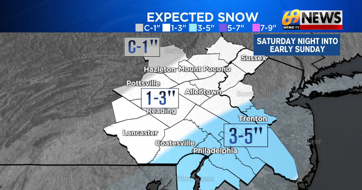
TONIGHT: Cloudy with snow developing this evening, steadiest overnight, and tapering off towards sunrise. 1-3″ for many but 3-5″ south of I-78. Low: 23
SUNDAY: Snow showers ending early, then clouds breaking for some sun, breezy, and cold. Wind chills in the single digits and teens. High: 27
SUNDAY NIGHT: Mostly clear to partly cloudy, breezy, and quite cold. Wind chills in the single digits to near 0 degrees. Low: 15
_______________________________________________________________________________________________________________________________________________________________________________________________________________________________
FORECAST SUMMARY
Get ready for a wintry latter part of the weekend! After Saturday featured seasonably chilly afternoon highs in the mid to upper 30s with mostly cloudy skies, there’s a reinforcing shot of arctic air on the way. But not only that, we also have some area-wide accumulating snow just ahead of that next arctic blast, with a round of snow expected to bring a few inches of light and fluffy snow for most overnight tonight. For the heart of the I-78 corridor including much of the Lehigh Valley, Berks County, and west-central New Jersey, we now expect snowfall amounts to run pretty close to 3 inches with perhaps even a few 4 inch amounts possible. For the Poconos, Schuylkill County, and far northwestern New Jersey, lighter amounts of snow on the order of 1 to 3 inches are expected. The big winners for snow totals will be areas south of I-78 and especially getting down to the Delaware Valley and most of southern New Jersey where easily 3 to 5 inches of snow is expected. And it would not be surprising to see a couple 6 inch reports in the I-95 corridor between the Delaware Valley and southwestern New Jersey. Most of the snow falls tonight, when all the accumulations are expected to occur, as well as the slickest travel. Expect wind chills to drop into the single digits and teens Sunday through Monday as the next cold blast arrives, with some blowing snow as well due to the lightweight nature of any snow that falls. While cold, it will be a dry start to the work and school week Monday and Tuesday, with the cold finally easing, albeit briefly, later in the week with a brief shot of warmth and even some rain come late Thursday and Thursday night.

DETAILED FORECAST
***WINTER WEATHER ADVISORY IN EFFECT FOR MUCH OF THE REGION SOUTH OF BLUE MOUNTAIN. WINTER STORM WARNING IN EFFECT FOR THE I-95 CORRIDOR BETWEEN PHILLY, TRENTON, AND WILMINGTON***
TONIGHT
Our quick-hitting shot of mostly light and fluffy snow will be a mostly overnight event, arriving from west to east during the evening hours, and falling steadiest from around 11pm to 4am, then tapering off toward sunrise. It’s a lightweight snow that will be easy to clean up, but also blow around a bit once the winds pick up on Sunday. Right now, 1-3″ of snow is expected north of I-78, with 3-5″ amounts south of I-78 and the highest totals coming from the Delaware Valley, along the I-95 corridor, and through most of southern Jersey where a couple 6 inch reports can’t entirely be ruled out. Lows will be in the low to mid 20s, so this will be mainly all snow, with the one exception being maybe a little rain and/or sleet to start for those south and east of I-95. With the cold air and cold ground, expect snow to accumulate on all surfaces, and some slick travel mostly overnight, but lingering into early Sunday morning, especially points south and east where the snow is a little steadier and last to taper off.
SUNDAY AND MONDAY
Any early morning snow around sunrise Sunday morning, mainly from the Delaware Valley to the shore, will quickly end. Then the focus turns to our next shot of arctic air, which will arrive during the day on Sunday, and last through Tuesday morning. Expect temps to actually hold steady or slowly fall through the 20s on Sunday once any snow ends, with skies clearing up a little and a brisk northwest breeze increasing (10-15mph, gusts to 25-30mph). That will lead to some blowing of that fluffy freshly fallen snow, and cold wind chills in the single digits and teens. It will be brisk and very cold Sunday night as skies turn out mainly clear to partly cloudy. Look for lows to dip down into the mid teens Sunday night, but with the wind factored in, it will feel more like it’s in the single digits to perhaps even a few sub-zero readings. Daytime highs will remain in the 20s Monday under mostly cloudy skies. Monday night will feature fair skies with lows again in the teens and wind chills in the single digits.
TUESDAY
This should be the last very cold day for a little while, but it should come with a break from the biting breezes of Sunday and Monday. Look for partly sunny skies and lighter winds, with morning temps in the teens and afternoon highs in the low 30s.
LATER NEXT WEEK
After about three weeks, we’ll finally see milder than average temperatures, if only for a day, on Thursday next week. For Wednesday, expect partly sunny skies and highs inching into the low 40s, finally closer to seasonable levels for mid-December. We’ll do even better than that on Thursday, with mostly cloudy skies but milder highs in the upper 40s. The price we pay will be an increasing southwest breeze, and some rain showers later Thursday and Thursday night. Behind those showers, we’ll return to cooler (but not bitter cold) temps on Friday with highs back in the upper 30s with a brisk breeze.
TRACK THE WEATHER:
LINKS: HOUR BY HOUR | RADAR | TRAFFIC