
IMPACT: Snow developing this evening into tonight, then bitter cold sets up Sunday across south-central Pennsylvania
A quick-moving system will bring light snow across the Susquehanna Valley this evening and exit by sunrise Sunday. Strong winds and cold temperatures will lead to single-digit wind chills all day on Sunday.
TONIGHT AFTER NEWS EIGHT AT 11. THE SNOW IS FALLING ACROSS PORTIONS OF THE AREA RIGHT NOW. STARTING TO SEE SOME OF THAT SNOW MOVE INTO OUR NORTHWESTERN COMMUNITIES AND WESTERN COMMUNITIES TOWARDS FRANKLIN AND ADAMS COUNTY, TOWARDS SOUTH MOUNTAIN, TOWARDS MIFFLIN, JUNIATA AND PERRY COUNTIES ALSO SAW SOME SNOW ON THE CARLISLE SKY CAM FALLING. IT’S ABOUT A LIGHT TO MODERATE SNOWFALL RATES FOR CUMBERLAND COUNTY, BUT YOU CAN SEE JUST NOW STARTING TO FILL IN, STILL SEEING SOME CLEAR SPOTS, BUT YOU CAN ALSO NOTICE THERE’S SOME LIGHT BLUES IN THERE. WE MAY BE SEEING SOME LIGHT RAIN TO START, AND THEN ONCE WE GET INTO LATER THIS EVENING CLOSER TO 9:00, THAT’S WHEN WE’LL START TO SEE A LOT OF THIS FILL IN WITH SOME OF THAT LIGHT SNOW. SO DID SEE A FLURRY OR TWO ON THE LANCASTER SKY CAM EARLIER, BUT LOOKING AT MOSTLY CLOUDY CONDITIONS RIGHT NOW, TEMPERATURES INTO THE UPPER 30S RIGHT AROUND 37 DEGREES. SO NOT QUITE THERE IN TERMS OF TEMPERATURES YET. BUT ONCE WE GET INTO LATER TONIGHT, INTO THE NEXT COUPLE OF HOURS, THEN MORE SNOW WILL BE DEVELOPING AS WE GET INTO THE OVERNIGHT PERIOD. SO THAT’S WHY WE HAVE IT AS AN IMPACT NIGHT. SINGLE DIGIT WIND CHILLS ARE ON TAP FOR US AS WE GET INTO SUNDAY. WE’VE ALSO MADE SUCH AN IMPACT DAY AND THEN A BIT OF A COLD START TO NEXT WEEK, THEN MILDER FOR NEXT WEEK. WE’LL BE GETTING INTO THE 40S AS WE GET INTO WEDNESDAY AND INTO THE END OF THE WORKWEEK. SO FOR THE REST OF THIS EVENING IMPACT EVENING OVERCAST CONDITIONS WITH SNOW DEVELOPING, TEMPERATURES DROPPING TO THE LOW 30S. THEN FOR TONIGHT, STILL AN IMPACT NIGHT FOR SNOW SHOWERS. AND THEY’LL BE ENDING BEFORE SUNRISE. I’D SAY 4 OR 5:00 IN THE MORNING IS WHEN THE SNOW WILL BE, WILL BE, WILL, WE’LL SEES, AND 26 DEGREES WILL BE FOR THE TEMPERATURES OVERNIGHT TONIGHT, TOMORROW SUN. THEN LOOKING AT SOME CLOUDS FOR THE AFTERNOON, LOOKING AT CHILLS THOUGH GETTING DOWN TO THE SINGLE DIGITS. WE’VE ALSO MADE IT AN IMPACT DAY FOR TOMORROW. TEMPERATURES REMAIN STEADY IN THE MID 20S, SO LET’S TALK ABOUT TONIGHT IMPACTS FOR TONIGHT. IT’S A MODERATE IMPACT FOR SNOW DEVELOPING. ONCE WE GET INTO ABOUT 7:00 ENDING BEFORE SUNRISE SUNDAY. AND THIS IS GOING TO BE THE LIGHT AND FLUFFY TYPE OF SNOW AND WHAT YOU CAN EXPECT. AREAS NORTH AND WEST OF I-81. YOU’RE LOOKING AT ABOUT A COATING TO ONE INCH OF SNOW. OTHERWISE 1 TO 3IN. HOWEVER, I WILL POINT THIS OUT. SOUTHEASTERN YORK AND LANCASTER COUNTIES JUST NAMING A COUPLE OF OF COMMUNITIES DELTA, FAWN GROVE, QUARRYVILLE, STRASBURG. KIRKWOOD. JUST NAMING SOME AREAS TOWARDS SOUTHERN LANCASTER COUNTY AND TOWARDS SOUTHERN OR SOUTHEASTERN PORTIONS OF YORK COUNTY. YOU COULD BE SEEING 3 TO 5IN AS AS WE GET INTO TONIGHT. SO IF YOU’RE A SNOW LOVER AND YOU’RE TOWARDS THE SOUTHERN END, THIS IS GOING TO BE A THIS IS GOING TO BE IT. WE COULD BE SEEING 1 TO 2 INCH PER HOUR SNOWFALL RATES AS WE GET INTO TONIGHT. BUT HERE’S OUR OFFICIAL SNOW MAP FOR TONIGHT. YOU CAN SEE COATING TO ONE INCH FOR OUR FAR SOUTH. EXCUSE ME, NORTHWESTERN COMMUNITIES, BUT YOU CAN SEE THE DELINEATION HERE IS I-81. SO YOU CAN SEE NORTH AND WEST REALLY LOOKING AT A COATING TO ONE INCH. ONCE YOU GET SOUTH AND EAST, HERE COMES THAT STRIPE FOR THAT 1 TO 3 INCH, 1 TO 3 INCH RANGE. AND THEN HERE’S THAT SOUTHEASTERN MOST THE SOUTHEASTERN MOST COMMUNITIES COULD BE SEEING THAT 3 TO 5 INCH RANGE AS WE GET INTO TONIGHT. NOW IN TERMS OF THE TIMELINE, IT’S GOING TO START TO DEVELOP NOW. AND THEN ONCE WE GET INTO OVERNIGHT SATURDAY. SO CLOSER TO 1011 12 A.M. AS WE GET INTO THE OVERNIGHT PERIOD, THAT’S WHEN IT BECOMES WIDESPREAD. THEN ENDING BY SUNRISE SUNDAY AND IT WILL BE DRY AS WE GET INTO SUNDAY MORNING. BUT HERE’S SOME OF THE TRAVEL WHERE THIS TRAVEL IMPACTS AND SNOW IMPACTS FOR TONIGHT INTO EARLY TOMORROW. TRAVEL CONDITIONS COULD BE SLOW AT TIMES. CLOSINGS AND DELAYS. SOME MAY BE POSSIBLE. POWER OUTAGES ARE LOW. VISIBILITY WILL REMAIN FAIR AS WE GET INTO THE OVERNIGHT PERIOD. NOW TALKING ABOUT TOMORROW. TOMORROW IS AN IMPACT DAY FOR YOU CAN SEE WIND SPEEDS GETTING UP TO ABOUT 32MPH, GUSTING TO 32, WITH THE SINGLE DIGIT WIND CHILLS AS WE GET INTO THE AFTERNOON FOR TOMORROW. THAT’S WHY WE’VE ALSO MADE IT AN IMPACT DAY FOR YOUR SUNDAY. COULD SEE GUSTS TO 35MPH. CHILLS COULD BE NEAR ZERO DEGREES AS WE GET INTO SUNDAY NIGHT. COULD SEE SOME BLOWING SNOW IN PORTIONS OF THE AREA. SO 37 DEGREES RIGHT NOW ACROSS THE AREA. HERE’S SOME OF THAT SNOWFALL. WE’RE GOING TO CONTINUE TO TRACK THIS AS WE GET INTO THE OVERNIGHT PERIOD. NOW LOOKING AHEAD INTO NEXT WEEK, WE GOT TEMPERATURES GETTING INTO THE 20S FOR MONDAY. COULD SEE A SNOW SHOWER POSSIBLY FOR FAR NORTHERN COMMUNITIES ON MONDAY. WE’RE STILL TRACKING THAT. BUT THEN LOOK AT THIS. STILL COLD, THEN MILD AS WE GET INTO WEDNESDAY, THURSDAY AND FRIDAY. LOOKING AT A CHANCE OF SOM
IMPACT: Snow developing this evening into tonight, then bitter cold sets up Sunday across south-central Pennsylvania
A quick-moving system will bring light snow across the Susquehanna Valley this evening and exit by sunrise Sunday. Strong winds and cold temperatures will lead to single-digit wind chills all day on Sunday.

Updated: 6:49 PM EST Dec 13, 2025
A Winter Weather Advisory has been issued for Lancaster, York, Adams, and Lebanon counties from 7 PM Saturday until 8 AM Sunday.IMPACT SATURDAY NIGHTWe’re watching a quick-moving system that will bring snow showers after 7 pm this evening and continue through overnight into Sunday. Snow will taper before sunrise Sunday. Temperatures will drop through the low 30s through the evening, then bottom out in the mid 20s overnight. Winds will remain light at about 5-10 mph breeze out of the northwest, then it will become breezy heading into Sunday.SNOWFALL TOTALSNorth & West of I-81: Coating – 1″ is expected. South & East of I-81: 1 – 3″ is expected.However, southeastern communities in York & Lancaster counties may see 3 – 5″ of snow. Here’s how much snow to expect at your house: IMPACT SUNDAY For Sunday, expect winds to be breezy, between 10-15 mph out of the west-northwest, and temperatures holding steady in the low to mid-20s for most of the day. Then, by the afternoon, winds will intensify to 15-25 mph with gusts to 35 mph. That will make it feel like the single digits all day Sunday! Due to these single digit wind chills, we have made Sunday an Impact Day.The forecast looks dry and cold Monday and Tuesday, as high pressure moves overhead. Highs won’t get out of the 20s on Monday, but Tuesday’s highs will be near freezing.Temperatures will warm to the low-to-mid 40s on Wednesday and the upper 40s on Thursday. Rain is back in the forecast on Thursday as a cold front passes.Temperatures cool to near 40 degrees at the end of the week, which is seasonable for this time of the year.Another chance of rain showers is in the forecast for Saturday, followed by a dry and milder Sunday.Have a great weekend!~ Ryan
A Winter Weather Advisory has been issued for Lancaster, York, Adams, and Lebanon counties from 7 PM Saturday until 8 AM Sunday.
IMPACT SATURDAY NIGHT
We’re watching a quick-moving system that will bring snow showers after 7 pm this evening and continue through overnight into Sunday. Snow will taper before sunrise Sunday. Temperatures will drop through the low 30s through the evening, then bottom out in the mid 20s overnight. Winds will remain light at about 5-10 mph breeze out of the northwest, then it will become breezy heading into Sunday.
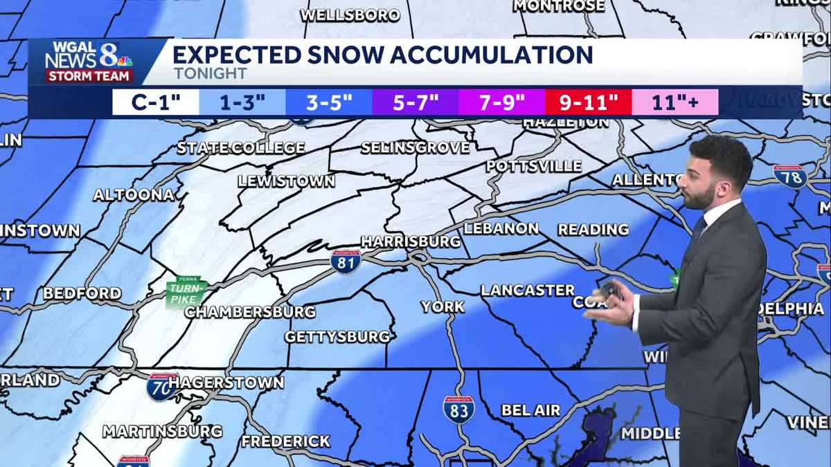
SNOWFALL TOTALS
North & West of I-81: Coating – 1″ is expected.
South & East of I-81: 1 – 3″ is expected.
However, southeastern communities in York & Lancaster counties may see 3 – 5″ of snow. Here’s how much snow to expect at your house:

Hearst OwnedWGAL
Snowfall map from the News 8 Storm Team for the night of December 13, 2025.

Hearst OwnedWGAL
Timeline of snowfall

Hearst OwnedWGAL
Expected snow impacts across the Susquehanna Valley. Travel may be slow at times with closings & delays remain possible
IMPACT SUNDAY
For Sunday, expect winds to be breezy, between 10-15 mph out of the west-northwest, and temperatures holding steady in the low to mid-20s for most of the day. Then, by the afternoon, winds will intensify to 15-25 mph with gusts to 35 mph. That will make it feel like the single digits all day Sunday! Due to these single digit wind chills, we have made Sunday an Impact Day.
The forecast looks dry and cold Monday and Tuesday, as high pressure moves overhead. Highs won’t get out of the 20s on Monday, but Tuesday’s highs will be near freezing.
Temperatures will warm to the low-to-mid 40s on Wednesday and the upper 40s on Thursday. Rain is back in the forecast on Thursday as a cold front passes.
Temperatures cool to near 40 degrees at the end of the week, which is seasonable for this time of the year.
Another chance of rain showers is in the forecast for Saturday, followed by a dry and milder Sunday.
Have a great weekend!
~ Ryan