
IMPACT: Widespread snow overnight, then bitter cold sets up Sunday across south-central Pennsylvania
A quick-moving system will bring light snow across the Susquehanna Valley this evening and exit by sunrise Sunday. Strong winds and cold temperatures will lead to single-digit wind chills all day on Sunday.
TONIGHT. COMING UP RIGHT AFTER NEWS EIGHT AT 11. TAKING A LIVE LOOK OVER CARLISLE, EPHRATA, GETTYSBURG, HERSHEY, SEEING THE SNOW FALL, SEEING SOME WET LENSES RIGHT NOW, SOME WET ROADS RIGHT NOW TO A LITTLE BIT OF A LIGHT BREEZE, I WOULD SAY. BUT YOU CAN START TO SEE THERE’S REALLY SOME SNOW FALLING. CHECK OUT CARLISLE HERE. YOU CAN REALLY SEE THE SNOWFLAKES BEING YOU CAN REALLY SEE THEM BEING AMPLIFIED IN THE THE STREET LAMP THERE. BUT YOU CAN SEE ACROSS THE SUSQUEHANNA VALLEY SEEING SOME LIGHT TO MODERATE SNOW FALLING ACROSS THE AREA. WE’RE GOING TO CONTINUE TO TRACK THAT AS WE GET INTO THE OVERNIGHT PERIOD. YOU CAN SEE ON STORM TEAM LIVE RADAR NETWORK. YOU SEE SOME OF THE LIGHTER WHITES HERE AND THE THICKER BANDS OF SOME WHITE. YOU CAN SEE SOME HEAVIER SNOWFALL RATES RIGHT NOW OVER FRANKLIN COUNTY TOWARDS CUMBERLAND COUNTY, ALSO TOWARDS PORTIONS OF ADAMS COUNTY. YOU CAN SEE SOME HEAVIER SNOWFALL ALSO TOWARDS HARRISBURG, SEEING A STRIPE OF SOME SOME HEAVIER SNOW STARTING TO MOVE FROM NORTHWEST DOWN TOWARDS THE SOUTHEAST. BUT WE’RE GOING TO START TO SEE MORE OF THESE HEAVIER SNOWFALL RATES. LOOK AT THIS. LOOK WHAT’S COMING FOR FOR SOUTHEASTERN COMMUNITIES. THIS IS STARTING TO MOVE TOWARDS MORE TOWARDS THE NORTHEAST, EVENTUALLY TO LANCASTER AND YORK COUNTIES. WE’RE GOING TO START TO SEE MORE OF THAT SNOW AS WE GET INTO THE OVERNIGHT PERIOD. COULD BE SEEING SOME SOME DECENT SNOWFALL AMOUNTS AS WE GET FOR OUR SOUTHEASTERN COMMUNITIES. NOW, WHAT ELSE ARE WE TRACKING OUTSIDE OF TONIGHT, OUTSIDE OF THE WIDESPREAD SNOW OVERNIGHT TONIGHT WE’LL SEE. VERY COLD AND BLUSTERY CONDITIONS AS WE GET INTO THE OVERNIGHT PERIOD WITH SINGLE DIGIT WIND CHILLS ON TAP FOR US FOR SUNDAY AFTERNOON AND A COLD START TO NEXT WEEK, THEN MILDER FOR NEXT WEEK. I’LL SHOW YOU THAT IN THE TEN DAY FORECAST WE COULD SEE UPPER 40S AS WE GET INTO AS WE GET INTO THE WORKWEEK. SO OVERNIGHT TONIGHT, WIDESPREAD SNOW, HEAVIEST OF THAT SNOW IS GOING TO BE SOUTHEAST AND ENDING BEFORE SUNRISE. TEMPERATURES GETTING DOWN INTO THE MID 20S. YOU SEE WINDS I WOULD SAY START TO PICK UP BETWEEN 5 AND 15MPH AS WE GET INTO THE OVERNIGHT PERIOD. THEN FOR TOMORROW MORNING, █SNOW BEGINS TO END EARLY, I WOULD SAY AROUND 4 OR 5:00 IN THE MORNING, REMAINING MOSTLY SUNNY. START TO SEE THOSE WINDS INCREASE OUT OF THE NORTHWEST. CHECK THIS OUT BETWEEN 10 AND 20MPH AS WE GET INTO THE MORNING TEMPERATURES. GETTING INTO THE LOW 20S. SO WHAT DOES THAT MEAN? THE WIND CHILLS ARE GOING TO BE LOW AS WE GET INTO TOMORROW. THAT’S WHY WE’VE MADE THE ENTIRE DAY TOMORROW AN IMPACT DAY. WE’LL SEE SOME INCREASING CLOUDS FOR THOSE SINGLE DIGIT WIND CHILLS. I’LL SHOW YOU THAT IN A BAR GRAPH COMING UP HERE SOON. COULD SEE SOME FLURRIES IN OUR NORTHWESTERNMOST COMMUNITIES LATE IN THE DAY, IN THE AFTERNOON AND THE EVENING. AND YOU CAN SEE GUSTS THOUGH, GETTING UP TO 35MPH FOR THE AFTERNOON. SO LET’S CHAT ABOUT TONIGHT. EVERYBODY’S BEEN ASKING ABOUT TONIGHT. THE SNOW, THE WIDESPREAD SNOW HAS BEEN DEVELOPING SINCE EARLIER THIS EVENING ENDING BEFORE SUNRISE FOR YOUR SUNDAY. BUT IT’S GOING TO BE THE LIGHT AND FLUFFIER TYPE OF SNOW IN TERMS OF TOTALS. NORTH AND WEST OF I-81, A COATING TO ONE INCH IS WHAT WE’RE EXPECTING. OTHERWISE, EXPECT ABOUT 1 TO 3IN, ALTHOUGH WITH THE EXCEPTION OF SOUTHEASTERN COMMUNITIES IN YORK AND LANCASTER COUNTIES, 3 TO 5IN ARE ON TAP FOR SOME OF THE AREAS. SO, FOR EXAMPLE, DELTA FAWN GROVE STRASBURG EVEN DOWN TOWARDS QUARRYVILLE TOWARDS THE SOUTHERN END OF LANCASTER, GETTING CLOSER TOWARDS LITTLE BRITAIN. THE FURTHER SOUTHEAST YOU GO IN THE SUSQUEHANNA VALLEY, THE MORE YOU’RE GOING TO BE SEEING MORE OF THAT SNOW. SO THAT’S WHY THAT’S OUR TOTALS AS WE GET INTO TONIGHT, COULD SEE 1 TO 2 INCH PER HOUR SNOWFALL RATES FOR SOUTHEASTERN AREAS, BUT THAT’S GOING TO BE CREATING POOR ROAD CONDITIONS. SO IF YOU’RE TRAVELING TONIGHT, YOU’RE GOING TO MAKE SURE YOU’RE TAKING IT EASY ON THE ROADS TODAY OR FOR TONIGHT. HERE’S THE EXPECTED SNOWFALL ACCUMULATION ACROSS THE AREA. SEE OUR SNOWFALL MAP FOR OUR SOUTHEASTERN MOST COMMUNITIES LOOKING LIKE LOOK AT THIS. 3 TO 5IN, THEN 1 TO 3IN FOR THIS LIGHTER BLUE SHADE. AND THEN ABOUT A COATING TO ONE INCH OF SNOW FOR AREAS NORTH AND WEST OF I-81. NOW, IN TERMS OF THE PRECIPITATION TIMELINE, EXPECT TO SEE START TO SEE THAT SNOW BECOME A LITTLE BIT MORE WIDESPREAD THAN ENDING BY SUNRISE SUNDAY. THEN WE’LL START TO DRY OUT AS WE GET INTO THE REST OF THE DAY. SUNDAY. IN TERMS OF TRAVEL CONDITIONS THAT WILL BE SLOW AT TIMES FROM TONIGHT INTO EARLY SUNDAY MORNING. SO IF YOU HAVE SUNDAY SERVICES THAT YOU’RE TRYING TO GO TO, MAKE SURE YOU TAKE IT EASY ON THE ROADS COULD BE SOME POSSIBLE CLOSINGS AND DELAYS. POWER OUTAGES REMAIN LOW, VISIBILITY WILL BE REMAINING FAIR. BUT HERE’S WHAT THE OTHER STORY IS. TOMORROW IS IMPACT DAY. LOOK AT THE WIND GUSTS FOR TOMORROW. GETTING INTO THE 30S 30 TO 35MPH COULD BE GUSTING FOR THE AFTERNOON. AND THEN CHECK OUT THE AIR TEMPERATURES GETTING DOWN TO THE 20S. PAIR THAT WITH GUSTING AT 35MPH. YOU’RE GOING TO GET THAT INTO THE SINGLE DIGITS. THE WIND CHILLS THE FEELS LIKE TEMPERATURES AS WE GET INTO THE AS WE GET INTO SUNDAY. NOW THAT’S WHAT WE’RE EXPECTING FOR IMPACT DAY ON SUNDAY FOR POSSIBLE WIND CHILLS NEAR ZERO DEGREES AS WE GET TO SUNDAY NIGHT. NOW TEMPERATURES ACROSS THE AREA INTO THE 30S AS WE SPEAK. ONE LAST LOOK AT STORM TEAM LIVE RADAR NETWORK. STILL GOING TO BE TRACKING THIS SNOW AS WE GET INTO THE OVERNIGHT PERIOD. AND ALSO TO VERY EARLY SUNDAY MORNING. SO IMPACT DAY SUNDAY FOR WIND CHILLS INTO THE SINGLE DIGITS. BLUSTERY AND COLD FOR YOUR MONDAY. STILL COLD FOR TUESDAY. BUT LOOK AT THIS WARM UP INTO WEDNESDAY, THURSDAY AND FRIDAY. WE ALSO HAVE ANOTHER CHAN
IMPACT: Widespread snow overnight, then bitter cold sets up Sunday across south-central Pennsylvania
A quick-moving system will bring light snow across the Susquehanna Valley this evening and exit by sunrise Sunday. Strong winds and cold temperatures will lead to single-digit wind chills all day on Sunday.

Updated: 12:11 AM EST Dec 14, 2025
A Winter Weather Advisory has been issued for Lancaster, York, Adams, and Lebanon counties from NOW through 8 AM Sunday.IMPACT TONIGHTWe’re watching a quick-moving system that will bring snow showers from overnight tonight and taper before sunrise Sunday. Temperatures will drop through the low 30s through the evening, then bottom out in the mid 20s overnight. Winds will remain light at about 5-10 mph breeze out of the northwest, then it will become breezy heading into Sunday.SNOWFALL TOTALSNorth & West of I-81: Coating – 1″ is expected.South & East of I-81: 1 – 3″ is expected.However, southeastern communities in York & Lancaster counties may see 3 – 5″ of snow. Here’s how much snow to expect at your house:IMPACT SUNDAYFor Sunday, expect winds to be breezy, between 10-15 mph out of the west-northwest, and temperatures holding steady in the low to mid-20s for most of the day. Then, by the afternoon, winds will intensify to 15-25 mph with gusts to 35 mph. That will make it feel like the single digits all day Sunday! Due to these single digit wind chills, we have made Sunday an Impact Day.The forecast looks dry and cold Monday and Tuesday, as high pressure moves overhead. Highs won’t get out of the 20s on Monday, but Tuesday’s highs will be near freezing.Temperatures will warm to the low-to-mid 40s on Wednesday and the upper 40s on Thursday. Rain is back in the forecast on Thursday as a cold front passes.Temperatures cool to near 40 degrees at the end of the week, which is seasonable for this time of the year.Another chance of rain showers is in the forecast for Saturday, followed by a dry and milder Sunday.Have a great rest of your night!~ Ryan
A Winter Weather Advisory has been issued for Lancaster, York, Adams, and Lebanon counties from NOW through 8 AM Sunday.
IMPACT TONIGHT
We’re watching a quick-moving system that will bring snow showers from overnight tonight and taper before sunrise Sunday. Temperatures will drop through the low 30s through the evening, then bottom out in the mid 20s overnight. Winds will remain light at about 5-10 mph breeze out of the northwest, then it will become breezy heading into Sunday.
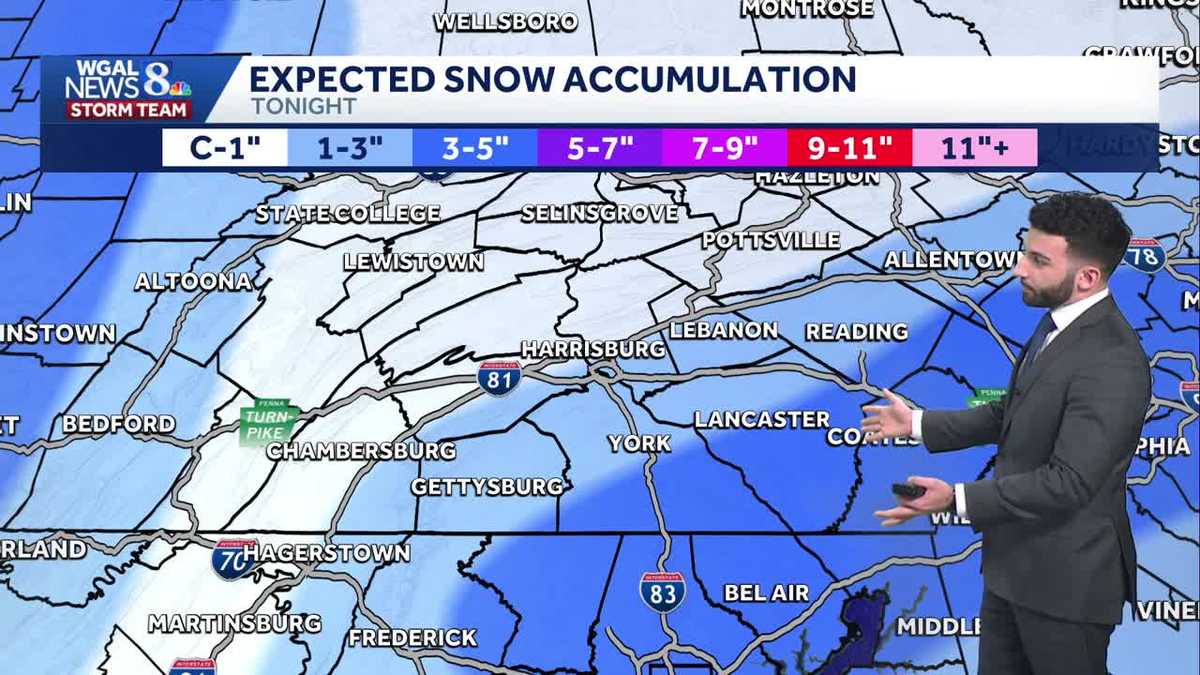
SNOWFALL TOTALS
North & West of I-81: Coating – 1″ is expected.
South & East of I-81: 1 – 3″ is expected.
However, southeastern communities in York & Lancaster counties may see 3 – 5″ of snow. Here’s how much snow to expect at your house:
IMPACT SUNDAY
For Sunday, expect winds to be breezy, between 10-15 mph out of the west-northwest, and temperatures holding steady in the low to mid-20s for most of the day. Then, by the afternoon, winds will intensify to 15-25 mph with gusts to 35 mph. That will make it feel like the single digits all day Sunday! Due to these single digit wind chills, we have made Sunday an Impact Day.
The forecast looks dry and cold Monday and Tuesday, as high pressure moves overhead. Highs won’t get out of the 20s on Monday, but Tuesday’s highs will be near freezing.
Temperatures will warm to the low-to-mid 40s on Wednesday and the upper 40s on Thursday. Rain is back in the forecast on Thursday as a cold front passes.
Temperatures cool to near 40 degrees at the end of the week, which is seasonable for this time of the year.
Another chance of rain showers is in the forecast for Saturday, followed by a dry and milder Sunday.
Have a great rest of your night!
~ Ryan