
Western Pennsylvania begins the climb out of the deep freeze today! High temperatures will reach the freezing mark, or slightly above. The “warming” trend continues through Thursday. We have shuffled the inbound Impact Day. Rain looks to arrive later on Thursday. Greater travel impacts will be felt Friday morning, which is now our Impact Day.Thawing outHigh temperatures will reach freezing Tuesday. The thaw will push readings into the 40s on Wednesday and near 50° on Thursday. We can expect some rays of sunshine today and tomorrow too.Rain late Thursday, Impact Day Friday morningThe timing of our next precipitation chance has been pushed back. Rain will hold off until late Thursday evening. Your drive home from work will remain dry. The later onset means a later exit Friday morning. Chilly air will be working in too. On the tail end, rain will be changing to light snow showers. A brief period of icing can’t be ruled out. Roads can quickly turn slick and icy. Milder trend starts this weekendFriday will feature a brief cold shot with highs in the lower 30s. Temperatures will trend more seasonal for the weekend with highs in the 40s. This is the beginning of a pattern change. It looks like it won’t be a white Christmas for western Pennsylvania this year.TODAY: Still cold with sun and clouds. High: 34°.TONIGHT: Partly cloudy and not quite as cold. Low: 30°.WEDNESDAY: Milder with increasing clouds. High: 40°, low: 28°.THURSDAY: Windy and warmer with cloudy skies. Rain arrives late. High: 50°, low: 28°.FRIDAY – Impact Day: Windy with morning rain changing to a few flakes. Temperatures drop throughout the day. High: 45°, low: 20°.
PITTSBURGH —
Western Pennsylvania begins the climb out of the deep freeze today! High temperatures will reach the freezing mark, or slightly above. The “warming” trend continues through Thursday. We have shuffled the inbound Impact Day. Rain looks to arrive later on Thursday. Greater travel impacts will be felt Friday morning, which is now our Impact Day.
Thawing out
High temperatures will reach freezing Tuesday. The thaw will push readings into the 40s on Wednesday and near 50° on Thursday. We can expect some rays of sunshine today and tomorrow too.

Hearst OwnedHearst
High temperatures will reach freezing, or even a few degrees better, this afternoon.
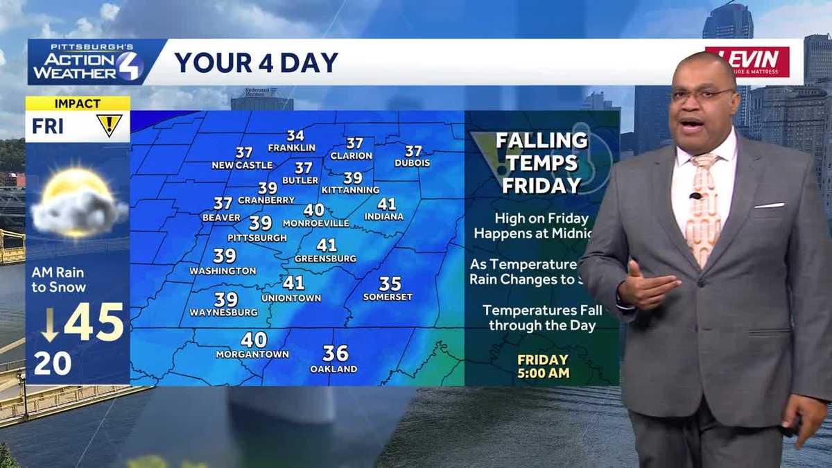
Rain late Thursday, Impact Day Friday morning
The timing of our next precipitation chance has been pushed back. Rain will hold off until late Thursday evening. Your drive home from work will remain dry. The later onset means a later exit Friday morning. Chilly air will be working in too. On the tail end, rain will be changing to light snow showers. A brief period of icing can’t be ruled out. Roads can quickly turn slick and icy.

Hearst OwnedHearst
Rain holds off until closer to midnight Friday. Dropping temperatures will lead to a trickier Friday morning commute with rain changing to a few flakes.
Milder trend starts this weekend
Friday will feature a brief cold shot with highs in the lower 30s. Temperatures will trend more seasonal for the weekend with highs in the 40s. This is the beginning of a pattern change. It looks like it won’t be a white Christmas for western Pennsylvania this year.

Hearst Owned
The thaw lasts through Thursday with rain accelerating our thaw Thursday night. More seasonal heading towards Christmas.
TODAY: Still cold with sun and clouds. High: 34°.
TONIGHT: Partly cloudy and not quite as cold. Low: 30°.
WEDNESDAY: Milder with increasing clouds. High: 40°, low: 28°.
THURSDAY: Windy and warmer with cloudy skies. Rain arrives late. High: 50°, low: 28°.
FRIDAY – Impact Day: Windy with morning rain changing to a few flakes. Temperatures drop throughout the day. High: 45°, low: 20°.