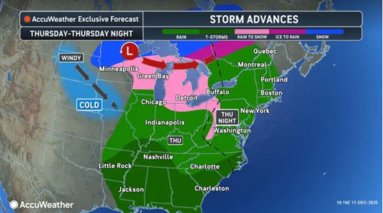
A strong cold front will bring moderate to heavy rainfall and potentially strong winds to the Lehigh Valley Thursday night through Friday morning, likely impacting the morning commute.
Temperatures on Wednesday are forecast to rise above freezing for the first time since the weekend snowstorm, as remnants of ice and gray slush linger on sidewalks and roads around the region.
Partly sunny to partly cloudy conditions are forecast Wednesday and overnight into Thursday as temperatures dip from daytime highs in the low to mid-40s to around 20 early Thursday, according to the National Weather Service forecast.
Highs in the mid- to upper 40s are forecast Thursday before the rain arrives at night. Temperatures will remain mild in the low 40s overnight into Friday. Winds are forecast to increase from 5 to 15 mph out of the southwest on Wednesday, with gusts as high as 25 mph Thursday night.
Temperatures early Friday will start in the 50s and drop throughout the day, with wind gusts potentially reaching 30-40 mph.
The National Weather Service forecasts rainfall amounts of 1 to 1.5 inches for the Lehigh Valley south to the Philadelphia area. Rain is expected to begin Thursday night and continue through midday Friday, according to the weather service.
While severe weather is not anticipated, urban and poor drainage areas may experience localized flooding.
AccuWeather warns the storm could create messy travel conditions.
Wind will be a significant factor as a strong cold front approaches late Thursday night and moves across the region on Friday. Gusts could potentially reach 40 mph in higher elevations like the Poconos. Residents should secure loose outdoor items and be prepared for potential power interruptions. The Friday morning commute could be challenging due to heavy rain and gusty conditions.
Saturday will bring more stable weather with high pressure moving in and temperatures returning to near-normal December levels in the upper 30s and low to mid-40s.
The extended forecast shows another cold front passing through Sunday, which is expected to be moisture-starved with minimal precipitation and breezy conditions. Temperatures will remain in the mid to upper 40s and low 50s.
Current weather radar