
Our next system is on approach & clouds are beginning to gradually increase this evening. Temperatures will hover in the mid 40s this evening, then steadily rise through late this evening into Friday morning. IMPACT TONIGHT:Rain will be moderate to heavy at times overnight. 0.50″ to 1″ of rain is expected through 9 a.m. Friday. In addition, strong wind gusts are likely. Expect sustained southerly winds 15-25 mph, with gusts to 50 mph. Make sure Christmas decorations are secure, and watch for ponding water on the roads, some flooding in low-lying areas, and downed tree limbs. Isolated power outages are also possible.Temperatures may spike to the 50s overnight, especially in southern counties. After a cold front passes around sunrise Friday, temperatures will fall from the mid-40s to the upper 30s by afternoon. Passing rain/snow showers are possible behind the front with little to no accumulation. Winds will still be strong, gusting to 45 mph from the west-northwest. The sky will clear late.IMPACT FRIDAYIn the wake of the passing cold front, winds will remain elevated and be gusty throughout the day Friday. A Wind Advisory will go in effect from 1 AM Friday until 1 AM Saturday for the entire Susquehanna Valley. Sustained winds will be between 15-25 MPH, with gusts between 40-45 MPH. Be on the lookout for downed branches, isolated power outages, & secure your Christmas decorations this evening through Friday!Saturday will be brisk to start, then building high pressure will ease the wind by afternoon. Highs will be seasonable near 40 degrees.Milder highs in the mid-40s return Sunday and winds increase late, as a dry cold front passes.Monday will feature cooler highs in the mid-30s, then scattered rain showers are in store Tuesday, with temperatures close to 40 degrees. Christmas Eve looks dry and quiet.Another system will bring showers on Christmas Day into Friday. Precipitation should mainly fall as rain, as temperatures hover in the low 40s. We’ll keep you posted on any changes!Have a great Thursday!~ Ryan
Our next system is on approach & clouds are beginning to gradually increase this evening. Temperatures will hover in the mid 40s this evening, then steadily rise through late this evening into Friday morning.
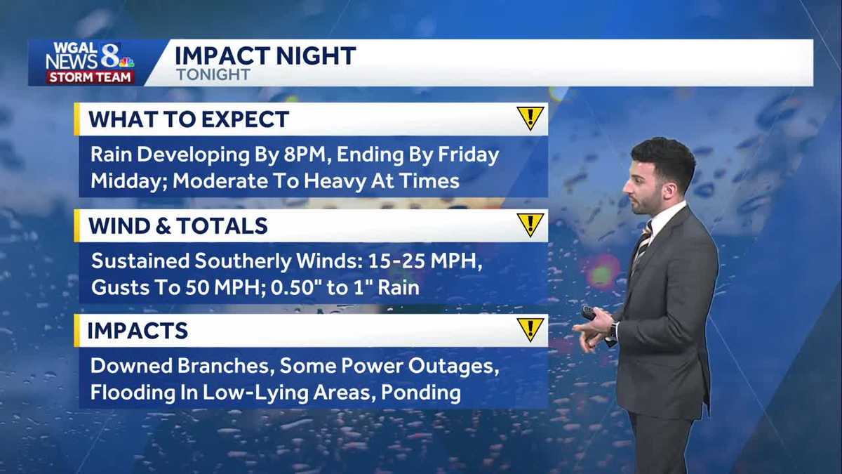
IMPACT TONIGHT:
Rain will be moderate to heavy at times overnight. 0.50″ to 1″ of rain is expected through 9 a.m. Friday. In addition, strong wind gusts are likely. Expect sustained southerly winds 15-25 mph, with gusts to 50 mph. Make sure Christmas decorations are secure, and watch for ponding water on the roads, some flooding in low-lying areas, and downed tree limbs. Isolated power outages are also possible.
Temperatures may spike to the 50s overnight, especially in southern counties. After a cold front passes around sunrise Friday, temperatures will fall from the mid-40s to the upper 30s by afternoon. Passing rain/snow showers are possible behind the front with little to no accumulation. Winds will still be strong, gusting to 45 mph from the west-northwest. The sky will clear late.
IMPACT FRIDAY
In the wake of the passing cold front, winds will remain elevated and be gusty throughout the day Friday. A Wind Advisory will go in effect from 1 AM Friday until 1 AM Saturday for the entire Susquehanna Valley. Sustained winds will be between 15-25 MPH, with gusts between 40-45 MPH. Be on the lookout for downed branches, isolated power outages, & secure your Christmas decorations this evening through Friday!
Saturday will be brisk to start, then building high pressure will ease the wind by afternoon. Highs will be seasonable near 40 degrees.
Milder highs in the mid-40s return Sunday and winds increase late, as a dry cold front passes.
Monday will feature cooler highs in the mid-30s, then scattered rain showers are in store Tuesday, with temperatures close to 40 degrees. Christmas Eve looks dry and quiet.
Another system will bring showers on Christmas Day into Friday. Precipitation should mainly fall as rain, as temperatures hover in the low 40s. We’ll keep you posted on any changes!
Have a great Thursday!
~ Ryan